Monagas
Monagas | |
|---|---|
 | |
 Flag | |
| Motto(s): Resistió con valor (English: It resisted with courage) | |
| Anthem: Himno del Estado Monagas | |
 Location within Venezuela | |
| Coordinates: 9°26′N 63°05′W / 9.43°N 63.08°WCoordinates: 9°26′N 63°05′W / 9.43°N 63.08°W | |
| Country | Venezuela |
| Created | 1909 |
| Capital | Maturín |
| Government | |
| • Body | Legislative Council |
| • Governor | Cosme Arzolay(2021–present) |
| • Assembly delegation | 6 |
| Area | |
| • Total | 28,900 km2 (11,200 sq mi) |
| Area rank | 9th |
| 3.15% of Venezuela | |
| Population (2011 census) | |
| • Total | 905,443 |
| • Rank | 13th |
| 3.15% of Venezuela | |
| Time zone | UTC−4 (VET) |
| ISO 3166 code | VE-N |
| Emblematic tree | Palma de Moriche (Mauritia flexuosa) |
| Website | www |


Monagas State (Spanish: Estado Monagas, IPA: [esˈtaðo moˈnaɣas]) is one of the 23 states of Venezuela.

Monagas State covers a total surface area of 28,900 km2 (11,200 sq mi) and, as of the 2011 census, had a population of 905,443.
Monagas State is surrounded by Sucre State in the north, Anzoátegui State in the west and south, Bolívar State in the south, Delta Amacuro State in the south and east and the Paria Gulf in the northeast.
The state is named after the general and president of Venezuela José Tadeo Monagas, native from this state, and his brother and fellow president José Gregorio Monagas, native from the neighbor Anzoátegui State.
The capital of the state is Maturín.
History[]
Pre-colonial stage[]
It dates back to the settlement of the territory by aborigines of different ethnicities hundreds of years ago, among which we can mention the Waraos and Kariña ethnicities, where they were accentuated mainly in the Orinoco Delta and the Chaima Indians in the north of the State. The first aborigines to make a presence in the northern part of the region were the Chaima Indians, belonging to the Capaya tribe. The Capuchin missionary Fray Gerónimo de Muro, with the help of the Carib, Cuaca and Chaima Indians, founded the town of San Antonio de Maturín, which is now San Antonio de Capayacuar, on August 7, 1713.
Although the settlement of the territory was slow, archaeological excavations and commentaries by the chroniclers of the Indies point to the existence of a well-developed village in Barrancas in the year 1530, when the Conqueror Diego de Ordás passed through the area in search of El Dorado. Also in the 16th century missionaries arrived in the highlands and slowly the Christianisation and re-education of the Indians spread to the south; they thus adapted to a more sedentary life.
In the site where Barrancas is located today, archaeological objects and utensils have been found that belonged to the so-called Barrancoid and Saladoid cultures, the oldest of which have been dated 1000 years before the Christian era. The archaeological evidence that has been found (and that is still being found) has allowed to establish that Barrancas has been uninterruptedly inhabited at least since the 11th century of our era, which makes it the oldest town in Venezuela and one of the oldest in the American continent.
Spanish Colonization[]

Diego de Ordaz, a Spanish explorer obsessed with finding the legendary site of El Dorado, arrived in the village in August 1531 after traveling up the Orinoco River via the Caño Manamo. Impressed by its number of inhabitants - which he estimated at "more than 400 bohíos" - he decided to go down and meet personally with the cacique "Naricagua", lord of his territories, whose name of the river "Uyapari" was associated with the village. The chronicler Juan de Castellanos, in his Elegies of Illustrious Men of the Indies, describes it as "a powerful town of great people that on the ravines was placed the Cacique of Uyapari lordship".[citation needed]
San Antonio de Capayacuar was founded on August 7, 1713 by the Capuchin missionary Fray Gerónimo de Muro with the help of Carib Indians, cuacas and chaimas.
On April 20, 1731, the Aragonese Fray Antonio de Blesa founded Santo Domingo de Guzmán de Caycuar, the area was inhabited by chaimas and outcasts when the Capuchin missionaries arrived, this settlement would later be called Caicara de Maturín.
A Catholic mission of Chaima Indians with the Capuchin missionary Pedro de Gelsa, founded the San Miguel Arcangel de Caripe settlement on October 12, 1734, which would later become Caripe.
Maturín was founded on December 7, 1760 by the Capuchin friar Lucas de Zaragoza.
The territory where Aguasay is now located was founded in 1769 by Friar Manuel de La Mata.
Uracoa was founded in 1784 by Friar José de Manzanera. In 1799 the German geographer Alejandro de Humboldt and the Frenchman Aimeé Bonpland visited Caripe as part of their trip through Venezuela. Other explorers who toured the area were the Italian Agustín Codazzi (1835) and the German Ferdinand Bellermann (1843).

19th and 20th Centuries[]
In 1856, the Province of Maturín was created, separated from that of Cumaná. By 1864 the Maturín State was ratified. But in 1879, Monagas was annexed to the State of Oriente and, from 1891 to 1898, it belonged to the State of Bermúdez.
In 1904, Maturín became the capital of the Monagas district of Bermúdez State, whose capital was Cumaná. For a long time, Monagas was an extremely poor state. During the 16th and 17th centuries, the plains and swamps north of the Orinoco, under the rule of the Caribs, made alliances with the French and Dutch as a policy of tenacious resistance against Spanish domination. On ancient maps these lands are called Caribana, kingdom of the Caribs.
Although the settlement of the territory was slow, archaeological excavations and commentaries by Indian chroniclers point to the existence of a well-developed village in Barrancas in the year 1530, when Conqueror Diego de Ordás passed through the area in search of El Dorado. In the 16th century, missionaries arrived in the highlands and slowly the Christianisation and re-education of the Indians spread to the south; they thus adapted to a more sedentary life.
In 1909 the State of Monagas was created with its current boundaries. In honor of General José Tadeo Monagas. In 1924 the Standard Oil Company starts the oil exploration activities in the area of Caripito that experiences a slight repopulation. With the bursting of the Moneb No. 1 well, in the Quiriquire field in 1928, oil exploitation begins and the area reaches an important impulse[tone] in its urban development due to the arrival of migrant labor, particularly from the Caribbean islands.[citation needed]
In 1929 the Standard Oil Company begins to build the storage yard and the deep water dock on the San Juan River and on October 15, 1930 the Creole Bueno tanker leaves the port of Caripito with 20 thousand barrels of oil bound for Trinidad.
In 1935, the aquatic terminal of Caripito was inaugurated, located on the San Juan River, where S-42 seaplanes of the Pan American Airways company arrived and included it in the Central American and Caribbean route.
In 1936 the Caripito International Airport is selected by the aviator Amelia Earhart and her navigator Fred Noonan as the second stopover of their trip around the world staying at the Standard Oil Company facilities. The event was widely publicized in the world press and the company gave them the logistical support to continue the flight through South America.
On November 15, 1940 the city of Punta de Mata was founded. On December 28 of that same year the first oil well was drilled in that area, in addition the Legislative Assembly of Monagas considered the convenience of creating the Bolivar District and integrated to its territory the municipalities of Punceres and Colon, designating Caripito as the capital, according to the decree of January 19, 1940, signed by Governor Jose Maria Isava on January 30 of the same year.
Under the direction of the Corporación Venezolana de Guayana, several hectares of Caribbean pine were planted between Barrancas and the nearby town of Uverito, an activity that significantly boosted the development of the area. By the 1970s, it was the most important population[citation needed] and port in the state of Monagas, mainly due to the lack of land road connections to the main nearby cities, such as Tucupita (Delta Amacuro) and Puerto Ordaz (State of Bolivar), although today it continues to be an important center for the collection of goods and passengers to these cities.[citation needed]
In 1976, the assets of Creole were nationalized and were managed by Lagoven, later by Corpoven and now by PDVSA in association with Repsol. By closing the refinery in 1976 and the oil terminal in 2002, an attempt was made to boost agricultural activity to take advantage of fertile areas by growing cocoa, pepper, Chinese ocumo, white ocumo and yucca.
The newspaper El Oriental was founded in 1982 in the city of Maturín. On August 20, 1983, the State Legislative Assembly declared the creation of the Municipal Council of the Libertador Municipality, in accordance with the provisions of the law of Political Territorial Division of the State of Monagas, allowing the creation of the Libertador Municipality. Since 1989, with the administrative reforms that were approved for the whole country, the state of Monagas elected for the first time in a direct and secret way its own governor and Legislative Assembly (called since 2000 Legislative Council).
In 2021 was asigned Cosme Arzolay how Governor temporaly.[1]
Geography[]

Relief[]
The state has many plateaus and savannas located in the southwest. In the northeast and the southeast there are deltaic savannas in which rivers such as San Juan, Guanipa, Caño Mánamo, Río Tigre flow into. In the northwest there is a group of mountains belonged to the eastern mountain range. This mountain range is divided in two massifs: the massif of el Turimiquire (in which the town of San Antonio is located) and the massif of Caripe (in which the town of Caripe is located). Cerro Negro (2000 m.) is the highest mountain of Monagas State. The mountain landscape presents a geological material of Cretaceous age, constituted exclusively by sedimentary rocks, predominantly sandstones, shales and limestones, being the main geological formations: El Cantil, Barranquín, Guayuta and Querecual; it has elevations between 400 and 2 300 m.a.s.l., with valleys and depressions.
Climate[]
The weather is hot in the area of the Llanos, while it is cold in the mountains located in the north of the state. The average temperature in the low areas is between 25 and 28 °C. In the area of the town of Caripe the cold temperature permits the cultivation of certain kind of typical plants from cold weathers as roses and strawberries. The level of rainfalls in the state is between 530 and 1400 mm during the year.
Dominated by a rainy tropical climate with some local variations that respond to various factors such as altitude, wind and proximity to the sea. Most of the state, in the southern strip, has a climate typical of savannahs with dry seasons that can last up to six months, which produces a severe water shortage. The average annual temperature of Monagas is approximately 27 °C. In Maturín, Temblador and Uverito, average temperatures are between 26° and 27 °C.
Hydrology[]

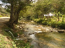
The rivers of the state belong to one of the two basins that are located in the state. The basins are the basin of Atlantic Ocean and the basin of the Orinoco River. Rivers such as Guanipa, Río Tigre, Morichal Largo, Caño Mánamo, Amana, Tonoro, Tabasca, Uracoa flow into the Orinoco River. On the other hand, the rivers Guarapiche, San Juan, Río de Oro, Caripe flow into the Atlantic Ocean. The rivers of the Atlantic Ocean basin come from the mountains located in the northwest of the state and the rivers of the Orinoco river basin come from the many plateaus located in the southwest of Monagas State and from Anzoategui State.
It has an extensive hydrographic network with a fairly uniform geographical distribution, with the Guarapiche River standing out in the area of the tables. The rivers are numerous and of little depth, marking the end of the piedmont in which three river basins are located with course north-south that are: that of the rivers Amana-Areo, Guarapiche, Púnceres-Aragua. From west to east the rivers Tácata, Tonoro, Caris, Guanipa and El Tigre cross the state. Monagas State has a great number of moderate rivers and streams, among the main ones;
- Guarapiche River
- Mapirito River
- Tigre River.
- Morichal Largo River
- San Juan River

Vegetation[]
The vegetation is the intertropical one. This vegetation is adapted to the different altitudes, weathers and kinds of soil of the state. Typical trees are el araguaney, la ceiba, el jobo, el aceituno, la vera, la palma de moriche and el mangle. The State of Monagas has a very wide biodiversity like other states in Venezuela. More than 2000 species of vascular flora have been catalogued within the Monagas territory [citation required] The most symbolic tree of the Moriche along the Morichal Largo River. The dominant vegetation in the north of Monagas State is the rain forest, like the one found in the mountainous area of the San Juan River valley and the Acosta and Caripe municipalities. In these cold areas, it is possible to grow temperate plants such as strawberries and roses. However, in the flat regions, towards the south-east of the state, intertropical savannah vegetation dominates, such as thorn bushes, grasses, cujíes and other varieties that have adapted to the conditions of the state such as Ceiba, jobo, Caribbean pine, jabillo and carob tree. Another variation of the vegetation present in Monagas State, can be found along the banks of the main rivers, where extensive forests of mangroves, palms and morichals have been formed.
Protected areas[]

Cueva del Guácharo National Park, was created in May 1975 by the Venezuelan government to protect the ecosystem surrounding the Guacharo's Cave. The park has a surface area of 155 km2 (60 sq mi) and covers the mountainous areas of Acosta and Caripe municipalities in Monagas state and Ribero municipality in Sucre state.
Alejandro de Humboldt National Monument can be located inside the park El Guácharo. This national monument was created in 1949 to protect the Guacharo's Cave. This national monument is named after the German explorer Alexander von Humboldt, who visited the Guacharo's cave in 1799.
Another protected area is Guarapiche Forestal Reserve, which protects the forests located at the bank of Guarapiche and San Juan Rivers.
Municipalities and municipal seats[]

- Acosta ()
- Aguasay ()
- Bolívar (Caripito)
- Caripe (Caripe)
- Cedeño ()
- Ezequiel Zamora (Punta de Mata)
- Libertador ()
- Maturín (Maturín)
- Piar (Aragua de Maturín)
- Punceres ()
- Santa Bárbara ()
- Sotillo ()
- Uracoa ()
Demography[]
The population of Monagas State has increased since the 1920s due to the opening of its oil fields. The majority of its inhabitants are Mestizo|mestizos; that is, they result from the progeny of native Indians, Black Africans and White Europeans. Many people from neighbouring states as Sucre and Nueva Esparta, as well as persons from other countries as Spaniards, Italians, Portuguese, Syrian, Lebanese and Chinese have immigrated to the state because of the petroleum industry and business opportunities. The majority of the population is concentrated in the northern area of Monagas state. At least fifty percent of inhabitants live in the capital state Maturín. The most populated cities are: Maturín (514 046 inhab.), Punta de Mata (69 000 inhab.), Caripe (37 350 inhab.), Caripito (52 000 inhab.) and Temblador (36 000 inhab.).
Monagas also has inhabitants of the Warao and Kariña ethnic groups.
Race and ethnicity[]
According to the 2011 Census, the racial composition of the population was:[2]
| Racial composition | Population | % |
|---|---|---|
| Mestizo | N/A | 54.8 |
| White | 359,473 | 38.8 |
| Black | 42,618 | 4.6 |
| Other race | N/A | 1.8 |
Economy[]

The main economical activity is the exploitation of oil. Many towns as Punta de Mata, El Tejero, Temblador depend on this activity.
Other towns as Caripe and San Antonio live off agriculture and livestock farming. Coffee is planted in the areas next to the towns of Caripe and San Antonio. Cocoa is being cultivated near Caripito. Maize, tomato, sugar-cane, tobacco, banana, rice, yucca and tropical fruits grow in other areas.
Cattle is concentrated in the southern and western parts of Monagas, where there are great extensions of savannas and plateaus.
The state has forests with its corresponding industry.
Because of the oil exploitation Maturín is a main commercial and banking centre in the east of Venezuela.
Tourism[]
Natural heritage[]
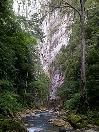
- Puertas de Miraflores: also called Puertas del Guarapiche, it's a gorge or canyon where the Guarapiche river is born. It is formed by two rocky walls 100 meters high.
- El Guamo Dam: contains the waters of the Guarapiche, Colorado, Cocollar and other rivers. It is built over the ruins of the towns of San Francisco, Cachimbo and Colorado. It has a park.

- Spa Miraflores: its waters come from the Guarapiche river and have temperatures that oscillate between 18 °C and 26 °C. It has a road that leads the traveler to the Gates of Miraflores.
- La Bomba de Caripito Spa in the La Tubería sector.
- Río Selva Spa, a spectacular natural space with crystalline waters provided by the waters of the Tabasca and Uracoa Rivers. Located in the town of Tabasca, has accommodation facilities, bathrooms, air conditioning, restaurant, swimming pool with natural water from morichales, kiosks with grills and dressing rooms.
- Poza de Azufre: Located in the Los Morros Sector. This busy space is suitable for health tourism because of the healing properties of the pool, formed by the outbreak of groundwater with a high content of copper and sulfur. It has a temperature of approximately 69 °C.
- Cascada el Nazareno: In the middle of a tropical forest, there is a waterfall of more than 50 meters high on an immense rock. It is also known as the poza el nazareno.[citation needed]
- Morichal Largo River, is formed by deltaic plains and forests of galleries that border its margins. The predominant plant species in this rainforest is the moriche tree, whose roots penetrate deep into the underground water reserves, giving rise to the springs that feed the flow of the rivers in the region.
- Yagrumito Volcano: is a mud volcano located 6 km southeast of the city of Maturin, is about 2 or 3 m in relative height and occupies about 2000 m² (including mud pools and mudflats without vegetation) although the cone alone should not exceed about 400 m². The crater opening is approximately 50 cm in diameter.
Built heritage[]

- Our Lady of Mount Carmel Cathedral: Romanesque style Catholic temple. It is located between Bolivar Avenue and Monagas Street. Inaugurated in 1981, the Nuestra Señora del Carmen Cathedral is considered[by whom?] one of the most modern cathedrals in Latin America. It has stained glass windows that adorn its interior.[citation needed]
- San Simón de Maturín Church: it is the oldest Catholic temple in Maturín. It was built between 1884 and 1887. It is of neo-Gothic style, with arches in the shape of a warhead. It has a central tower on the façade. It is located on Rojas Street, in front of Bolívar Square.
- Church of San Francisco de Guayareguar: is located near the El Guamo Dam.
- Williams H. Phelps Public Library: inaugurated on September 5, 1948. It was built and donated by William H. Phelps Sr.6
- Mural of the Foundation of San Antonio de Capayacuar: erected in 1987 It is located at the entrance of San Antonio.
- Church of San Antonio de Padua of San Antonio de Maturín.
- El Playon - Community "Culantrillar" Parish San Antonio (Acosta)
- Sagrado Corazón de Jesús Church, Caripito: it is the main catholic temple of the place was built in 1936.

- Casa de la Cultura Juvenal Ravelo de Caripito: It is a cultural house inaugurated in 1974. It has an auditorium, an exhibition hall, dressing rooms, a conference room, a library, multipurpose rooms and an internal recreational square. It is located in the El Bajo sector, Boyacá Avenue. It is named in honor of Juvenal Ravelo, a native artist from Caripito.
- Monument to the Nazarene: built in 2.05 with cement, rods, galvanized steel meshes, by sculptor Jesus David Martinez . It consists of an image of the Nazarene, 20 meters high, carrying his cross on a slope and dressed in a purple tunic with gold trimmings.
- Caripito's religious museum: it houses life-size images and other religious-type objects.
- Hacienda Sarrapial: typical house of the time of the agrarian Venezuela. It is the headquarters of the Monaguense Tourism Corporation. It is located on Alirio Ugarte Pelayo Avenue, on the Boquerón hill.
- Uyapari Museum: Anthropological museum founded in 1984, on the old seat of the National School Uriapara, in front of the Plaza Bolívar. It is the most important center for the diffusion of the Barrancoide culture,[citation needed] the oldest in Venezuela, highlighting the scientific work for the rescue of the archaeological heritage, such as the realization of workshops for the manufacture of replicas of original Barrancoide pieces.[citation needed]
- Church of San Rafael Arcángel de (Barrancas del Orinoco): Catholic temple originally built in Bahareque in 1790 by Fray Joaquín de Morata. It was rebuilt in 1931 with a cement structure and in 1984 it was the object of an expansion process that culminated in 1987. The original facade was kept, although it was reinforced to accommodate a capacity of 3,000 people.
Parks[]

- Andrés Eloy Blanco Park: located on the southern road.
- Parque del Este: located in La Floresta.
- La Guaricha Zoo: located on Raúl Leoni Avenue, near the old terminal of the José Tadeo Monagas International Airport.
- Bolívar Recreational Park: located in the Los Guaritos sector.
- Parque Menca de Leoni: located on Juncal Avenue.
- Padilla Ron Park: located in the Las Cocuizas sector.
- Rómulo Betancourt Park: located on Universidad Avenue.
Education[]
This section reads like a directory. (January 2020) |
At university level Monagas state has the following public university institutes: In Caripe
- Universidad Nacional Abierta (UNA).
In Caripito
- Universidad Nacional Abierta (UNA).
- Instituto Universitario Tecnológico de Caripito.
In Maturín
- Universidad de Oriente, Núcleo Monagas (UDO-Monagas).
- Universidad Bolivariana de Venezuela (UBV).
- Universidad Pedagógica Experimenta Libertador-Instituto Pedagógico de Maturín (UPEL-IPM).
- Universidad Nacional Abierta (UNA).
- Universidad Nacional Experimental Simón Rodríguez (UNESR).
In San Antonio
- Núcleo del Instituto Pedagógico de Maturín (UPEL-IPM), was created on July 28, 1983, by Decree No. 2176 of President Campins. The existing public pedagogical institutes in Venezuela (Barquisimeto, Caracas, Maracay and Maturín), which operated autonomously, were integrated into the UPEL as nuclei by Resolution No. 22 dated January 28, 1988.
And these private university institutes:
In Caripe
- Instituto Universitario Pedagógico Monseñor Arias Blanco.

In Maturín
- Universidad Gran Mariscal de Ayacucho (UGMA). Only postgraduate studies.
- Universidad Cecilio Acosta (UNICA). Only postgraduate studies.
- Universidad de Margarita (UNIMAR).
- Universidad Santa María (USM).
- Instituto Politécnico Santiago Mariño (IUPSM).
- Instituto Universitario de Tecnología Industrial Rodolfo Loreto Arismendi (IUTIRLA).
- Instituto Universitario de Tecnología Venezuela (IUTV).
In Punta de Mata
- Instituto Universitario de Tecnología de Cumaná (IUTC).
- Universidad Nacional Abierta (UNA).
Piar
- UNEFA
Temblador
- Universidad Nacional Abierta (Unidad de Apoyo Temblador).
- Universidad Territorial Deltaica Francisco Tamayo" (Programa Temblador).
Culture[]

Monagas state has a culture very similar to other eastern states of Venezuela. Natives of Monagas share with the population of the eastern states the quick manner of speaking the Spanish language, food, some musical rhythms as the galerón or , typical clothing such as Liquiliqui of the Llanos, and veneration for the .

The Maturín Carnival stands out for the parade in the center of the city of floats and parades made by the communities, educational institutions, public agencies and private companies. After the parade, musical shows are held at the local sports complex, in addition to the act of electing the Carnival Queen.
The Festivity of the Virgin of the Valley is celebrated in September. There are processions with the image of the Virgin of the Valley in several areas of the city.
The San Simón Fair is held to celebrate the anniversary of the city's foundation. It takes place in the first week of December. Shows such as dances, food exhibition, horse show, coleo, musical group presentations, agricultural and handicraft exhibitions are held. It takes place in the Chucho Palacios Fair Complex. It is named after San Simón in honour of Simón el Zelote, the patron saint of Maturín.
The burning of Judas, this event takes place on Easter Sunday, where they light a doll with fire. In recent years these dolls have been personalized by contemporary politicians.
The ipure snake is a typical dance of San Antonio de Capayacuar and spread in the State of Monagas, where girls or women dressed usually in yellow and black, dance in the form of the movement of a snake.
The town of Aguasay is known for its weaving that is made from a plant that is grown in that town called Curagua.[citation needed] On 2 December 2015, the fibre and fabric of the Curagua of Venezuela was declared Intangible Cultural Heritage of Humanity by UNESCO at its annual meeting in Windhoek, the capital of Namibia.
The Genarito Bull Dance, consists of a parranda where several couples of dancers, a bull, a veterinarian, a nurse, a bullfighter and musicians. The song of the Bull of Genarito is performed by Juliocesar Aguilera Simoza, a native of the town of Aguasay.
The Monkey Dance is an indigenous dance in which people hold each other by the waist, one after the other, and form lines. Guided by someone disguised as a monkey, participants walk through the streets in the manner of a human train to the Monkey's Plaza. Previously most of the dancers darken their faces with indigo and soot and dye their clothes with colours. They also play with water, paint, flour, azulillo and soot in the manner of a carnival. Then "El Mono" invites those present to join the ritual, if they don't, they will give light straps to those who refuse. It is celebrated every year on December 28.
The Dance of the Trembler was first performed on November 15, 1989. It consists of dancing with a trembler (a fish found in the rivers closest to the town) made of cardboard and cloth. Three people go inside the trembler and three couples go around it. The instruments used for this dance are a bandolin, four, a drum and maracas.
Handicrafts[]
Chinchorro of Moriche[]
This art consists of carefully weaving the fiber of the moriche palm, once it is salcochada and spun, this fiber is tied to special sticks and woven between them, giving it the shape of a sheet, which when the cabulleras are placed at their ends, it takes the form of a chinchorro.
Sangrito[]
This name is due to the fact that the raw material used for the elaboration of this handicraft is extracted from the roots of a tree that bears its name because when it is cut, its roots tend to bleed; it is easy to mould as it is a very soft and light wood. The Warao Indians use this material to mold animal figures that live in the forests and rivers that they frequent.

Warao Craftsmanship[]
Produced by the Warao Indians, according to the use given to the object, without being separated from the work element. The raw material is plant fibers, mostly moriche and sangrito wood, with which they carve figures, animals, also make necklaces with peonies, vulture seeds and tears of San Pedro, among other materials. In addition, they make harpoons, buoys, shields, arrows, candles, roofs, ropes, pitchforks and bridges. The craftsmanship of the Warao reflects their organizational idiosyncrasy, as well as their magical world: nature, spirit, man.
Barrancoide craftsmanship[]
Its main material is clay, which after being molded is baked and painted, making figures such as: dolls, vases, facades of houses, among others. Finally it is taken to the sale, finding it in different zones of the State.
Cuisine[]
Typical dishes of Monagas state are arepa (a kind of bread made of maize), cachapa (an omelette made of maize), casabe, empanada, mondongo (a kind of soup), queso de mano (a kind of cheese), jalea de guayaba (guayaba jelly), carne en vara (meat grilled on a stick). Fish are a very important food for the cuisine of a native of this state. In Christmas is traditional to eat hallacas, pan de jamón (ham bread), torta negra (black cake), ensalada de gallina (hen salad), dulce de lechoza ( papaya sweet). In the holy week cuajado de morrocoy is a typical dish for the belief that is profane to eat meat in these days. Also in the Holy Week is typical Cuajado de cazon in the area of the Eastern coast.
Dances[]

Typical dances of Monagas state are el Baile del Mono (Monkey's Dance), holds on each 28 December in the town of Caicara and el Baile de la Culebra (Snake's Dance), celebrated in the town of Ipure next to San Antonio of Maturín.
Religion[]
The predominant religion of this state is Christianity. Catholicism is the Christian branch which has the biggest number of followers. It is the consequence of the evangelization made by catholic missioners, as the Franciscans, in 17th and 18th centuries. The capital, Maturín, is seat of a catholic diocese since 1958.
On the other hand, the blending of catholic rites with the rites of other religions like the Indian and African ones is very extended. For example, it is usual to find people who venerate María Lionza, the Indian chief Guaicaipuro and Felipe the Black.
Some Protestant churches have been established in different towns around the state. Among them are Pentecostals, Lutherans, Baptists, Adventists of the Seven Day, Mormons and Jehovah's Witnesses. Anglicans has a church in the area of Caripe.
Islam is practiced by some immigrants from Arabic countries, although they do not have a mosque in the state. It is possible to find in Maturín followers of Buddhism, Hinduism, Methaphysics, and other faiths.
Public holidays[]

Public holidays include:
- Carnivals: between February and March.
- Holy Week: between March and April.
- Virgin of El Valle Festival: 8 September.
- Christmas’ Eve: 24 December.
- New Year’s Eve: 31 December.
Apart from that each town celebrates public festivities in honor of its patron saint when his/her day is held.
Regional anniversaries are
- Battle of Los Godos’ Day: 25 May.
- General José Tadeo Monagas’ Birthday: 28 October.
- Maturín’s Foundation Day: 7 December.
State symbols[]
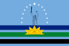
Flag[]
It was created by Julius Caesar Adrían, on July 10, 2002.

The meaning of the shapes and colors included in the Flag is as follows:
- Blue sky: It represents the sky.
- Stars: 13 rounded to the image of Joan the Advancer represent the 13 Municipalities and the big star in the center identifies the Capital Municipality.
- Green: Represents the soils, crops, mountains, forests and plains.
- Black: Represents the oil.
- The sun: Represents the aura, life and strength of the people and its seven points symbolize the 7 original districts that gave way to the 13 current municipalities. The black arch inside the sun represents the weapons of our indigenous people. The sun rises in the middle of the central strip (green) and its maximum height reaches the upper edge of the first strip.
*Sea blue: Represent Delta, Rivers, Lakes and Reservoirs.
Image: The image of Juana Ramirez La Avanzadora which represents the heroism of the Monaguense woman.
- Daggers: The daggers that cross at the bottom of the image of Juana La Avanzadora represent the brothers José Tadeo Monagas and José Gregorio Monagas, both heroes of the Republic. The stripes occupy 30% of the lower part of the separation between them is half the diameter of each strip.
Coat of Arms[]
The coat of arms of the State of Monagas is divided into two quarters: in the upper quarter, in a green field, there is a plow, a rake and a sickle, which are intertwined with a bundle of spikes, attributes of agriculture; and in the lower quarter, on the green field representing the plain, and blue background cut by the horizon, there is, in the shade of a large tree, a bull symbolizing breeding, and in the distance a galley of hills. A silver bar crosses diagonally through both barracks, and on it we read: "Resisted with courage". The extremities of four rifles placed in the pavilion, appear holding the Shield, and between the bayonets of these a horse head turned to the right of the Shield. Under and between the lower part of the rifles, there is a red and black ribbon, representative of the war to the death, and in it a broken key symbolizing that his capital was forced, but never surrendered. As an ornament they appear on the flanks of the Shield, between their crossed feet, a plain palm and a sugar cane stem.
Sports[]
 Monagas Sport Club (First Division of Venezuela)
 Embajadores de Monagas (Bolivarian National Baseball League)
 Cangrejeros de Monagas (National Basketball League)
 Elite Rugby Club Monagas (Venezuelan Rugby Club Championship)
Sports facilities[]
- Monagas has several teams that participate in Venezuela's national leagues, since 2007. It also has the largest state in the country, the Monumental Stadium of Maturin, built for the 2007 America's Cup.
- Maturín Sports Complex: It was built for the 1982 National Games. It has several facilities for the practice of sports such as basketball, soccer, minor baseball, indoor soccer, tennis, swimming, cycling and athletics. It is located in Raúl Leoni Avenue.
- Kartódromo de Viboral: place of motocross competition, karting and car tuning exhibitions at national level.
- San Miguel Country Club Golf Course: located in the north of the city.
Notable natives[]
From Amana of Tamarindo, town of Maturín municipality
- José Tadeo Monagas, general of the Venezuelan independence and president
From Barrancas
- , poet, novelist and journalist
From Caicara
- Manuel Núñez Tovar, doctor and entomologist
- , abogado criminólogo
- , educadora
From Caripe
- , poet

From Caripito
- Doris Wells, actress
- , artist
- , singer
- , poet
- Manny Trillo, professional baseball player
From Chaguaramal, town of Piar municipality
- Juana Ramírez (a.k.a. Juana la Avanzadora) heroine of the Venezuelan independence
- , general of the Venezuelan independence
From Guanaguana, town of Piar municipality
- , poet and novelist
From Maturín
- , general of the Venezuelan independence
- , musician, composer and dentist
- , musician
- , mathematician, teacher and historian
- Félix Armando Núñez, poet, teacher und dean of Chile's university
- , poet and teacher
- Eloy Palacios, sculptor
- , historian
- , poet and writer
From Musipán, town of Ezequiel Zamora municipality
- Benjamín Rausseo (a.k.a. Er Conde del Guácharo), television comedian
From San Antonio
- Julián Padrón, writer, journalist and lawyer
- William H. Phelps Jr., ornithologist and founder of RCTV
- , poet, novelist
- , dentist, teacher and poet
From Uracoa
- Mateo Manaure, painter, artist
- , journalist, lawyer, writer
Politics and government[]
Like the other 23 federal entities of Venezuela, the State maintains its own police force, which is supported and complemented by the National Police and the Venezuelan National Guard.

Monagas has the five branches of public power in Venezuela, and is autonomous and equal to the rest of the states of the Federation:
Executive Power[]
It is formed by the Governor of Monagas, and a cabinet of State Secretaries of his confidence who assist him in the management of the government and are officials of free appointment and removal, an attorney, autonomous institutes and state foundations.
Governors chosen in Popular Election
- . (1990–92); (1993–95) Acción Democrática
- . (1996–1998); (1999–2000) Acción Democrática
- Miguel Gómez. (2000) Movimiento Quinta República
- Guillermo Call. (2001–2004) Acción Democrática
- José Gregorio Briceño. (2004–2008) MIGATO, Movimiento Quinta República; (2009–2012) United Socialist Party of Venezuela
- Yelitza Santaella. (2012—2017) United Socialist Party of Venezuela.
Legislative Power[]
It consists of a unicameral parliament called the Legislative Council of the State of Monagas, which is responsible for approving the regional budget, passing state laws and supervising the management of the state governor.
Judiciary[]
It depends on the judiciary at the national level organized through the Judicial District of the State of Monagas.

Citizen Power[]
Formed by the State Moral Council and the State Comptroller General's Office, the latter being responsible for overseeing the proper use of the resources available to the regional government
Electoral power[]
It depends on the National Electoral Council at the national level that organizes the region through the so-called Main Electoral Board of the state of Monagas
State Constitution[]
Monagas is organized on the basis of the Constitution of the State of Monagas, adopted by the Legislative Council on 21 March 2002.
References[]
- ^ Añez, Jesimar (24 August 2021). "Cosme Arzolay sustituye a Yelitze Santaella en la Gobernación de Monagas" (in Spanish). El Pitazo. Retrieved 29 August 2021.
- ^ "Resultado Básico del XIV Censo Nacional de Población y Vivienda 2011 (Mayo 2014)" (PDF). Ine.gov.ve. p. 29. Retrieved 8 September 2015.
Sources[]
- González Oropeza, Hermann(1985): Historia del Estado Monagas. Ediciones Amon C.A., Caracas. (Biblioteca de Temas y Autores Monaguenses; Colección Guanipa; Ensayos e Investigaciónes)
See also[]
| Wikimedia Commons has media related to Monagas. |
| hide | ||
|---|---|---|
| Capital District | ||
| States | ||
| Federal Dependencies |
| |
| Regions |
| |
| Claimed | ||
| Authority control |
|
|---|
- Monagas
- States of Venezuela
- States and territories established in 1909