Mono Pass
| Mono Pass | |
|---|---|
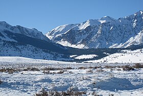 Mono Pass, winter, from the east | |
| Elevation | 3,230 m (10,597 ft) |
| Location | Yosemite National Park, border |
| Range | Sierra Nevada |
| Coordinates | 37°51′19.2″N 119°12′47.9″W / 37.855333°N 119.213306°WCoordinates: 37°51′19.2″N 119°12′47.9″W / 37.855333°N 119.213306°W |

Mono Pass is a mountain pass, just outside Yosemite National Park, near the region of Tuolumne Meadows. Mono Pass is between Mount Gibbs and .[1]
There is another pass also named Mono less than 40 miles away in the Rock Creek/Little Lakes Valley area. Both Mono Passes are in the Inyo National Forest. The Mono Pass in the Rock Creek/Little Lakes Valley area is accessed by the Mosquito Flats Trailhead rather than the Mono Pass Trailhead in Yosemite National Park.
Native history[]
When only Native Americans lived in the area, and for a time after, a major trading trail went over Mono Pass and through Bloody Canyon to Mono Lake, just to the east of the Yosemite area.[2][3][4][5][6]
The location of Mono Pass[]
Mono Pass is just outside of Yosemite National Park, though the trail starts along the Tioga Road 1.4 miles (2.3 km) south of the entrance, inside the park.[1]

As to hiking, there are a wealth of references.[7][1][8][9][10][6]
See also[]
References[]
- ^ a b c "Mono Pass Trail, Yosemite National Park". americansouthwest.net. Retrieved 1 February 2019.
- ^ "Yosemite Nature Notes" (PDF). yosemite.ca.us. October 1, 1953. Retrieved 1 February 2019.
- ^ "Scenic Vista Management Plan for Yosemite National Park" (PDF). NPS. July 1, 2010. Retrieved 1 February 2019.
- ^ Ewart, Dick (1978). "Mono Pass and Bloody Canyon". yosemite.ca.us. Retrieved 2 February 2019.
- ^ Gregory, Candace (September 3, 2017). "Hiking up to Mono Pass Trail's High Lakes". Hiking up to Mono Pass Trail’s High Lakes. sierranewsonline.com. Retrieved 2 February 2019.
- ^ a b Shannon, Betty (November 1, 1978). "The Mono Pass – Bloody Canyon Trail" (PDF). Owens Valley History. Retrieved 2 February 2019.
- ^ "Mono Pass". yosemite.com. Retrieved 1 February 2019.
- ^ Cary, Russ. "Yosemite Hikes Home » Tioga Pass Road » Mono Pass". yosemitehikes.com. Retrieved 1 February 2019.
- ^ Shields, Allan (1960). "Mono Pass and historic Golden Crown Mines". yosemite.ca.us. Retrieved 1 February 2019.
- ^ "Golden Crown Mine". NPS. March 1, 2015. Retrieved 2 February 2019.
- ^ "Ruby Peak, (0.7 mi SW of Ruby Lake)". summitpost.org. Retrieved 2 February 2019.
External links[]
- Yosemite National Park
- Mountain passes of the Sierra Nevada (United States)