Mont Giusalet
| Mont Giusalet | |
|---|---|
 | |
| Highest point | |
| Elevation | 3,312 m (10,866 ft) |
| Prominence | 835 m (2,740 ft)[1] |
| Isolation | 4.42 km (2.75 mi) |
| Listing | Alpine mountains above 3000 m |
| Coordinates | 45°11′00″N 06°56′00″E / 45.18333°N 6.93333°ECoordinates: 45°11′00″N 06°56′00″E / 45.18333°N 6.93333°E[1] |
| Geography | |
 Mont Giusalet Location in the Alps | |
| Location | Rhône-Alpes, France |
| Parent range | Cottian Alps |

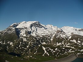
Mont Giusalet (3,313m - also called pointe du Clery) is a mountain in the Ambin group of the Cottian Alps in Savoie, France, near the Italian border.
Features[]
The mountain dominates the lower Susa Valley and the town of Susa in Italy, and can even be seen from a large area of the Po Valley.
The mountain, although lying on the Alpine watershed between the Val di Susa and the , is entirely in French territory following the boundary adjustments decided in the 1947 Treaty of Paris .
Mont Giusalet is rocky on its southern slopes and covered by a glacier on its northern one. With the two smaller peaks: Cime de Bard (3,150 m) and Punta della Vecchia (2993 m), it forms a small mountain massif. The mountain looks like a long ridge about a mile long going from east to west with two peaks at either end. On the eastern summit lies an Iron Cross.
References[]
- ^ a b "Mont Giusalet". Peakbagger.com. Retrieved 23 January 2015.
Sources[]
- Comptes rendus hebdomadaires des séances de l'Académie des sciences, Volume 151, publiés avec le concours Centre national de la recherche scientifique par MM. les secrétaires perpétuels, 1910; page 665 (online at books.google.fr, consulted in April 2013)
- Monte Giusalet m. 3313 Group of Ambin tab on www.altox.it (accessed April 2013)
Maps[]
- French official cartography (Institut géographique national - IGN); on-line version: www.geoportail.fr
- Istituto Geografico Centrale - Carta dei sentieri e dei rifugi 1:50.000 nr 2 Valli di Lanzo e Moncenisio
External links[]
- Mountains of the Alps
- Alpine three-thousanders
- Mountains of Savoie