Monte Caburaí
| Monte Caburaí | |
|---|---|
| Highest point | |
| Elevation | 1,465 m (4,806 ft) |
| Coordinates | 05°16′20″N 60°12′43″W / 5.27222°N 60.21194°WCoordinates: 05°16′20″N 60°12′43″W / 5.27222°N 60.21194°W |
| Geography | |
| Location | Roraima, Brazil - Guyana |

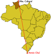
Location of Mount Caburaí in Brazil, in opposition to the country's southernmost point, Barra do Chuí.
Monte Caburaí is a mountain located on the border between the South American countries of Brazil and Guyana standing at 1,465 metres (4,806 ft) above sea level. The source of the or Ailã river, located on the mountain, is the northernmost point of Brazil.
See also[]
- Extreme points of Brazil
 | This Roraima, Brazil location article is a stub. You can help Wikipedia by . |
Categories:
- Mountains of Brazil
- Mountains of Guyana
- Brazil–Guyana border
- International mountains of South America
- Extreme points of Brazil
- Roraima geography stubs