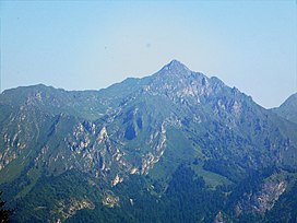
Monte Cadria
| Monte Cadria | |
|---|---|
 | |
| Highest point | |
| Elevation | 2,254 m (7,395 ft)[1][2] |
| Prominence | 1,434 m (4,705 ft)[1] |
| Isolation | 21.56 km (13.40 mi) |
| Coordinates | 45°56′23″N 10°41′50″E / 45.93972°N 10.69722°ECoordinates: 45°56′23″N 10°41′50″E / 45.93972°N 10.69722°E |
| Geography | |
 Monte Cadria Location in the Alps | |
| Location | Trentino-Alto Adige/Südtirol, Italy |
| Parent range | Garda Mountains |

Monte Cadria is a mountain in the Alps located in Italy. It is the highest peak of the Brescia and Garda Prealps.
Geography[]
Administratively the mountain belongs to the Italian region of Trentino Alto Adige/Südtirol and to the province of Trento.
SOIUSA classification[]
According to SOIUSA (International Standardized Mountain Subdivision of the Alps) the mountain can be classified in the following way:[3]
- main part = Eastern Alps
- major sector = Central Eastern Alps
- section = Brescia and Garda Prealps
- subsection = Prealpi Gardesane
- supergroup = Prealpi Giudicarie
- group = Gruppo del Cadria
- code = II/C-30.II-A.1
References[]
- ^ a b "Monte Cadria". Peakbagger.com. Retrieved 2012-05-16.[self-published source?]
- ^ Key col: Pradibondo (820 m)
- ^ Marazzi, Sergio (2005). Atlante Orografico delle Alpi. SOIUSA (in Italian). Priuli & Verlucca. p. 275. ISBN 978-88-8068-273-8.
External links[]
- Monte Cadria on www.summitpost.org
Categories:
- Two-thousanders of Italy
- Mountains of the Alps
- Mountains of Italy
- Garda Mountains