Monte Prado
| Monte Prado | |
|---|---|
 | |
| Highest point | |
| Elevation | 2,054 m (6,739 ft) |
| Prominence | 288 m (945 ft) |
| Isolation | 3.14 km (1.95 mi) |
| Coordinates | 44°15′00″N 10°24′27″E / 44.25000°N 10.40750°ECoordinates: 44°15′00″N 10°24′27″E / 44.25000°N 10.40750°E |
| Geography | |
 Monte Prado | |
| Parent range | Tuscan-Emilian Apennines |

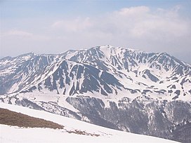
Monte Prado (or Prato) is a mountain in the northern Apennines, located in the trait between the and , with an altitude of 2,054 metres (6,739 ft).
Geography[]
Monte Prado is right on the boundary between the province of Reggio Emilia and that of Lucca.
Environment protection[]
The mountain is part of the National Park of the Appennino Tosco-Emiliano.[1]
See also[]
References[]
- ^ Cime, Ente Parco Nazionale Appennino Tosco-Emiliano web-page on www.parcoappennino.it
See also[]
This Tuscany location article is a stub. You can help Wikipedia by . |
Categories:
- Mountains of Emilia-Romagna
- Mountains of Tuscany
- Mountains of the Apennines
- Highest points of Italian regions
- Two-thousanders of Italy
- Tuscany geography stubs
- Emilia-Romagna geography stubs