Monte San Salvatore
| Monte San Salvatore | |
|---|---|
 | |
| Highest point | |
| Elevation | 912 m (2,992 ft) |
| Prominence | 602 m (1,975 ft)[1] |
| Isolation | 2.96 km (1.84 mi) |
| Coordinates | 45°58′37.3″N 8°56′50.1″E / 45.977028°N 8.947250°ECoordinates: 45°58′37.3″N 8°56′50.1″E / 45.977028°N 8.947250°E |
| Geography | |
 Monte San Salvatore Location in Switzerland | |
| Location | Ticino, Switzerland |
| Parent range | Lugano Prealps |
| Climbing | |
| Easiest route | Hike or ride Monte San Salvatore funicular |

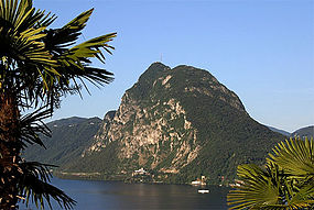
The Monte San Salvatore (912 m) is a mountain in the Lepontine Alps above Lake Lugano and the city of Lugano in Switzerland. The Monte San Salvatore funicular links the city with the summit of the mountain. The village on top of its peaks, Carona, is a popular destination to enjoy views over Lake Lugano and to walk through the exotic plants and flowers of Parco San Grato.[2]
Gallery[]
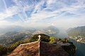
View of Lugano and its surroundings from Monte San Salvatore.

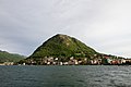
View of Lake Lugano from Monte San Salvatore, with Lugano to the left and the Melide causeway to the right
Monte San Salvatore, as seen from Piazza Luini, Lugano.

Monte San Salvatore at Night seen from Gandria


See also[]
References[]
- ^ Retrieved from the Swisstopo topographic maps. The key col is located between Noranco and Paradiso at 310 metres.
- ^ "TicinoTopTen - Parco San Grato".
External links[]
- Monte San Salvatore funicular railway web site
- Monte San Salvatore on Hikr
 Media related to Monte San Salvatore at Wikimedia Commons
| Authority control |
|---|
This Ticino location article is a stub. You can help Wikipedia by . |
Categories:
- Mountains of the Alps
- Mountains of Ticino
- Lepontine Alps
- Mountains of Switzerland
- Mountains of Switzerland under 1000 metres
- Ticino geography stubs