Montgomeryshire
| Montgomeryshire Welsh: Sir Drefaldwyn | |
|---|---|
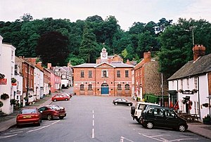 Broad Street and town hall in Montgomery (2001) | |
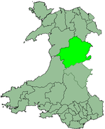
 Ancient extent of Montgomeryshire | |
| Area | |
| • 1831 | 483,323 acres (1,955.94 km2) |
| • 2011 | 537,000 acres (2,170 km2) |
| Population | |
| • 1831 | 66,482[1] |
| • 2011 | 63,779 |
| Density | |
| • 1831 | 0.1/acre |
| History | |
| • Succeeded by | Powys |
| Chapman code | MGY |
| Government | Montgomeryshire County Council (1889–1974) Montgomeryshire District Council (1974–1996) |
| • HQ | Montgomery |
Montgomeryshire, also known as Maldwyn (Welsh: Sir Drefaldwyn meaning "the Shire of Baldwin's town") is one of thirteen historic counties and a former administrative county of Wales. It is named after its county town, Montgomery, which in turn is named after one of William the Conqueror's main counsellors, Roger de Montgomerie, who was the 1st Earl of Shrewsbury.
Montgomeryshire today constitutes the northern part of the principal area of Powys. The population of Montgomeryshire was 63,779 according to the 2011 census,[2] with a low population density of just 75 people per square mile (29 people per square km). The current area is 2,174 square km (839 square miles).
The largest town is Newtown, followed by Welshpool and Llanidloes.
History[]

The Treaty of Montgomery was signed on 29 September 1267, in the town of Montgomery, which had recently been established as an English incursion on the Welsh side of the border, to control a strategic border crossing. The surrounding region (on the Welsh side of the border) otherwise comprised the mediaeval principality of Powys Wenwynwyn, the southern of the two states into which the Kingdom of Powys had been divided a century before.
Attacks by Gwynedd on Powys Wenwynwyn led the latter to seek the assistance of the English. Ultimately this led them to convert their territory into a marcher lordship, via surrender and regrant, as a way to strengthen their position; the ruling princes of Powys Wenwynwyn became the Lords of Powys, feudally bound to the English king, and able to fully rely on English backing, but otherwise independent. The prince took an English-style surname - Owen de-la Pole - after his capital city, Pool (now Welshpool).
With the introduction of the Laws in Wales Acts 1535–1542 the marcher lordships were converted into English counties. The Lordship of Powys - the former Powys Wenwynwyn - became Montgomeryshire; the county town being Montgomery, the strongest centre of English authority in the region, rather than centre of Welsh authority, Welshpool. Montgomeryshire was thus ultimately formed from the cantrefi of Powys Wenwynwyn:[3]
- Y Fyrnwy (commotes of Mochnant Uwch Rhaeadr, Mechain Is Coed and Llanerch Hudol)
- (commotes of Caereinion and Mechain Uwch Coed)
- Ystlyg (commotes of Deuddwr, Ystrad Marchell and Y Gorddwr Isaf)
- Cedewain (commotes of Cynan, Cyfeiliog and Mawddwy)
- Arwystli (commotes of Arwystli Is Coed and Arwystli Uwch Coed)
In addition, for practical reasons, Montgomeryshire gained the commote of Ceri, which had formed a northwards spur of the less organised region Between Wye and Severn; most of the rest of the latter region became Radnorshire.
Montgomeryshire was bordered, to the north, by Denbighshire, to the east and south east by Shropshire, to the south by Radnorshire, to the south west by Cardiganshire, and to the west and north west by Merionethshire. When, in subsequent centuries, the concept of Wales was once again officially distinguished from England, all of these counties were deemed Welsh, except for Shropshire. Montgomeryshire was the birthplace of Welsh Catholic martyr Saint Richard Gwyn (in 1537).
Local government[]
From 1889 to 1974 the county became an administrative county with a . Montgomery, the traditional county town, held the assizes and became the meeting place of the new County Council.[4] However, the administration continued to be based at Welshpool,[5] which prior to the reforms had been regarded as the county town.[6]
Local government reforms in 1974 combined the administrative areas of Montgomeryshire, Radnorshire and Breconshire together to form a new administrative Powys county. Montgomeryshire became a district of Powys, with its administrative headquarters in Newtown (and not Montgomery). Further local government reform in 1996 abolished district councils in Wales, making Powys a unitary authority. The Montgomeryshire area continued to have an administrative/political function as one of the three committee areas used by Powys Council to denote Powys's three historic counties (Montgomeryshire; Radnorshire and Breconshire), but these were abolished in 2018. In September 2019, The Brexit Party announced they would hold a referendum on restoring a County Council for Montgomeryshire, were they to enter Government in the Welsh Assembly. This would result in Montgomeryshire leaving Powys, and Powys being re-named Brecon and Radnor Council.
The few communities that were added to northern Powys in 1996 (which come within the historic boundaries of Denbighshire) now form part of the modern-day Montgomeryshire area.
Electoral representation[]
Montgomeryshire is a UK Parliament constituency and a Senedd constituency.
Geography[]
The shire is almost wholly mountainous, although there are some fertile valleys in the east. The highest point (county top) is Moel Sych at 826.7 metres (2,712 ft), whose summit lies at the triple county boundary point of Montgomeryshire, Denbighshire and Merionethshire in the Berwyn Mountains. The county top of Denbighshire, Cadair Berwyn at 832 metres (2,730 ft), is less than a kilometre away. Its main rivers are the River Severn (which flows east into Shropshire) and the River Dyfi (which flows west into the Irish Sea). Lake Vyrnwy is a reservoir supplying Liverpool.
The main towns are Machynlleth, Llanidloes, Montgomery, Newtown and Welshpool. The main industries are agriculture (mainly hill farming) and tourism, though there is also some forestry and light manufacturing. The population density is highest near the border with England and along the Severn valley. The county is closely linked to Shropshire, with many essential services for Montgomeryshire residents being located in the more densely populated town of Shrewsbury, such as acute health services at the Royal Shrewsbury Hospital.
The county flower of Montgomeryshire is Spergula arvensis (also called "corn spurrey"). The shire forms a vice-county for wildlife recording.
Transport[]
Montgomeryshire is crossed from East to West by the Cambrian Line, a mainline passenger railway which runs between Shrewsbury and Aberystwyth as well as Pwllheli with stations at Welshpool, Newtown, Caersws and Machynlleth. As of 2018 services are provided by Transport for Wales.
The Welshpool and Llanfair Light Railway links Welshpool to Llanfair Caereinion.
Places of special interest[]
- Bryntail lead mine buildings near Llanidloes
- Centre for Alternative Technology at Llwyngwern near Machynlleth
- The Museum of Modern Art, Wales (MOMA) in Machynlleth
- Dolforwyn Castle near Abermule
- Montgomery Castle in Montgomery
- The Old Bell Museum in Montgomery
- Powis Castle near Welshpool
- The Robert Owen Museum in Newtown
- Trefeglwys Tumuli
- Mathrafal — the seat of the Welsh kings and princes of Powys
- Meifod
- Offa's Dyke
Politics[]
Montgomeryshire is represented in the following constituencies:
- Montgomeryshire (UK Parliament constituency), a constituency of the House of Commons of the Parliament of the United Kingdom
- Montgomeryshire (Senedd constituency), a constituency of the Senedd (Welsh Parliament; Welsh: Senedd Cymru, formerly the National Assembly for Wales).
See also[]
- Townships in Montgomeryshire
- Local government in Wales
- History of Wales
- List of Lord Lieutenants of Montgomeryshire
- List of High Sheriffs of Montgomeryshire
References[]
- ^ Vision of Britain – 1831 Census
- ^ "Statistics about your area" (PDF). www.powys-i.org.uk. Retrieved 6 April 2018.
- ^ Cathrall, William (1828). The History of North Wales Volume II. Manchester. p. 290.
- ^ Wynford Vaughan-Thomas and Alun Llewelyn, The Shell Guide to Wales (Michael Joseph, London, 1974) p. 339
- ^ Vaughan-Thomas and Llewelyn, p. 339
- ^
External links[]
- Map of Montgomeryshire on Wikishire
Coordinates: 52°35′N 3°30′W / 52.583°N 3.500°W

| show Authority control |
|---|
- Montgomeryshire
- Historic counties of Wales
- States and territories established in 1535
- 1535 establishments in England