Morgan–Monchy Border Crossing
| Morgan–Monchy Border Crossing | |
|---|---|
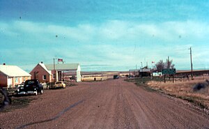 US Border Inspection Station at Morgan, Montana, as seen in 1985. This building was replaced in 2011. | |
| Location | |
| Country | United States; Canada |
| Location |
|
| Coordinates | 48°59′59″N 107°49′55″W / 48.999785°N 107.831863°WCoordinates: 48°59′59″N 107°49′55″W / 48.999785°N 107.831863°W |
| Details | |
| Opened | 1935 |
| US Phone | (406) 674-5248 |
| Canadian Phone | (306) 298-2232 |
| Hours | 9:00 AM-6:00 PM, 8:00 AM-9:00 PM (Summer only) |
| Website http://www.cbp.gov/contact/ports/whitlash | |

The Morgan–Monchy Border Crossing connects the town of Loring, Montana with Val Marie, Saskatchewan on the Canada–US border. It is reached by U.S. Route 191 on the American side and Saskatchewan Highway 4 on the Canadian side. This crossing is where the proposed Keystone Pipeline was to cross the border.
In 2011, the US replaced its border inspection facilities, which were originally built in 1963.[1] Canada replaced its inspection facilities, which were built in 1973, in 2015.
See also[]
References[]
- ^ "30-Day Review of Spending by U.S. Customs and Border Protection under the American Recovery and Reinvestment Act for Construction of Land Ports of Entry" (PDF). Department of Homeland Security. October 23, 2009. Retrieved 11 November 2015.
This Saskatchewan location article is a stub. You can help Wikipedia by . |
Categories:
- Canada–United States border crossings
- Geography of Saskatchewan
- 1935 establishments in Montana
- 1935 establishments in Saskatchewan
- Buildings and structures in Phillips County, Montana
- Saskatchewan geography stubs