Mosbytoppane
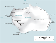
Map of Bouvetøya
Mosbytoppane[1] (earlier Mosbytoppen, sometimes anglicized as Mosby Peak), are two crags to the southwest of the caldera of the island of Bouvetøya. The tallest is a snow-covered peak 670 meters (2,200 ft) above mean sea level and 1.3 kilometers (0.81 mi) northeast of . It was charted by the in 1927–28, under Captain . It is named for Hakon Mosby, an oceanographer and meteorologist who was one of two scientists on the expedition.[2]
References[]
- ^ "Mosbytoppane". Norwegian Polar Institute. Archived from the original on 14 January 2014. Retrieved 12 May 2012.
- ^ "Mosby Peak". Geographic Names Information System. Archived from the original on 12 May 2012. Retrieved 12 May 2012.
Coordinates: 54°26′S 3°21′E / 54.433°S 3.350°E

This Bouvet Island location article is a stub. You can help Wikipedia by . |
Categories:
- Mountains of Bouvet Island
- Norway geography stubs
- Subantarctic island geography stubs