Mosenthein Island
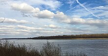
Mosenthein Island across the Mississippi River, as seen from the Missouri shore.

Aerial image showing Chouteau Island (green dot), Gabaret Island (blue dot), and Mosenthein Island (red dot)
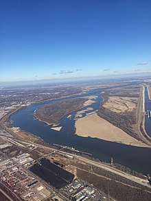
Another aerial view showing the three islands on the Mississippi River
Mosenthein Island, situated approximately eight miles (13 km) due north of the Gateway Arch in St. Louis, Missouri, and approximately one mile (1.6 km) south of the confluence of the Missouri River and Mississippi River, is one of a cluster of three islands: Chouteau Island, Gabaret Island, and Mosenthein Island.[1] Mosenthein Island is 1,077 acres in area.[1][2] The island is mainly bottomland forest.[2] It is only accessible by boat.[1][2]
References[]
- ^ a b c "Economic Development - Enterprise Zone Details". City of Madison, Illinois. Archived from the original on 2017-02-22. Retrieved 2017-02-22.
- ^ a b c "Hunter Fact Sheets". Illinois DNR. 2017-02-22. Retrieved 2017-02-22.
Coordinates: 38°43′21″N 90°12′06″W / 38.72250°N 90.20167°W

This St. Louis location article is a stub. You can help Wikipedia by . |
Categories:
- Islands of the Mississippi River
- River islands of Illinois
- St. Louis geography stubs