Moswetuset Hummock
Moswetuset Hummock | |
 the size Moswetuset Hummock | |
 | |
| Location | E. Squantum Street, near jct. with Quincy Shore Drive, Quincy, Massachusetts |
|---|---|
| Coordinates | 42°17′22″N 71°1′18″W / 42.28944°N 71.02167°WCoordinates: 42°17′22″N 71°1′18″W / 42.28944°N 71.02167°W |
| NRHP reference No. | 70000094 |
| Added to NRHP | July 01, 1970 |


Moswetuset Hummock is a Native American site and the original name of the tribe (now Massachusetts) in the region. The wooded hummock in Squantum, Massachusetts, is formally recognized as historic by descendants of the Ponkapoag people.
The location was the seat of the ruling Moswetuset Sac'hem (Native American Chief) Chickatawbut and where he would carry out tribal council during the warm season. Members of the Moswetuset (Massachusett) tribe for centuries made the shore of Quincy Bay their seasonal home.
Moswetuset Hummock is understood to be the site where Chickatawbut negotiated with Plymouth Colony commander Myles Standish and Tisquantum, a Patuxet tribe guide. In 1617 an epidemic, probably a disease brought on a visiting European ship, ravaged the native population here and along the New England coastline. Estimates are that 80% of the people died. By the time of King Philip's War, 1675–77, little presence of the Moswetuset tribe remained in the town. However, descendants of these original inhabitants still live in the general area today.
In his 1747 volume A History of New-England historian Daniel Neal described Moswetuset Hummock as the origin of the name of the indigenous Massachusett tribe, and thus the name of the Commonwealth of Massachusetts:[1][2]
The Sachem or Sagamore who governed the Indians in this part of the country when the English came hither, had his seat on a small hill, or hummock, containing perhaps an acre and a half, about two leagues to the southward of Boston, which hill or hummock lies in the shape of an Indian's arrowhead, which arrow-heads are called in their language MOS, or MONS, with O nasal, and hill in their language is WETUSET hence, this great sachem's seat was called Moswetuset, which signifies a hill in the shape of an arrow's head, and his subjects, the Moswetuset Indians, from whence with a small variation of the word, the Province received the name MASSACHUSETTS.
Moswetuset translates to 'shaped like an arrowhead'.
In 1970 it was formally recognized and also added to the United States National Register of Historic Places in Massachusetts.[3] The historic site is recognized by both the United States National Register as well as the Native American descendants, the Ponkapoag people. Moswetuset Hummock is located on East Squantum Street, the northern end of Wollaston Beach, Quincy Bay.
A hummock is a geological term, are small by definition, and less than fifty feet in height. Earth hummocks, in contrast to ice hummocks; are also known as a small rounded knoll, mound of land, or a hillock. Hummocks are believed to be relict features that were formed under colder conditions when permafrost was likely present in the ground. [4]
Gallery[]

Moswetuset Hummock Commemorative Marker

Moswetuset Hummock Shape
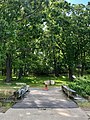
Moswetuset Hummock Bridge

Moswetuset Hummock Rock

Moswetuset Hummock East
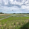
Moswetuset Hummock North

Ponkapoag Tribe


See also[]
References[]
- ^ "East Squantum Street (Moswetuset Hummock)". Quincy, Mass. Historical and Architectural Survey. Thomas Crane Public Library. 1986. Retrieved 2009-06-24.
- ^ Neal, Daniel (1747). "XIV: The Present State of New England". The history of New-England. Vol. 2 (2 ed.). London: Printed for A. Ward. p. 216. OCLC 8616817. Retrieved 2009-06-24.
- ^ "National Register Information System". National Register of Historic Places. National Park Service. April 15, 2008.
- ^ Bates, Robert L. and Julia A. Jackson, ed. (1984). "hummock." Dictionary of Geological Terms, 3rd Ed. New York: Anchor Books. p. 241.
External links[]
- The Massachusett Tribe at Ponkapoag
- Discover Quincy: Moswetuset
- Massachusetts State Park/ Quincy Shore Reservation details
- Department of Conservation and Recreation
| Topics |  | ||||||||||||||||
|---|---|---|---|---|---|---|---|---|---|---|---|---|---|---|---|---|---|
| Lists by county | |||||||||||||||||
| Lists by city |
| ||||||||||||||||
| Other lists | |||||||||||||||||
| |||||||||||||||||
- National Register of Historic Places in Quincy, Massachusetts
- Quincy, Massachusetts
- Geography of Norfolk County, Massachusetts
- Protected areas of Norfolk County, Massachusetts
- Tourist attractions in Quincy, Massachusetts
- Norfolk County, Massachusetts Registered Historic Place stubs