Motagua Fault
| Motagua Fault | |
|---|---|
| Motagua Fault Zone | |
 | |
| Location | Guatemala and Mexico |
| Tectonics | |
| Plate | North American Plate, Caribbean Plate |
| Status | Active |
| Earthquakes | 1717, 1773, 1902, 1976, 1980, 2009 |
| Type | transform fault |
The Motagua Fault (also, Motagua Fault Zone) is a major, active left lateral-moving transform fault which cuts across Guatemala, continuing offshore along the southern Pacific coast of Mexico, returning onshore along the southernmost tip of Oaxaca, then continuing offshore until it merges with the Middle America Trench near Acapulco. It forms part of the tectonic boundary between the North American Plate and the Caribbean Plate. It is considered the onshore continuation of the Swan Islands Transform Fault which runs under the Caribbean Sea.[citation needed]
The Motagua Fault is regarded by some geologists as part of a system of faults designated the "Motagua-Polochic system" rather than as a discrete single boundary. The Polochic fault (also referred to as the Chixoy-Polochic Fault) lies north and parallel to the Motagua Fault and shares some of the motion between the North American and Caribbean Plates.[citation needed]
Earthquakes[]
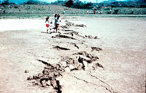
The Motagua Fault has been responsible for several major earthquakes in Guatemala's history, including the 7.5 Mw Guatemala 1976 earthquake, and is also notable for its significant visible fault trace.[1]
References[]
Coordinates: 15°08′N 89°22′W / 15.133°N 89.367°W

External links[]
- Seismic faults of Guatemala
- Seismic faults of Mexico
- Strike-slip faults
- Earthquakes in Guatemala
- Geographic areas of seismological interest
- Pacific Coast of Mexico