Motutaiko Island
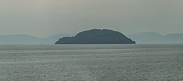 Motutaiko Island as seen from Tauranga Taupo | |
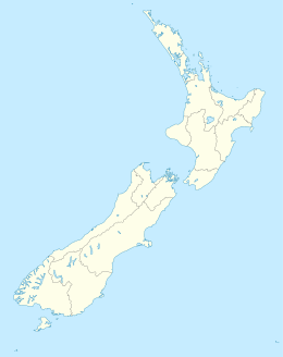 Motutaiko Island Motutaiko Island's location within New Zealand | |
| Geography | |
|---|---|
| Location | Lake Taupō |
| Coordinates | 38°51′14″S 175°56′31″E / 38.854°S 175.942°ECoordinates: 38°51′14″S 175°56′31″E / 38.854°S 175.942°E |
| Area | 11 ha (27 acres) |
| Length | 400 m (1300 ft) |
| Width | 550 m (1800 ft) |
| Coastline | 1,500 m (4900 ft) |
| Highest elevation | 600 m (2000 ft) |
| Administration | |


Motuaiko Island is an island within Lake Taupō on the North Island of New Zealand. The lake's only island, it sits near the town of Motutere.
Natural features[]
Motutaiko is formed out of a column of rhyolitic lava, connected to the geologic systems of Lake Taupō. The island was likely formed after an underwater magma vent's releases cooled and hardened into a cone, with Motutaiko forming the apex.[1]
Several endangered species live on the island, including Wainuia clarki. Other animals present on the island include small skinks and a colony of cormorants.[2]
Maori tradition[]
The island is spiritually significant to the Māori people, and landing on the island is therefore prohibited by the government.[3] , a major chief of the Ngāti Tūwharetoa, was buried in a sacred cave on the island in the 18th century.[2]
The taniwha of Lake Taupō, Horomatangi, is said to live in a cave on the island's northeastern face.[1] The creature is also said to be the pet of Ngātoro-i-rangi.[3]
Name[]
The name Motutaiko is from the Māori language, with motu meaning island, and taiko being a name for the black petrel (Procellaria parkinsoni).[4]
References[]
- ^ a b Stout, Sir Robert. "Lake Taupo". NZTEC. Retrieved 4 October 2020.
- ^ a b "Motutaiko Island". NZ DOC. Archived from the original on 4 March 2014. Retrieved 4 October 2020.
- ^ a b "Motutaiko Island / Places of significant interest in Taupo". Living Heritage. Retrieved 4 October 2020.
- ^ "Motutaiko Island". gazetteer.linz.govt.nz. Retrieved 20 January 2022.
- Islands of Waikato
- Volcanic islands
- Taupo District
- Māori mythology
- Lake Taupo