Mouila
Mouila | |
|---|---|
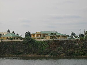
 Presidential residence in Mouila | |
 Coat of arms | |
 Mouila Location in Gabon | |
| Coordinates: 1°51′50″S 11°3′27″E / 1.86389°S 11.05750°ECoordinates: 1°51′50″S 11°3′27″E / 1.86389°S 11.05750°E | |
| Country | |
| Province | Ngounié Province |
| Department | Douya-Onoy Department |
| Population | |
| • Total | 36,000 |
Mouila is the capital of the Ngounié region of Gabon. It lies on the Ngounié River and the N1 road and has a population of about 20,000 people. Its main sight is , a lake known for its bright blue water.
Mouila is very spread out and has several markets and commercial centers. A taxi service runs in Mouila. Taxis are green and white and cost 200–500 Central African CFA francs depending on the distance traveled.
Mouila is home to a huge range of Gabonese ethnic groups and is a major hub of commerce and travel. It is served by Mouila Airport. From Mouila, bush taxis may be obtained traveling to Ndende, Tchibanga, Lambaréné, Libreville and Lebamba.
Climate[]
Mouila has a tropical savanna climate (Köppen climate classification Aw).
| hideClimate data for Mouila | |||||||||||||
|---|---|---|---|---|---|---|---|---|---|---|---|---|---|
| Month | Jan | Feb | Mar | Apr | May | Jun | Jul | Aug | Sep | Oct | Nov | Dec | Year |
| Average high °C (°F) | 31.3 (88.3) |
32.0 (89.6) |
32.1 (89.8) |
32.2 (90.0) |
31.0 (87.8) |
28.3 (82.9) |
27.3 (81.1) |
27.6 (81.7) |
29.4 (84.9) |
30.8 (87.4) |
30.9 (87.6) |
30.7 (87.3) |
30.3 (86.5) |
| Daily mean °C (°F) | 28.8 (83.8) |
27.3 (81.1) |
27.3 (81.1) |
27.5 (81.5) |
26.9 (80.4) |
24.8 (76.6) |
23.7 (74.7) |
24.1 (75.4) |
25.6 (78.1) |
26.7 (80.1) |
26.7 (80.1) |
26.6 (79.9) |
26.3 (79.3) |
| Average low °C (°F) | 26.2 (79.2) |
22.5 (72.5) |
22.5 (72.5) |
22.7 (72.9) |
22.8 (73.0) |
21.3 (70.3) |
20.0 (68.0) |
20.6 (69.1) |
21.8 (71.2) |
22.5 (72.5) |
22.4 (72.3) |
22.5 (72.5) |
22.3 (72.1) |
| Average precipitation mm (inches) | 223.4 (8.80) |
226.4 (8.91) |
249.3 (9.81) |
239.9 (9.44) |
165.7 (6.52) |
20.4 (0.80) |
5.4 (0.21) |
7.9 (0.31) |
51.3 (2.02) |
342.3 (13.48) |
397.1 (15.63) |
231.3 (9.11) |
2,160.4 (85.06) |
| Average precipitation days | 15.5 | 13.3 | 16.2 | 15.2 | 13.2 | 2.9 | 3.5 | 4.4 | 8.8 | 20.5 | 21.4 | 15.6 | 150.5 |
| Average relative humidity (%) | 82 | 80 | 80 | 82 | 82 | 83 | 82 | 81 | 79 | 80 | 81 | 82 | 81 |
| Source: NOAA[1] | |||||||||||||
Notable people[]
- François Bozizé, a former president of the Central African Republic, is from Mouila.
- Pierre Mamboundou, politician
- André Raponda Walker, the anthropologist and priest worked near here at a place called Sainte-Martin.[2]
References[]
- ^ "Mouila Climate Normals 1961–1990". National Oceanic and Atmospheric Administration. Retrieved 8 March 2015.
- ^ Biography of Raponds Walker, accessed 11 August 2008
| Rank | Name | Province | Pop. | ||||||
|---|---|---|---|---|---|---|---|---|---|
 Libreville  Port-Gentil |
1 | Libreville | Estuaire | 703,940 | |||||
| 2 | Port-Gentil | Ogooué-Maritime | 136,462 | ||||||
| 3 | Franceville | Haut-Ogooué | 110,568 | ||||||
| 4 | Owendo | Estuaire | 79,300 | ||||||
| 5 | Oyem | Woleu-Ntem | 60,685 | ||||||
| 6 | Moanda | Haut-Ogooué | 59,154 | ||||||
| 7 | Ntoum | Estuaire | 51,954 | ||||||
| 8 | Lambaréné | Moyen-Ogooué | 38,775 | ||||||
| 9 | Mouila | Ngounié | 36,061 | ||||||
| 10 | Akanda | Estuaire | 34,548 | ||||||
Categories:
- Populated places in Ngounié Province
