Mount Ashitaka
| Mount Ashitaka | |
|---|---|
 Southeast Side | |
| Highest point | |
| Peak | Mount Echizen-dake |
| Elevation | 1,504 m (4,934 ft) |
| Dimensions | |
| Length | 7 km (4.3 mi) Southwest-Northeast |
| Width | 6 km (3.7 mi) Northwest-Southeast |
| Naming | |
| Native name | 愛鷹山 (Japanese) |
| Geography | |
| Country | Japan |
| Prefecture | Shizuoka |
| Range coordinates | 35°13′37″N 138°48′11″E / 35.227°N 138.803°ECoordinates: 35°13′37″N 138°48′11″E / 35.227°N 138.803°E |
 Ashitaka Mount Ashitaka (Japan) | |

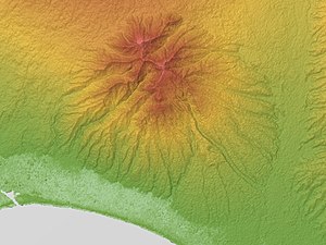
Mount Ashitaka (愛鷹山, Ashitakayama) is an eroded stratovolcano in the area south-east of Mount Fuji, Japan. Its highest peak, 1,504 metres (4,934 ft) high,[1] is Mount Echizen-dake, but the complex is named after its secondary peak, , 1,188 m (3,898 ft) high.
Detailed map[]
Gallery[]

From the south.

From above

From Mount Fuji


See Also[]
- List of volcanoes in Japan
- List of mountains in Japan
References[]
- ^ Karátson, D. "Erosion calderas: origins, processes, structural and climatic control," Bulletin of Volcanology Vol. 61 (1999), pp. 179 [PDF 6 of 20]; Retrieved 2012-6-21.
The page incorporated material from Japanese Wikipedia page 愛鷹山, accessed 23 April 2019
External links[]
- "Ashitaka". Global Volcanism Program. Smithsonian Institution. Retrieved 25 June 2021.
- Ashitaka Yama - Geological Survey of Japan
| Authority control |
|
|---|
This Japanese location article is a stub. You can help Wikipedia by . |
Categories:
- Extinct volcanoes
- Izu–Bonin–Mariana Arc
- Lava domes
- Mountains of Shizuoka Prefecture
- Pleistocene volcanoes
- Stratovolcanoes of Japan
- Subduction volcanoes
- Volcanoes of Honshū
- Japan geography stubs