Mount Cabuyao
| Mount Cabuyao | |
|---|---|
| Mount Kabuyao | |
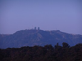 Mount Kabuyao with the landmark two satellite dishes on its summit | |
| Highest point | |
| Elevation | 2,025 m (6,644 ft)[1] |
| Coordinates | 16°21′23″N 120°33′32.8″E / 16.35639°N 120.559111°ECoordinates: 16°21′23″N 120°33′32.8″E / 16.35639°N 120.559111°E |
| Geography | |
 Mount Cabuyao | |
| Country | Philippines |
| Region | Cordillera Administrative Region |
| Province | Benguet |
| City/municipality | Tuba |
| Parent range | Cordillera Central |
| Climbing | |
| Easiest route | Hike |


Mount Cabuyao (alternatively spelled as Mount Kabuyao) is a mountain in the Philippines located in the municipality of Tuba in the province of Benguet. Its summit, rising to more than 2,000 metres (6,600 ft) above sea level,[1][2] overlooks the city of Baguio. It is commonly mistaken as Mount Santo Tomas, a taller mountain just beside it.[1]
Due to its high elevation, several communications companies constructed relay stations and radars at the summit.[3] A private observatory and AA radar station, once operated by the US Armed Forces stationed in the country, is also located here. A water catchment area was constructed to supply water to the City of Baguio and nearby towns. A small community of farmers live at the top of the mountain.[4] A town hall and a school was built for them by the local government.
Tourism[]

Currently, no tourists are allowed to visit here because of the Permanent Environment Protection Order issued by the Court of Appeals on May 5, 2015.
Previously, the two large satellite dishes at its summit have become a landmark for Baguio City.[1][5] The summit is also a good vantage point. During fair weather, one can see the whole City of Baguio to the east and could partially see the province of Pangasinan to the west. On a clear day, one can observe moving cargo ships passing by the South China Sea.
Hikers climb the mountain occasionally for recreational purposes.[1] Biking is also popular.[2]
Forest cover[]
The mountain forest is part of the protected Mount Santo Tomas watershed, which supplies water to areas near the Ben Palispis Highway and other parts of Tuba.[6] In September 2014, the Supreme Court of the Philippines ordered the temporary ceasing of development projects in a disputed area covering the forest reserve.[7][8] [9] The affected area, which has been heavily deforested, was to be developed into an eco-tourism park, as planned by Baguio City Representative Nicasio Aliping Jr.[6][7][8][9][10]
References[]
- ^ a b c d e "Mt. Cabuyao (2,025 +) / Mt. Sto. Tomas (2,256 +)". Pinoy Mountaineer. 19 April 2008. Retrieved 30 September 2014.
- ^ a b Tupaz, Voltaire (6 May 2012). "Bikers race to raise funds for Cordillera forests". Rappler. Retrieved 30 September 2014.
- ^ "List of Field Stations, Northern Luzon PRSD". PAGASA. Archived from the original on 6 October 2014. Retrieved 30 September 2014.
- ^ "La Trinidad mayor wants more farmers to engage in strawberry production". DWDD (1134 kHz Metro Manila). 5 March 2014. Archived from the original on 6 October 2014. Retrieved 1 October 2014.
- ^ "Mt. Cabuyao Troposcatter Dishes". Vista Pinas. 11 July 2010. Retrieved 1 October 2014.
- ^ a b Lacsamana, Hanna (1 June 2014). "Mt Kabuyao diggings seen to defile springs". Baguio Midland Courier. Retrieved 1 October 2014.
- ^ a b Aning, Jerome (30 September 2014). "SC stops activities in Mt. Santo Tomas forest". Philippine Daily Inquirer. Retrieved 1 October 2014.
- ^ a b Merueñas, Mark (30 September 2014). "SC stops road project in Benguet for now". GMA News. Retrieved 1 October 2014.
- ^ a b "Seeing The Damage Done In Cabuyao/Sto. Tomas Is Shocking: And That's Putting It Mildly". Cordillera Sun. 16 July 2014. Retrieved 1 October 2014.
- ^ Fontanilla, Giovani Joy (31 August 2014). "Chronicling Kabuyao's destruction". Sun.Star Baguio. Retrieved 1 October 2014.
This article about a location in the Cordillera Administrative Region is a stub. You can help Wikipedia by . |
- Mountains of the Philippines
- Landforms of Benguet
- Philippines geography stubs