Mount Delabarre
| Mount Delabarre | |
|---|---|
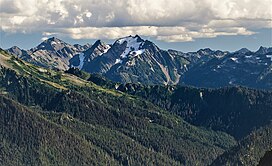 Ice-clad Delabarre, north aspect | |
| Highest point | |
| Elevation | 6,024 ft (1,836 m)[1] |
| Prominence | 1,140 ft (350 m)[1] |
| Parent peak | Mount Christie (6,181 ft)[2] |
| Isolation | 2.56 mi (4.12 km)[2] |
| Coordinates | 47°41′11″N 123°29′36″W / 47.68625°N 123.49339°WCoordinates: 47°41′11″N 123°29′36″W / 47.68625°N 123.49339°W[1] |
| Naming | |
| Etymology | W. R. Delabarre |
| Geography | |
 Mount Delabarre Location of Mt. Delabarre in Washington | |
| Location | Olympic National Park Jefferson County, Washington, US |
| Parent range | Olympic Mountains |
| Topo map | USGS Chimney Peak |
| Geology | |
| Age of rock | Eocene |
| Climbing | |
| First ascent | Unknown[1] |
| Easiest route | class 3 scrambling[1] |


Mount Delabarre is a remote 6,024-foot (1,836-metre) mountain summit located deep within Olympic National Park in Jefferson County of Washington state. Part of the Olympic Mountains, Mount Delabarre is situated 12.4 miles southeast of Mount Olympus, and is set within the Daniel J. Evans Wilderness. The nearest higher neighbor is line parent Mount Christie, 2.5 miles to the west-northwest.[3] Precipitation runoff from the mountain drains north into headwaters of Delabarre Creek, which is a tributary of the Elwha River, and south into Rustler Creek, which is a tributary of the North Fork Quinault River. Topographic relief is significant as the southwest aspect of the peak rises 3,400 feet (1,036 m) above Rustler Creek in approximately one mile.
History[]
The mountain is named after W. R. Delabarre, the Port Angeles banker who provided financial assistance for The Mountaineers' 1907 exploration into the Olympic Mountains, which included the first ascent of Mount Olympus.[4] At a later time, Delabarre and Asahel Curtis scouted a different trail to Mt. Olympus, and in the course of their journey, the men crossed the stream that would later officially bear his name.[5][6]
The mountain is also called "Mount Taylor",[1] but neither name has been officially adopted by the United States Board on Geographic Names, so the peak is not labelled on USGS maps.
Two scramble routes to the summit have been established: via Martins Park trail, and via Godkin-Rustler Pass.[1]
Climate[]
Based on the Köppen climate classification, Mount Delabarre is located in the marine west coast climate zone of western North America.[7] Most weather fronts originate in the Pacific Ocean, and travel east toward the Olympic Mountains. As fronts approach, they are forced upward by the peaks of the Olympic Range, causing them to drop their moisture in the form of rain or snowfall (Orographic lift). As a result, the Olympics experience high precipitation, especially during the winter months. During winter months, weather is usually cloudy, but, due to high pressure systems over the Pacific Ocean that intensify during summer months, there is often little or no cloud cover during the summer. The months July and August offer the most favorable weather for climbing this mountain.[1]
Geology[]
The Olympic Mountains are composed of obducted clastic wedge material and oceanic crust, primarily Eocene sandstone, turbidite, and basaltic oceanic crust.[8] The mountains were sculpted during the Pleistocene era by erosion and glaciers advancing and retreating multiple times.
See also[]
References[]
- ^ a b c d e f g h Mount Delabarre, climbersguideolympics.com
- ^ a b "Delabarre, Mount - 6,024' WA". listsofjohn.com. Retrieved 2022-01-11.
- ^ "Mount Delabarre, Washington". Peakbagger.com.
- ^ Olympic Mountain Rescue, Olympic Mountains: A Climbing Guide, 4th Edition, 2006, Mountaineers Books, ISBN 9780898862065, page 206.
- ^ Parratt, Smitty (1984). Gods and Goblins: A Field Guide to Place Names of Olympic National Park (1st ed.).
- ^ "Delabarre Creek". Geographic Names Information System. United States Geological Survey. Retrieved 2022-01-11.
- ^ Peel, M. C.; Finlayson, B. L.; McMahon, T. A. (2007). "Updated world map of the Köppen−Geiger climate classification". Hydrol. Earth Syst. Sci. 11: 1633–1644. ISSN 1027-5606.
- ^ Alt, D.D.; Hyndman, D.W. (1984). Roadside Geology of Washington. pp. 249–259. ISBN 0-87842-160-2.
External links[]
- "Olympic National Park". National Park Service. Archived from the original on 2022-01-04.
- Weather forecast
- Aerial photo: PBase
- Aerial photo: Flickr
Places adjacent to Mount Delabarre | ||||||||||||||||
|---|---|---|---|---|---|---|---|---|---|---|---|---|---|---|---|---|
| ||||||||||||||||
- Olympic Mountains
- Mountains of Washington (state)
- Mountains of Jefferson County, Washington
- Landforms of Olympic National Park
- North American 1000 m summits