Mount Denjō
| Mount Denjō | |
|---|---|
| 殿城山 | |
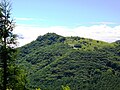
 Mount Denjō from near the top | |
| Highest point | |
| Elevation | 1,800 m (5,900 ft) |
| Listing | List of mountains and hills of Japan by height |
| Coordinates | 36°6′N 138°12′E / 36.100°N 138.200°E |
| Naming | |
| Language of name | Japanese |
| Pronunciation | [dendʑoːsaɴ] |
| Geography | |
| Location | Nagawa, Nagano, Japan |
| Parent range | |

Mount Denjō (殿城山, Denjō-san) is a 1,800 m (5,906 ft) mountain of , located in Nagawa, Nagano. This mountain is a part of the Yatsugatake-Chūshin Kōgen Quasi-National Park.
Leisure[]
On Mount Denjō, there is .
Route[]
There are several routes to the top of the mountain. The easiest route is to climb from . Other routes are from or Mount Ōsasa.
Access[]
- of
Gallery[]

Mount Denjō from near the top (08/2008)
At the top of Mount Denjō (08/2008)

Kawara-Nadeshiko at the top of Mount Denjō (08/2008)

A Forest of Mount Denjō (08/2008)

Mount Denjō from Echo Valley Ski Resort(08/2009)
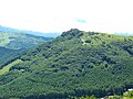
Mount Denjō from Mount Ōsasa(08/2009)
Mount Denjo from Mount Kitanomimi (08/2009)
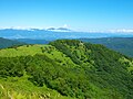
Mount Denjō with Mount Asama from Mount Kuruma(08/2009)


References[]
- Official Home Page of the Geographical Survey Institute in Japan
- ‘Yatsugatake, Tateshina, Utsukushigahara, Kirigamine 2008, Shobunsha
| Wikimedia Commons has media related to Mount Denjō. |
Categories:
- Mountains of Nagano Prefecture