Mount Diablo meridian

Summit beacon tower atop Mt. Diablo. The initial point marker lies within this tower.
The Mount Diablo meridian, established in 1851, is a principal meridian extending north and south from its initial point atop Mount Diablo in California at W 121° 54.845. Established under the U.S. Public Land Survey System, it is used to describe lands in most of northern California and all of Nevada.[1] Mount Diablo also marks the baseline at latitude 37°52′54″N.[2]
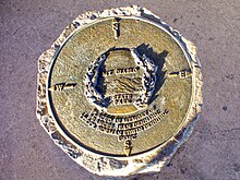
Mount Diablo Memorial Marker
See also[]
References[]
- ^ *John W. Pettley, PLS. "Mount Diablo Survey Point Establishes Property Boundaries in California and Nevada". Mount Diablo Surveyors Historical Society. Retrieved 2012-09-27.
- ^ *"Mount Diablo Meridian". U.S. Bureau of Land Management. Archived from the original on 2017-01-06. Retrieved 2012-09-27.
External links[]
- "Mount Diablo Meridian, San Francisco, CA". Principal Meridian Project. Retrieved 2012-09-27.
- "Cadastral Survey: Principal Meridians and Base Lines". U.S. Bureau of Land Management. Archived from the original on 2012-10-18. Retrieved 2012-09-27.
Coordinates: 37°52′54″N 121°54′51″W / 37.88167°N 121.91417°W

This Contra Costa County, California–related article is a stub. You can help Wikipedia by . |
Categories:
- Meridians and base lines of the United States
- Mount Diablo
- Named meridians
- Northern California
- Geography of California
- 1851 establishments in California
- Contra Costa County, California geography stubs