Mount Lamborn
| Mount Lamborn | |
|---|---|
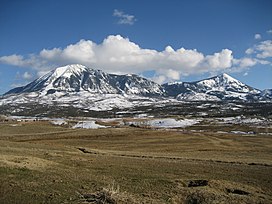 View of Mount Lamborn (left) and Landsend Peak (right) from Lamborn Mesa, near Paonia, Colorado | |
| Highest point | |
| Elevation | 11,402 ft (3,475 m)[1][2] |
| Prominence | 1,616 ft (493 m)[3] |
| Isolation | 2.39 mi (3.85 km)[3] |
| Listing | Colorado county high points 40th |
| Coordinates | 38°48′10″N 107°31′22″W / 38.8029015°N 107.5228458°WCoordinates: 38°48′10″N 107°31′22″W / 38.8029015°N 107.5228458°W[1] |
| Geography | |
 Mount Lamborn Colorado | |
| Location | High point of Delta County, Colorado, United States[3] |
| Parent range | West Elk Mountains[3] |
| Topo map | USGS 7.5' topographic map Paonia, Colorado[4] |

Mount Lamborn is a mountain summit in the West Elk Mountains range of the Rocky Mountains of North America. The 11,402-foot (3,475 m) peak is located in Gunnison National Forest, 5.9 miles (9.5 km) southeast by south (bearing 141°) of the Town of Paonia in Delta County, Colorado, United States. The summit of Mount Lamborn is the highest point in Delta County.[1][2][3][4] Together with nearby Landsend Peak to the southwest, it lies at the western edge of the West Elks, rising dramatically nearly 6,000 ft (1,800 m) above the valley of the North Fork Gunnison River to the west.
Mountain[]
Mount Lamborn is an eroded igneous intrusion that geologists call a laccolith.
See also[]
- List of mountain peaks of Colorado
- List of Colorado county high points
References[]
- ^ Jump up to: a b c "LAMBORN". NGS data sheet. U.S. National Geodetic Survey. Retrieved October 20, 2014.
- ^ Jump up to: a b The elevation of Mount Lamborn includes an adjustment of +1.648 m (+5.41 ft) from NGVD 29 to NAVD 88.
- ^ Jump up to: a b c d e "Mount Lamborn, Colorado". Peakbagger.com. Retrieved October 20, 2014.
- ^ Jump up to: a b "Mount Lamborn". Geographic Names Information System. United States Geological Survey. Retrieved November 15, 2014.
External links[]
Mount Lambornat Wikipedia's sister projects
 Definitions from Wiktionary
 Media from Wikimedia Commons
 News from Wikinews
 Quotations from Wikiquote
 Texts from Wikisource
 Textbooks from Wikibooks
 Resources from Wikiversity
| show |
|---|
| show |
|---|

| show |
|---|
This Colorado state location article is a stub. You can help Wikipedia by . |
Categories:
- West Elk Mountains
- Mountains of Delta County, Colorado
- Landforms of Delta County, Colorado
- Gunnison National Forest
- Mountains of Colorado
- North American 3000 m summits
- Colorado geography stubs