Mount Peres
| Mount Peres | |
|---|---|
| تل الفرس (in Arabic) הר פֶּרֶס (in Hebrew) | |
 | |
| Highest point | |
| Elevation | 929 m (3,048 ft) |
| Coordinates | 32°57′34″N 35°51′50″E / 32.95944°N 35.86389°ECoordinates: 32°57′34″N 35°51′50″E / 32.95944°N 35.86389°E |
| Geography | |
 Mount Peres Location in the Golan Heights | |
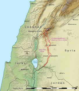
| Location | Golan Heights |
| Parent range | Peres mountain range |
| Geology | |
| Mountain type | Volcano |

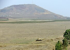
Mount Peres (Arabic: تل الفرس, Tall al-Faras, Hebrew: הר פֶּרֶס, Har Peres) is a volcanic mountain located in central Golan Heights, some 5.5 kilometres (3.4 mi) east of Moshav Keshet.[1] Its highest point is 929 metres (3,048 ft) above sea level, or about 200 metres (660 ft) above ground level. The mountain is the southernmost of a series of dormant volcanoes that stretch up to the northern parts of the Golan Heights. On top of the mountain is a well-preserved crater, 200 meters in diameter and 35 metres (115 ft) deep.
References[]
| Authority control |
|
|---|
This geography of Israel article is a stub. You can help Wikipedia by . |
Categories:
- Mountains of the Golan Heights
- Volcanoes of the Golan Heights
- Israel geography stubs