Mount Ruang
| Ruang | |
|---|---|
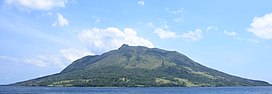 Ruang from the island of Tagulandang | |
| Highest point | |
| Elevation | 725 m (2,379 ft)[1] |
| Listing | Spesial Ribu |
| Coordinates | 2°18′N 125°22′E / 2.30°N 125.37°E |
| Geography | |
| Location | Sangihe Islands, Indonesia |
| Geology | |
| Mountain type | stratovolcano |
| Last eruption | September 2002 |

Ruang is the southernmost stratovolcano in the Sangihe Islands arc. It comprises an island 4 × 5 km wide. The summit contains a partial lava dome, and reaches some 2,379 ft in altitude. From its summit, Klabat's peak in the south, that of Siau to the north, and Ternate to the east can all be seen.[2]
Eruptions[]
The first recorded eruption was in 1808.[1] Dr. Adolf Meyer witnessed a large eruption in 1871. Ruang was uninhabited at the time, but the inhabitants of nearby Tagulandang had many plantations on its slopes. The eruption destroyed these in minutes and caused a tsunami that obliterated most of their large village, situated on Tagulandang, opposite Ruang. Most of the village's inhabitants drowned, and their bodies could afterwards be seen on the beach.[2]
See also[]
References[]
- ^ Jump up to: a b "Ruang". Global Volcanism Program. Smithsonian Institution. Retrieved 2021-06-24.
- ^ Jump up to: a b Rowley, G. D. (1877). Ornithological Miscellany. 2. London: Taylor and Francis. pp. 324–325.
| Wikimedia Commons has media related to Mount Ruang. |
- Stratovolcanoes of Indonesia
- Mountains of Indonesia
- VEI-4 volcanoes
- Active volcanoes of Indonesia