Mount Sir Wilfrid Laurier
| Mount Sir Wilfrid Laurier | |
|---|---|
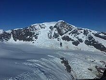
 South face of Mount Sir Wilfrid Laurier | |
| Highest point | |
| Elevation | 3,516 m (11,535 ft)[1][2] |
| Prominence | 2,728 m (8,950 ft)[1][2] |
| Parent peak | Mount Clemenceau[2] |
| Listing |
|
| Coordinates | 52°48′05″N 119°43′54″W / 52.80139°N 119.73167°WCoordinates: 52°48′05″N 119°43′54″W / 52.80139°N 119.73167°W[3] |
| Geography | |
 Mt. Sir Wilfrid Laurier | |
| Parent range | Premier Range |
| Topo map | NTS 83D13 Kiwa Creek[3] |
| Climbing | |
| First ascent | July 5, 1924 by Allen Carpe, Rollin Chamberlin, & A. Withers[4] |

Mount Sir Wilfrid Laurier is the highest peak of the Cariboo Mountains in the east-central interior of British Columbia, Canada. The mountain is part of the Premier Range, which is located just west of Valemount.
The name honours the seventh Prime Minister of Canada, Sir Wilfrid Laurier, who died in 1919. Originally named "Mount Titan" by American mountaineer Allen Carpe, it was officially renamed in 1929 to honour Canada's Liberal prime minister.[4]
See also[]
References[]
- ^ Jump up to: a b "British Columbia and Alberta: The Ultra-Prominence Page". Peaklist.org. Retrieved 2012-07-04.
- ^ Jump up to: a b c "Mount Sir Wilfrid Laurier". Bivouac.com. Retrieved 2018-01-07.
- ^ Jump up to: a b "Mount Sir Wilfrid Laurier". BC Geographical Names. Retrieved 2018-01-07.
- ^ Jump up to: a b Scott, Chic (2000). Pushing the Limits, The Story of Canadian Mountaineering. Calgary, AB, Canada: Rocky Mountain Books. pp. 95. ISBN 0-921102-59-3.
External links[]
Mount Sir Wilfrid Laurierat Wikipedia's sister projects
 Definitions from Wiktionary
 Media from Wikimedia Commons
 News from Wikinews
 Quotations from Wikiquote
 Texts from Wikisource
 Textbooks from Wikibooks
 Resources from Wikiversity
Categories:
- Three-thousanders of British Columbia
- Cariboo Mountains
- Regional District of Fraser-Fort George