Mount Sis
| Mount Sis | |
|---|---|
 Mount Sis | |
| Highest point | |
| Elevation | 2,182 m (7,159 ft) |
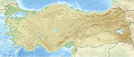
| Coordinates | 40°53′0″N 39°6′0″E / 40.88333°N 39.10000°ECoordinates: 40°53′0″N 39°6′0″E / 40.88333°N 39.10000°E |
| Geography | |
| Location | Görele, Giresun Province, Turkey |

Mount Sis (Turkish: Sis Dağı) is a mountain in Görele, Giresun Province, Turkey. Its elevation is 2182 m (7159 ft). Mount Sis Festival (Turkish: Sis Dağı Şenlikleri) attracts hundreds of people from Giresun and Trabzon to visit Mount Sis.[1][2] During the festival, traditional costumes are worn by visitors. The first Mount Sis Festival is thought to be held in 1830s.[3] Mount Sis has also a plateau which is called "Sis Dağı Yaylası" in Turkey.
See also[]
References[]
- ^ "Archived copy". Archived from the original on 2009-02-17. Retrieved 2011-04-15.
{{cite web}}: CS1 maint: archived copy as title (link) - ^ "Archived copy". Archived from the original on 2012-02-25. Retrieved 2011-04-15.
{{cite web}}: CS1 maint: archived copy as title (link) - ^ "Archived copy". Archived from the original on 2011-05-11. Retrieved 2011-04-15.
{{cite web}}: CS1 maint: archived copy as title (link)
External links[]
This article about a Black Sea Region of Turkey location is a stub. You can help Wikipedia by . |
Categories:
- Mountains of Turkey
- Landforms of Giresun Province
- Black Sea Region geography stubs