Mount Somers / Te Kiekie
| Mount Somers | |
|---|---|
 Mount Somers from | |
| Highest point | |
| Elevation | 1,688[1] m (5,538 ft) |
| Listing | List of mountains of New Zealand by height |
| Coordinates | 43°37′9.39″S 171°22′27.81″E / 43.6192750°S 171.3743917°ECoordinates: 43°37′9.39″S 171°22′27.81″E / 43.6192750°S 171.3743917°E |
| Naming | |
| Native name | Te Kiekie (Māori) |
| Geography | |
 Mount Somers South Island, New Zealand | |
| Parent range | Southern Alps |
| Climbing | |
| Easiest route | Mount Somers Summit Track |

Mount Somers / Te Kiekie is a mountain in the South Island of New Zealand, located in the foothills of the Southern Alps. At 1,688 metres (5,538 ft), it is prominently visible from the Canterbury Plains. The area around the mountain offers opportunities for day walks and overnight tramping.
Etymology[]
The mountain's Māori name, Te Kiekie, refers to a chief who arrived on the Āraiteuru canoe.[2] The European name was given by the surveyor of the Canterbury Association, Captain Joseph Thomas, and recorded on his 1849 map of Canterbury. Like most names assigned by Thomas, it commemorates a member of the Canterbury Association, in this case the banker and MP Thomas Somers-Cocks (1815–1899).[3]
The mountain's European name was later used for a settlement, Mount Somers, and then a branch line railway, the Mount Somers Branch. The settlement is 10 kilometres (6.2 mi) south of the mountain's summit.[1]
Geology and botany[]
Most of the hills in the Mid Canterbury area is made up of greywacke. Mount Somers / Te Kiekie is of volcanic origin, though. There are fault lines visible, columns, and cooling fractures. Especially to the east of the mountain, there are viable deposits of silica, sand, limestone, and coal.[4]
Soils have poor fertility. Some areas form plateaus and combined with high rainfall, the area is ideal for plants that prefer boggy conditions.[4]
Tramping in the area[]
The area's coal deposits were first discovered in 1856, which let to the founding of the village Mount Somers. A tramline was built to get the coal to the village. Mining for coal stopped in 1954.[4] The route of the tramline is now part of the tramping track called Miners Track that goes from the Woolshed Creek car park to Woolshed Creek Hut. The walk to Woolshed Creek Hut via Miners Track is one of the best known tramps in Mid Canterbury.[5] A more challenging route to Woolshed Creek Hut is via the Rhyolite Ridge Track past an overhang which is named the Bus Stop.[6]
The Mt Somers Walkways Society formed in 1983, made up by locals from Mount Somers and Staveley. Their aim was to create a circular track around the mountain and the Mt Somers Track was officially opened in 1987.[7] In the late 2000s,[a] a tramping shelter was added to the southern part of the track and this saw the official completion of the project. That tramping shelter is named Acland shelter, is located above Mount Somers Station, and is named for the original European owner of the land – John Acland.[8][9] Mount Somers / Te Kiekie itself can be reached via the southern part of the Mt Somers Track. It can be reached starting from either the Woolshed Creek car park, or the Sharplin Fall car park. The Mt Somers Summit Track is the side track to the summit; as it is located on the south face of the mountain, it gets very icy in winter and is then difficult to climb.[7]
Mt Somers Track starts and finishes at Sharplin Falls car park. The northern part of the circuit follows Bowyers Stream for a while. A once popular destination, Sharplin Falls (on Bowyers Stream), closed in February 2015 after rockfall took out that part of the track that was built as a gantry on a rock face. Two years later, the Department of Conservation announced that the closure of the side track to Sharplin Falls would be permanent.[10] Mt Somers Track, after following Bowyers Stream for some distance, reaches Pinnacles Hut. The hut was named for the rock formation behind it on the north face of Mount Somers / Te Kiekie. The track then climbs over Mount Somers saddle before it descends to Woolshed Creek Hut. From the hut, the track ascends to the overhand known as the Bus Stop. It then continues via the Acland Shelter along the south face of Mount Somers / Te Kiekie and climbs up onto Staveley Hill, the point where the Mt Somers Summit Track starts. From Staveley Hill, the track descends towards the Sharplin Falls car park.[7]
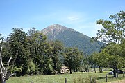
Mount Somers / Te Kiekie seen from Staveley
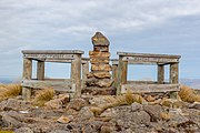
Summit of Mount Somers / Te Kiekie

Woolshed Creek Hut

Pinnacles Hut
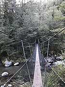
Halfway Bridge over Bowyers Stream
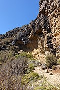
Mt Somers Track at the Bus Stop Overhang

Sharplin Falls


Footnotes[]
- ^ The article is undated but refers to a past event in October 2006, and was written during the reign of Ashburton mayor Bede O'Malley, who was mayor until October 2010.
References[]
- ^ a b "NZ Topo Map". NZ Topo Map. Retrieved 27 July 2020.
- ^ Reed, A. W. (2010). Peter Dowling (ed.). Place Names of New Zealand. Rosedale, North Shore: Raupo. p. 369. ISBN 9780143204107.
- ^ Thomas, Joseph (1849). Sketch map of the country intended for the settlement of Canterbury (map). Canterbury. Retrieved 27 July 2020.
- ^ a b c "Mount Somers area". Department of Conservation. Retrieved 26 July 2020.
- ^ James, Nathan (11 July 2019). "Woolshed Creek Hut". Adventures from the South. Retrieved 27 July 2020.
- ^ "Woolshed Creek Hut". Department of Conservation. Retrieved 27 July 2020.
- ^ a b c "Mt Somers Track" (PDF). Department of Conservation. September 2014. Retrieved 27 July 2020.
- ^ Jensen, Mick. "Shelter 'covered' and a piece of history preserved". Ashburton Online. Retrieved 27 July 2020.
- ^ "Multiple income streams flow from hill country farm". Radio New Zealand. 1 March 2019. Retrieved 27 July 2020.
- ^ Cavanagh, Liam (12 February 2017). "Sharplin Falls Track to be shut permanently following rockfall, DOC says". Stuff. Retrieved 27 July 2020.
External links[]
- Southern Alps
- Mountains of Canterbury, New Zealand
- Ashburton District