Mount Tō
| Mount Tō | |
|---|---|
| 塔ノ岳 | |
 Mount Tō from Mount Maru | |
| Highest point | |
| Elevation | 1,490.9 m (4,891 ft) |
| Coordinates | 35°27′N 139°9′E / 35.450°N 139.150°E |
| Naming | |
| Language of name | Japanese |
| Pronunciation | [toːnodake] |
| Geography | |
| Location | On the border of Kiyokawa, Hadano and Yamakita in Kanagawa, Japan |
| Parent range | Tanzawa Mountains |

Mount Tō (塔ノ岳, Tō-no-dake) is a 1,490.9 m (4,891 ft) mountain of Tanzawa Mountains, located on the border of Kiyokawa, Hadano and Yamakita in Kanagawa, Japan.
Outline[]
Mount Tō is one of the most popular mountains in Tanzawa Mountains. This mountain is a part of Tanzawa-Ōyama Quasi-National Park with other Tanzawa Mountains.
Access[]
- of
Gallery[]
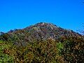
Mount Tō from Ōkura-one (10/2008)
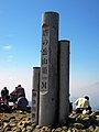
At the top of Mount Tō (10/2008)

Religious objects at the top of Mount Tō (10/2008)

Mount Hiru and Mount Fudō from Mount Tō (10/2008)
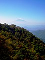
Mount Fuji from Mount Tō (10/2008)

Mount Ōyama from Mount Tō (10/2008)
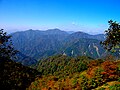
Northwest side view from Mount Tō (10/2008)

An entrance of Mount Tō (10/2008)


References[]
Categories:
- Mountains of Kanagawa Prefecture
- Kiyokawa, Kanagawa
- Hadano, Kanagawa
- Yamakita, Kanagawa