Mount Telomoyo
| Mount Telomoyo | |
|---|---|
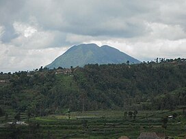 Mount Telomoyo seen from Ketep Pass | |
| Highest point | |
| Elevation | 1,894 m (6,214 ft)[1] |
| Coordinates | 7°22′S 110°24′E / 7.37°S 110.40°E |
| Geography | |
| Geology | |
| Age of rock | Holocene |
| Mountain type | Stratovolcano |
| Last eruption | Unknown |


The road to Mount Telomoyo
Mount Telomoyo is a stratovolcano in Central Java, Indonesia. The volcano was constructed over the southern flank of the eroded Pleistocene-age Soropati volcano, which has a height of 1,300 metres (4,300 ft).[2] The Soropati volcano collapsed during the Pleistocene, leaving a U-shaped depression. Mount Telomoyo grows on the southern side of the depression, reaching over 600 metres (2,000 ft) above the depression's rim.[1]
See also[]
References[]
- ^ Jump up to: a b "Telomoyo". Global Volcanism Program. Smithsonian Institution. Retrieved 2006-12-26.
- ^ http://www.volcano.si.edu/world/volcano.cfm?vnum=0603-231&volpage=synsub
| Wikimedia Commons has media related to Mount Telomoyo. |
This Central Java location article is a stub. You can help Wikipedia by . |
Categories:
- Stratovolcanoes of Indonesia
- Mountains of Central Java
- Volcanoes of Central Java
- Central Java geography stubs