Mount Tengu
| Mount Tengu | |
|---|---|
| 天狗岳 | |
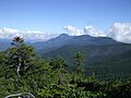
 Mount Tengu from west | |
| Highest point | |
| Elevation | 2,646 m (8,681 ft) |
| Listing | List of mountains and hills of Japan by height |
| Coordinates | 36°01′09″N 138°21′20″E / 36.01917°N 138.35556°ECoordinates: 36°01′09″N 138°21′20″E / 36.01917°N 138.35556°E |
| Naming | |
| Language of name | Japanese |
| Pronunciation | [teŋɡudake] |
| Geography | |
| Location | On the border of Chino and Koumi of Nagano in Japan |
| Parent range | Northern Yatsugatake Volcanic Group |
| Geology | |
| Mountain type | Stratovolcano |

Mount Tengu (天狗岳, Tengu-dake) is a 2,646m mountain on the border of Chino and Koumi of Nagano in Japan. This mountain is the highest mountains of Northern Yatsugatake Volcanic Group. Named for the mythical avian creatures of Japanese folklore, the Tengu.
Description[]
Mount Tengu is a stratovolcano. This mountain is a part of the Yatsugatake-Chūshin Kōgen Quasi-National Park. This mountain is on the list of the . This mountain has two major peaks, Mount Higashi Tengu, and Mount Nishi Tengu.
Access[]
- of Suwa Bus
Gallery[]

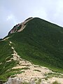
Mount Tengu from Mount Iō

Mount Nishi-Tengu (Left) and Mount Higashi-Tengu from Mount Neishi
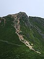
Mount Nishi-Tengu from Mount Higashi-Tengu
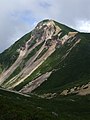
Mount Higashi-Tengu from Mount Nishi-Tengu
Mount Nishi-Tengu from Mount Neishi

Kuroyuri-daira, north of Mount Tengu
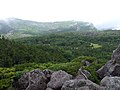
Kuroyuri-daira, north of Mount Tengu
Mount Tateshina from Mount Tengu

Hida Mountains from Mount Tengu


References[]
- Mountains of Nagano Prefecture
- Volcanoes of Nagano Prefecture
- Stratovolcanoes of Japan
- Pleistocene volcanoes