Mount Washington, Cincinnati
This article needs additional citations for verification. (May 2013) |
Mount Washington | |
|---|---|
 Mount Washington is a neighborhood of Cincinnati, Ohio. |
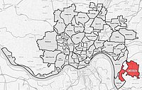
Mount Washington is a community on the east side of Cincinnati, Ohio, United States. As one of Cincinnati's 52 neighborhoods, Mount Washington lies within the city corporation limits, and borders the neighborhoods of California and the East End, as well as unincorporated Anderson Township, Hamilton County, Ohio. It is served by the 24, 30X, and 81X Metro[1] bus routes.
The population was 11,711 at the 2010 census.[2]
History[]
Mount Washington was laid out in 1846 and received its city rights in 1867. The community was annexed by the City of Cincinnati in 1911.[3][4]
Business district[]

Mount Washington is home to numerous small businesses, many of them located along Beechmont Avenue / Ohio State Route 125 in the main neighborhood business district, "The Mount Washington Water Tower District" is sometimes referred to as "Uptown" as a means of distinguishing it from other business districts, including Downtown Cincinnati and the two other districts in Mount Washington.
Businesses include Water Tower Fine Wines (a retail wine shop with weekly tastings and appetizers), Ramundo's Pizza, Sweets & Meats BBQ (a locally owned award-winning take out restaurant), Mt. Washington Creamy Whip & Bakery, Mt. Washington Jewelry, Mr. Lock locksmith, and several salons, as well as local outlets of Wendy's, LaRosa's Pizza, Fifth Third Bank, Walgreens, and Kroger (headquartered in Cincinnati). Gold Star Chili was started in Mount Washington with the purchase of Hamburger Heaven in 1965, although the original location no longer exists. A recipe for Cincinnati chili was included in the sale.
Community organizations[]
Mt. Washington Community Council (MWCC) is the official representative voice of the neighborhood to the City of Cincinnati. MWCC ensures that neighborhood development responds to the needs and goals of its citizens. MWCC is also a vehicle for communication and engagement.[5] Public meetings are held the third Wednesday of every month at the Mt. Washington Recreation Center.[6]
The Mt. Washington Community Urban Redevelopment Corporation[7] represents the member businesses in the neighborhood. Mt. Washington is also served by an active American Legion, Post 484,[8] and Masonic Lodge, Yeatman Lodge #162[9]
Beechmont Avenue reconstruction and evolution[]
Beechmont Avenue in western Mount Washington, prior to the 2002-2003 widening, featured reversible lanes. When the street was widened, two additional lanes were added between the western Corporation Line and Wasigo Drive (to create a dual turn lane), with one additional lane between Wasigo Drive and Corbly Street. Sidewalks, trees and curbs were also added along the route as well as a bike lane into the business district.
Schools[]
Three grade schools are located in Mount Washington:
- Sands Montessori (Corbly Street, Cincinnati Public Schools), a magnet school now housed in a new building (2011) on the site formerly housing the Eastern Hills Elementary and Junior High Schools
- Mt. Washington Elementary School (Mears Avenue, Cincinnati Public Schools), a neighborhood school offering a state-of-the-art Expiditionary Learning program for students, with a high-quality pre-school program rating five stars on the Step Up to Quality scale from the .
- Guardian Angels School (6539 Beechmont Avenue, Roman Catholic Archdiocese of Cincinnati). The Guardian Angels Campus, constructed in 1931, 1942, 1949, and 1963–1971, was designed by architect Edward J. Schulte.
The Archbishop McNicholas High School (Roman Catholic Archdiocese of Cincinnati) is also located in Mount Washington, across from Guardian Angels.
Mount Washington is also home to the Athenaeum of Ohio (Mt. St. Mary's Seminary of the West), located at the eastern gateway to Mount Washington, the intersection of Beechmont Avenue and Burney Lane. The campus is owned by the Archdiocese of Cincinnati and is known for its architecture. Many of the records for the Archdiocese of Cincinnati are located at the campus library. It is common to see the Franciscan Monks walking or riding their bikes, barefoot, throughout the neighborhood.
Parks[]
Cincinnati Park Board operates the 125-acre (0.51 km2) on Oxford Avenue between Corbly Street and Crestview Place. This park is named after Brigadier General , who was the highest-ranking officer from Hamilton County in World War I. The Tudor-style Stanbery house used to be located on park grounds, but was demolished as part of a park improvement program.
The park facilities include a paved walking area, hiking trails, playground equipment, and a picnic shelter.
Mt. Washington Cemetery is located on Sutton Ave.
Community events[]

Three large festivals are held throughout the year in Mt. Washington. Guardian Angels Church conducts a large church festival in the summer, complete with games, food, live music and gambling. The Pumpkin Chuck, produced by the Mt. Washington Community Council, is held the first Saturday after Halloween. The highlight of this festival is the three hand-built trebuchets, while launch pumpkins into the ravine. The Holiday Walk, produced by MWCURC, is held the first Saturday after Thanksgiving. Businesses offer free activities and games for families, choirs from local schools perform, free carriage rides are offered, Santa takes pictures with children, and a ceremonial lighting of the Mt. Washington Water Tower ends the event.
An Independence Day parade is held each year, on a route going through the business district on Beechmont Ave.
Additionally, Sands Montessori has a large carnival held in the fall, and the American Legion Post 484 has a carnival the first weekend in August.
References[]
- ^ Metro
- ^ "Mt. Washington Statistical neighborhood approximation". City of Cincinnati. p. 2. Retrieved 27 January 2018.
- ^ Federal Writers' Project (1943). Cincinnati, a Guide to the Queen City and Its Neighbors. p. 249. ISBN 9781623760519. Retrieved 2013-05-04.
- ^ Clarke, S. J. (1912). "Cincinnati, the Queen City, 1788-1912, Volume 2". The S. J. Clarke Publishing Company. p. 528. Retrieved 2013-05-20.
- ^ http://choosecincy.com/Community-Development/Community-Resources/Community-Councils.aspx
- ^ http://www.mwcc.org/events/
- ^ Mt. Washington Community Urban Redevelopment Corporation
- ^ American Legion, Post 484
- ^ Yeatman Lodge #162
External links[]
Coordinates: 39°05′15″N 84°23′11″W / 39.08750°N 84.38639°W


- Neighborhoods in Cincinnati
- Former municipalities in Ohio