Mount Yufu
This article does not cite any sources. (June 2021) |
| Mount Yufu | |
|---|---|
| 由布岳 | |
 SW side | |
| Highest point | |
| Elevation | 1,583.3 m (5,195 ft) |
| Listing | List of mountains and hills of Japan by height |
| Coordinates | 33°16′56″N 131°23′24″E / 33.28222°N 131.39000°E |
| Naming | |
| Language of name | Japanese |
| Pronunciation | [juɸudake] |
| Geography | |
| Topo map | Geographical Survey Institute 25000:1 別府西 |
| Geology | |
| Mountain type | Stratovolcano |


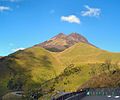
Mount Yufu (由布岳, Yufudake) is a 1,583.3 m (5,195 ft) volcano, located on the border of Yufu and Beppu, Ōita, Japan.
Outline[]

Relief map of Yufu Volcano (Left) & Tsurumi Volcano (Center)
Mount Yufu is a stratovolcano. It has two peaks, called ‘Higashi-mine’ (East Peak) and ‘Nishi-mine’ (West Peak). Nishi-mine is about one meter higher than Higashi-Mine.
See also[]
- List of islands in Japan
- List of volcanoes in Japan
- List of mountains in Japan
Route[]
The most popular route is from of . It takes two and half hours. There are other routes from Yufu City and .
Gallery[]
SSW side

S side

Viewed from Mt. Tsurumi

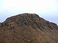
Collapsed section
West Peak

East Peak
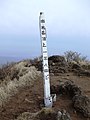
The summit


References[]
External links[]
| Wikimedia Commons has media related to Mount Yufu. |
- Yufudake - Japan Meteorological Agency (in Japanese)
- Yufudake: National catalogue of the active volcanoes in Japan - Japan Meteorological Agency
- Yufu Dake - Geological Survey of Japan
- "Yufu-Tsurumi". Global Volcanism Program. Smithsonian Institution. Retrieved 2021-06-24.
Categories:
- Volcanoes of Kyushu
- Mountains of Ōita Prefecture
- Volcanoes of Ōita Prefecture
- Stratovolcanoes of Japan