Mourão
Mourão | |
|---|---|
 | |
 Flag  Coat of arms | |
 | |
| Coordinates: 38°20′N 7°22′W / 38.333°N 7.367°WCoordinates: 38°20′N 7°22′W / 38.333°N 7.367°W | |
| Country | |
| Region | Alentejo |
| Intermunic. comm. | Alentejo Central |
| District | Évora |
| Parishes | 3 |
| Government | |
| • President | Maria Clara Safara (PS) |
| Area | |
| • Total | 278.63 km2 (107.58 sq mi) |
| Population (2011) | |
| • Total | 2,663 |
| • Density | 9.6/km2 (25/sq mi) |
| Time zone | UTC±00:00 (WET) |
| • Summer (DST) | UTC+01:00 (WEST) |
| Local holiday | February 2 |
| Website | http://www.cm-mourao.pt |

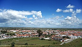
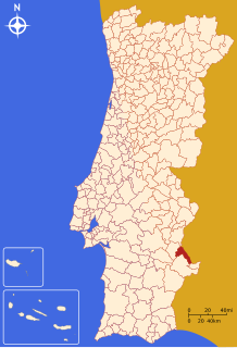
Mourão (Portuguese pronunciation: [mowˈɾɐ̃w] (![]() listen)) is a municipality in the District of Évora in Portugal. The population in 2011 was 2,663,[1] in an area of 278.63 km².[2]
listen)) is a municipality in the District of Évora in Portugal. The population in 2011 was 2,663,[1] in an area of 278.63 km².[2]
Geography[]
The municipality borders the municipality of Alandroal to the north, Spain to the east, Barrancos to the south-east, Moura to the south and Reguengos de Monsaraz to the east.
The town has the well-preserved Castle of Mourão.
Gallery[]

Mourão Castle

Street in Mourão

View of the Alqueva Dam from the castle


Politics[]
The present Mayor is Maria Clara Safara, elected by the Socialist Party. The municipal holiday is February 2.
Parishes[]
Administratively, the municipality is divided into 3 civil parishes (freguesias):[3]
- Granja
- Luz
- Mourão
Notable people[]
- Hernâni Neves (born 1963) a retired Portuguese footballer and beach soccer player, known as Hernâni
See also[]
- Granja Amareleja IPR
References[]
- ^ Instituto Nacional de Estatística
- ^ "Áreas das freguesias, concelhos, distritos e país". Archived from the original on 2018-11-05. Retrieved 2018-11-05.
- ^ Diário da República. "Law nr. 11-A/2013, page 552 79" (pdf) (in Portuguese). Retrieved 28 July 2014.
External links[]
| Authority control |
|---|
This Évora location article is a stub. You can help Wikipedia by . |
Categories:
- Municipalities of Évora District
- Portugal geography stubs