Mourjou
Mourjou | |
|---|---|
Part of Puycapel | |
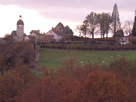 Mourjou seen from Jalenques, during an autumn evening | |
show Location of Mourjou | |
 Mourjou | |
| Coordinates: 44°41′29″N 2°19′48″E / 44.6914°N 2.33°ECoordinates: 44°41′29″N 2°19′48″E / 44.6914°N 2.33°E | |
| Country | France |
| Region | Auvergne-Rhône-Alpes |
| Department | Cantal |
| Arrondissement | Aurillac |
| Canton | Maurs |
| Commune | Puycapel |
| Area 1 | 29.99 km2 (11.58 sq mi) |
| Population (2017)[1] | 321 |
| • Density | 11/km2 (28/sq mi) |
| Time zone | UTC+01:00 (CET) |
| • Summer (DST) | UTC+02:00 (CEST) |
| Postal code | 15340 |
| Elevation | 294–663 m (965–2,175 ft) (avg. 480 m or 1,570 ft) |
| 1 French Land Register data, which excludes lakes, ponds, glaciers > 1 km2 (0.386 sq mi or 247 acres) and river estuaries. | |


Mourjou (Languedocien: Morjon, or Morjó) is a former commune in the Cantal department in south-central France. On 1 January 2019, it was merged into the new commune Puycapel.[2] A chestnut fair is held annually during the third weekend of October.
The village is home to the Maison de la Chataigne, a museum dedicated to the chestnut: its history, its cultivation and harvesting, and its consumption. It is open from June to September every day of the week in the afternoon, except Monday.
Population[]
| Year | Pop. | ±% |
|---|---|---|
| 1793 | 1,046 | — |
| 1821 | 1,119 | +7.0% |
| 1841 | 1,115 | −0.4% |
| 1856 | 1,163 | +4.3% |
| 1872 | 1,062 | −8.7% |
| 1886 | 1,017 | −4.2% |
| 1901 | 860 | −15.4% |
| 1911 | 864 | +0.5% |
| 1921 | 759 | −12.2% |
| 1936 | 746 | −1.7% |
| 1946 | 658 | −11.8% |
| 1962 | 592 | −10.0% |
| 1975 | 543 | −8.3% |
| 1982 | 503 | −7.4% |
| 1990 | 420 | −16.5% |
| 1999 | 354 | −15.7% |
| 2008 | 327 | −7.6% |
| 2011 | 311 | −4.9% |
See also[]
External links[]
- Official website of the Commune of Mourjou
- Foire de la Chataigne
- Maison de la Chataigne
- Auberge de Mourjou
- Historical Information (in French)
References[]
- ^ Téléchargement du fichier d'ensemble des populations légales en 2017, INSEE
- ^ Arrêté préfectoral 12 December 2018 (in French)
| Wikimedia Commons has media related to Mourjou. |
This Cantal geographical article is a stub. You can help Wikipedia by . |
Categories:
- Former communes of Cantal
- Populated places disestablished in 2019
- Cantal geography stubs