
Mud village, Spiti
Mud
Mudh | |
|---|---|
village | |
 Mud village above Pin river, Jun '18 | |
 Mud | |
| Coordinates: 31°57′33″N 78°01′57″E / 31.9591°N 78.03254°E | |
| Country | |
| State | Himachal Pradesh |
| Government | |
| • Type | Panchayat |
| • Body | Gram Panchayat, Sagnam |
| Area | |
| • Total | 0.776 km2 (0.300 sq mi) |
| Population (2011) | |
| • Total | 213 |
| • Density | 270/km2 (710/sq mi) |
| Time zone | UTC+5:30 (IST) |
| Website | https://hplahaulspiti.nic.in/ |
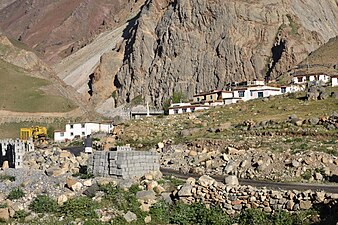
Mud (also known as Mudh) is a small village in the cold desert region of Spiti in Himachal Pradesh, India. Located at an altitude of 3,810 m (12,500 ft) on the left bank of the Pin River, a right bank tributary of the Spiti River, the village nestles at the base of the Parbati range that towers almost vertically 1,600 m (5,200 ft) above. Mud is near the boundary of the Pin Valley National Park and is a convenient base for treks in the park, and to the neighbouring districts of Kullu and Kinnaur. It is the last village on the Spiti side of the Pin Parbati trek to Kullu and the Pin Bhaba trek to Kinnaur.
Description[]

Mud is located on the left bank of the Pin River, which is a right bank tributary of the Spiti River. The village nestles at the base of the towering Pin Parbati range that separates Spiti from Kullu district. It is the first inhabited place encountered by travelers coming from Kullu valley via the Pin Parbati Pass and from Kinnaur via the Pin Bhaba Pass.[1][2] The village is at a distance of 48 kilometres (30 mi) from Kaza, Spiti. This is the route on NH-505 from Manali.[3] From Tabo, en route on NH-505 from Shimla, the distance is 65 km (40 mi).[4] The village covers an area of 77.6 hectares (192 acres).[5]: 252
Demographics and amenities[]

The population as of the 2011 Census was 213 (females: 113 (53%), males: 100 (47%)), with 45 households.[5][6]: 98 The literacy rate among females is 54% and among males is 81%. The majority of the population are Scheduled Tribes comprising 96.2%, while Scheduled Castes comprise 1.88%.[6]: 99 The language spoken in Spiti is Bhoti.[5]: 62
Mud is a village in the Sagnam Gram Panchayat.[7] A government primary and middle school caters to children of the village.[5]: 252 The village has a branch post office. The nearest full-service sub post office including international speed post is located at Sagnam, a distance of 14 km (8.7 mi).[8][9]
Places of interest[]

Mud is a convenient base for visiting the Pin Valley National Park. Trails from Mud head north and west to the National Park, west to Kullu district via the Pin Parbati Pass, and south to Kinnaur district via the Pin Bhaba Pass.
The Pin Valley is a cold desert with alpine pasture or dry alpine scrub forest. Located at a high altitude with the upper reaches being largely unexplored, the area is home to several endangered species including the snow leopard. About 20 species of birds and animals are found in the National Park, some of which may be seen in the Pin valley near Mud. These include Ibex, Chhumurthi horse, Bharal, Red fox, Marten, Weasel, Pika, Snow Cock, Bearded vulture, Chukor, Golden Eagle, Griffon, Yellow-billed Chough, Raven etc.[10]
Mud has two Buddhist nunneries, meditation caves and shelters. These belong to the Nyingmapa school, the oldest of the four major schools of Tibetan Buddhism.[11] These are located on the Killung Nala, a small stream that meets the Pin River at Mud.[2]
Mud is the last village on the trekking trails to the Kullu valley and to Kinnaur district. Both routes start along the left bank of the Pin River. After about 12 km (7.5 mi) the trail reaches Chhochhden Camp at the confluence of 3 nallahs. The ruins of Lyungti Khar, a fort built by the Kullu Rajas, is nearby. One trail heads west towards the Pin Parbati Pass (elev. 5,319 m (17,451 ft) and down the Parbati valley to Manikaran and Kullu. This trek usually takes 5-7 days.[2]
The other trail continues south from Chhochhden Camp to the Pin Bhaba Pass (elev. 4,890 m (16,040 ft) and on to Kaphnu in Kinnaur, a total distance of 50 km (31 mi). Kaphnu is 18 km (11 mi) from NH 5 which runs along the Satluj River to Shimla. This trek takes 4-5 days for the 50 km (31 mi) distance. Harish Kapadia reported that local people traveling to Shimla for business or studies would prefer the short trek over the Pir Bhaba Pass to the uncertain 254 km (158 mi) road journey via Tabo.[2][12]
Transport[]
During the summer, public buses and private vans ply regularly from Kaza to Mikkim and Mud villages in the Pin valley. During the winter, buses do not ply to the Pin valley. Then, the approach to Mud is via private vehicle and foot from Attargo bridge off NH-505, a distance of 33 km (21 mi).[10][13]
Accommodation[]
There are a few home stays in Mud, the oldest being Tara House Home Stay.[14]
Gallery[]
Road from Kaza entering Mud

Nyingma monastery, Mud

Mud nestling at the base of the towering 1,600 m (5,200 ft) Parbati range

 View down the Pin valley to Mud

Right bank of Pin river looking towards Mud, Jun '18

Hikers approach Mud on left bank of Pin
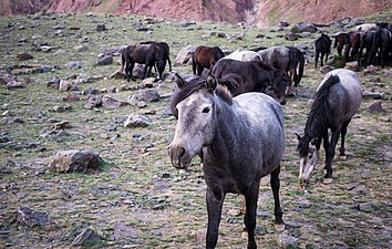
Chhumurthi horses near Mud

Sparse alpine vegetation, Jun '18
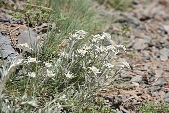
Sparse Alpine vegetation, Jun '18

Brandt's Mountain finch, Jun '18

Field of peas in Mud village, Jun '18
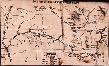
Trail from Mud to Kullu via the Pin Parbati Pass


See also[]
- Pin Valley National Park
- Pin Parbati Pass
- Pin Bhaba Pass
- Spiti Valley
References[]
| Wikimedia Commons has media related to Mudh (Mud), Spiti. |
- ^ "Pin Parbati trekking route". OpenStreetMap. Retrieved 5 July 2021.
{{cite web}}: CS1 maint: url-status (link) - ^ a b c d Kapadia, Harish (2001). Trekking and Climbing in the Indian Himalaya. Mechanicsburg, Pennsylvania: Stackpole Books. pp. 127–134. ISBN 0811729532.
- ^ "Kaza-Mud route". OpenStreetMap. Retrieved 4 July 2021.
{{cite web}}: CS1 maint: url-status (link) - ^ "Tabo-Mud route". OpenStreetMap. Retrieved 4 July 2021.
{{cite web}}: CS1 maint: url-status (link) - ^ a b c d District Census Handbook: Lahul & Spiti, Himachal -- Village and Town Directory. 3 Part XII A. Directorate of Census Operations, Himachal Pradesh, Ministry of Home Affairs, Govt of India. 2011.
- ^ a b District Census Handbook: Lahul & Spiti, Himachal -- Village and Town Wise Primary Census Abstract (PCA). 3 Part XII B. Directorate of Census Operations, Himachal Pradesh, Ministry of Home Affairs, Govt of India. 2011.
- ^ "List of PRIs" (PDF). Panchayati Raj Department, HP Govt. Retrieved 25 January 2021.
{{cite web}}: CS1 maint: url-status (link) - ^ Himachal Pradesh, Lahul and Spiti. "Locate Post Office". India Post. Retrieved 4 July 2021.
{{cite web}}: CS1 maint: url-status (link) - ^ "Sagnam-Mud Route". OpenStreetMap. Retrieved 4 July 2021.
{{cite web}}: CS1 maint: url-status (link) - ^ a b District Lahaul and Spiti, Tourism. "Pin Valley National Park". Lahaul and Spiti district. Retrieved 4 July 2021.
{{cite web}}: CS1 maint: url-status (link) - ^ Mitra, Swati, ed. (2006). The Buddhist Trail in Himachal: A Travel Guide. Good Earth Publications. ISBN 9788187780335.
- ^ "Mud, Spiti - Wangtu, Kinnaur route". OpenStreetMap. Retrieved 6 July 2021.
{{cite web}}: CS1 maint: url-status (link) - ^ "NH-505 Attargo bridge-Mud Route". OpenStreetMap. Retrieved 4 July 2021.
{{cite web}}: CS1 maint: url-status (link) - ^ "Tara House Home Stay". Tripadvisor.in. Retrieved 4 July 2021.
{{cite web}}: CS1 maint: url-status (link)
- Villages in Lahaul and Spiti district