Mueang Ranong district
This article does not cite any sources. (July 2018) |
Mueang Ranong
เมืองระนอง | |
|---|---|
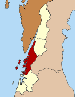 District location in Ranong province | |
| Coordinates: 9°58′2″N 98°38′2″E / 9.96722°N 98.63389°ECoordinates: 9°58′2″N 98°38′2″E / 9.96722°N 98.63389°E | |
| Country | Thailand |
| Province | Ranong |
| Seat | Khao Niwet |
| Area | |
| • Total | 713.7 km2 (275.6 sq mi) |
| Population (2005) | |
| • Total | 90,569 |
| • Density | 126.9/km2 (329/sq mi) |
| Time zone | UTC+7 (ICT) |
| Postal code | 85000 |
| Geocode | 8501 |

Mueang Ranong (Thai: เมืองระนอง) is the capital district (amphoe mueang) of Ranong province, southern Thailand.
Geography[]
Neighboring districts are (from the north clockwise) La-un of Ranong Province, Phato of Chumphon province, and Kapoe of Ranong. To the west across the Kraburi River estuary is the Tanintharyi Division of Myanmar.
Administration[]
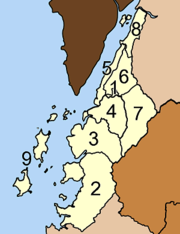
The district is divided into nine sub-districts (tambons), which are further subdivided into 39 villages (muban). The town (thesaban mueang) Ranong covers tambon Khao Niwet. There are three sub-district municipalities (thesaban tambon): Ngao and Pak Nam each cover parts of the same-named tambons, while Bang Rin covers the whole tambon. There are a further seven tambon administrative organization (TAO).
|
|
External links[]
- amphoe.com (Thai)
| Wikimedia Commons has media related to Mueang Ranong District. |
This Ranong Province location article is a stub. You can help Wikipedia by . |
- Ranong
- Districts of Ranong province
- Southern Thailand geography stubs