Mugling
Mugling
मुग्लिङ | |
|---|---|
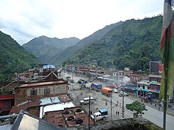 Mugling in 2010 | |
 Mugling | |
| Coordinates: 27°51′26″N 84°33′38″E / 27.85712630356841°N 84.56045946773389°ECoordinates: 27°51′26″N 84°33′38″E / ��27.85712630356841°N 84.56045946773389°E | |
| Country | |
| Province | Bagmati Province |
| District | Chitwan District |
| Government | |
| • Type | Town council |
| • Body | Ichchhakamana Rural Municipality |
| Time zone | UTC+5:45 (Nepal Time) |


Mugling (Nepali: मुग्लिङ; sometimes known as Muglin) is a town in Chitwan, Bagmati Province, Nepal.
Mugling is located at an interchange of two majors highways: Prithvi and Madan Ashrit Highway (also known as Mugling-Narayanghat Highway).[1][2] Before the 1970s, Mugling was a fishing village at the confluence of Marshyangdi River and Trishuli River.[1][3] Soon after the two highways were connected, the town saw a major transformation and became synonymised as a "town that never slept".[1][4]
In 2005, it was reported that Mugling became like a ghost town due to the Nepalese Civil War, rising violence, and crime.[1] During the war, the Nepal government had installed an army checkpoint at the market.[5]
References[]
- ^ a b c d "Gloom and doom on the highways". Nepali Times. Retrieved 7 September 2021.
{{cite web}}: CS1 maint: url-status (link) - ^ Mahler, Ferd (1999). Under the Painted Eyes: A Story of Nepal. Motilal Banarsidass Publishe. p. 324. ISBN 978-81-208-1683-1.
- ^ "A guide to eating in Mugling". The Kathmandu Post. Retrieved 7 September 2021.
{{cite web}}: CS1 maint: url-status (link) - ^ Nepal. Lonely Planet Publications. 1999. ISBN 978-0-86442-704-5.
- ^ Polak, Paul (19 March 2009). Out of Poverty: What Works When Traditional Approaches Fail: Easyread Super Large 20pt Edition. ReadHowYouWant.com. pp. 270–272. ISBN 978-1-4429-7054-0.
This article about a location in the Chitwan District of Nepal is a stub. You can help Wikipedia by . |
- Populated places in Chitwan District
- Towns in Nepal
- Bagmati Province geography stubs