Mulanje
Mulanje | |
|---|---|
 | |
 Mulanje Location in Malawi | |
| Coordinates: 16°01′33″S 35°30′29″E / 16.02583°S 35.50806°ECoordinates: 16°01′33″S 35°30′29″E / 16.02583°S 35.50806°E | |
| Country | |
| Region | Southern Region |
| District | Mulanje District |
| Population (2018 Census[1]) | |
| • Total | 14,782 |
| Time zone | +2 |
| Climate | Cwa |

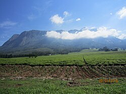
Mulanje, formerly called Mlanje, is a town in the Southern Region of Malawi, close to the border with Mozambique, to the east. It is near the Mulanje Massif.[2]
Location[]
The town of Mulanje lies along the M-2 highway from Thyolo to the west to the Mozambican border to the east. It is approximately 69 kilometres (43 mi), by road, south-east of Blantyre, the commercial and financial capital of Malawi.[3] This is approximately 380 kilometres (236 mi), by road, southeast of Lilongwe, the largest city in Malawi and the country's capital.[4] The geographical coordinates of the town of Mulanje are: 16°01'33.0"S, 35°30'29.0"E (Latitude:-16.025833; Longitude:35.508056).[5]
Overview[]
Mulanje is a tourist attraction and serves as a staging base for climbers who want to scale Mount Mulanje or those who want to explore the countryside at its base. Residential and camping accommodation is available.[6]
Mulanje is also the headquarters of the conservation group, the Mulanje Mountain Conservation Trust.[2] The small town of Mulanje is the center of Malawi's tea growing industry.[7] The Lujeri Tea Estate, adjacent to the border with Mozambique, is the location of the 8.25 megawatts (11,063 hp) Ruo–Ndiza Hydroelectric Power Station, that is owned and operated by Mulanje Renewable Energy Plc, a private enterprise.[8]
Demographics[]
| Year | Population |
|---|---|
| 1987 | 7,113 |
| 1998 | 12,548 |
| 2008 | 14,497 |
| 2018 | 14,782[1] |
Points of interest[]
The following points of interest in or near the town of Mulanje include the following: (a) the offices of Mulanje Town Council (b) the offices of Mulanje District Administration (c) Mulanje District Hospital[5] (d) a branch of National Bank of Malawi[9] (e) a branch of NBS Bank[10] and (f) the headquarters of Malawi-Mulanje Mountain Biodiversity Conservation Project.[11]
See also[]
References[]
- ^ a b "2018 Population and Housing Census Main Report" (PDF). Malawi National Statistical Office. Retrieved 25 December 2019.
- ^ a b Henry Wismayer (12 December 2013). "A trek across Malawi's Mount Mulanje, long rumored to have inspired J.R.R. Tolkien". The Washington Post. Washington, DC. Retrieved 9 May 2020.
- ^ Google (9 May 2020). "Road Distance Between Blantyre And Mulanje" (Map). Google Maps. Google. Retrieved 9 May 2020.
- ^ Google (9 May 2020). "Road Distance Between Lilongwe And Mulanje" (Map). Google Maps. Google. Retrieved 9 May 2020.
- ^ a b Google (9 May 2020). "Location of Mulanje Town, Mulanje District, Southern Region, Malawi" (Map). Google Maps. Google. Retrieved 9 May 2020.
- ^ Journeys By Design (2020). "Bespoke Safaris In Mulanje, Malawi". Brighton, United Kingdom: Journeysbydesign.com. Retrieved 9 May 2020.
- ^ Jane Pettigrew (1 February 2016). "Advances in Smallholder Tea Farming in Malawi". Stir-Tea-Coffee.com. Retrieved 9 May 2020.
- ^ Elijah Phimbi (26 February 2019). "$16 Million Power Project On Course In Mulanje: To Supply Electricity To Escom From March". Nyasa Times. Blantyre. Retrieved 9 May 2020.
- ^ Brabys (21 May 2018). "National Bank of Malawi: Mulanje Branch". Brabys.com. Retrieved 21 May 2018.
- ^ AfricanAdvice.Com (21 May 2018). "NBS Bank (Mulanje Branch)". AfricanAdvice.Com. Retrieved 21 May 2018.
- ^ Nathalie Weier Johnson (27 March 2001). "About Malawi-Mulanje Mt. Biodiversity Conservation Project" (PDF). Washington, DC: World Bank. Retrieved 21 May 2018.
- Malawi–Mozambique border crossings
- Populated places in Southern Region, Malawi
- Mulanje District