Mulroy Island
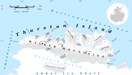 Map of Thurston Island | |
 Mulroy Island Location in Antarctica | |
| Geography | |
|---|---|
| Location | Antarctica |
| Coordinates | 71°51′S 98°0′W / 71.850°S 98.000°WCoordinates: 71°51′S 98°0′W / 71.850°S 98.000°W |
| Administration | |
| Administered under the Antarctic Treaty System | |
| Demographics | |
| Population | Uninhabited |


Satellite image of Thurston Island.
Mulroy Island is a small island which lies just off Black Crag, the northeast extremity of Noville Peninsula, Thurston Island. Discovered by the in February 1960. Named by Advisory Committee on Antarctic Names (US-ACAN) for , fuel engineer with Byrd Antarctic Expedition in 1928–30.
Maps[]
- Thurston Island – Jones Mountains. 1:500000 Antarctica Sketch Map. US Geological Survey, 1967.
- Antarctic Digital Database (ADD). Scale 1:250000 topographic map of Antarctica. Scientific Committee on Antarctic Research (SCAR). Since 1993, regularly upgraded and updated.
See also[]
- List of Antarctic and sub-Antarctic islands
![]() This article incorporates public domain material from the United States Geological Survey document: "Mulroy Island". (content from the Geographic Names Information System)
This article incorporates public domain material from the United States Geological Survey document: "Mulroy Island". (content from the Geographic Names Information System)
| General |
|  |
|---|---|---|
| Regions | ||
| Waterways | ||
| Famous explorers | ||
This Thurston Island location article is a stub. You can help Wikipedia by . |
Categories:
- Islands of Ellsworth Land
- Thurston Island geography stubs