Muna Island
Native name: Wuna (Witeno Wuna) | |
|---|---|
 Muna | |
| Geography | |
| Location | South East Asia |
| Coordinates | 5°00′S 122°30′E / 5.0°S 122.5°ECoordinates: 5°00′S 122°30′E / 5.0°S 122.5°E |
| Area | 3,341.5 km2 (1,290.2 sq mi) |
| Highest elevation | 250 m (820 ft) |
| Highest point | Unnamed |
| Administration | |
| Province | |
| Largest settlement | Raha |
| Demographics | |
| Population | 314,750 (2010) |
| Pop. density | 94.1/km2 (243.7/sq mi) |
| Ethnic groups | Muna people, Butonese people, Bugis, Javanese |

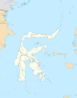
Muna within the Buton Archipelago
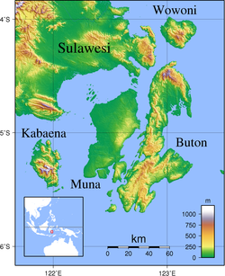
Muna (Pulau Muna) is an island in the Southeast Sulawesi province of Indonesia with an area of 3,341.5 km2 (1,290.2 sq mi), and a population of 314,750 at the 2010 Census.[1] It is located just southeast of the island of Sulawesi. It currently comprises most of three regencies within the province - Muna Regency (Kabupaten Muna), West Muna Regency (Kabupaten Muna Barat) and Central Buton Regency (Kabupaten Buton Tengah).
| Kabupaten | Area in km2. |
Pop'n Census 2010 |
comprising |
|---|---|---|---|
| Muna Regency (part) | 1,627.9 | 172,435 | all districts except Towea, Pasih Putih, Pasi Kolaga, Wakorumba Selatan, Batukara and Maligano |
| West Muna Regency (part) |
958.7 | 65,226 | all districts except Kepulauan Tiworo |
| Central Buton Regency (part) |
754.9 | 77,089 | all districts except Talaga Raya |

Three men from the Island of Muna, on the left stands a nobleman and in the centre and to the right is a man from the Reha people
References[]
- ^ Biro Pusat Statistik, Jakarta, 2011.
| hide Authority control | |
|---|---|
| General | |
| National libraries | |
This Southeast Sulawesi location article is a stub. You can help Wikipedia by . |
Categories:
- Islands of Sulawesi
- Landforms of Southeast Sulawesi
- Sulawesi geography stubs