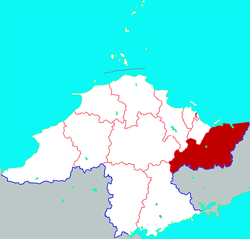
Muping District
This article needs additional citations for verification. (December 2009) |
Muping District
牟平区 Mowping | |
|---|---|
 Location in Yantai | |
 Muping Location in Shandong | |
| Coordinates: 37°23′13″N 121°36′00″E / 37.387°N 121.600°ECoordinates: 37°23′13″N 121°36′00″E / 37.387°N 121.600°E | |
| Country | People's Republic of China |
| Province | Shandong |
| Prefecture-level city | Yantai |
| Area | |
| • Total | 1,511 km2 (583 sq mi) |
| Population (2017) | |
| • Total | 451,000 |
| • Density | 300/km2 (770/sq mi) |
| Time zone | UTC+8 (China Standard) |
| Postal code | 264100 |
| Website | www |
Muping District (Chinese: 牟平区; pinyin: Mùpíng Qū), formerly also known as Ninghai[1] or Ninghaichow,[2] is a district administered by the prefecture-level city of Yantai, Shandong province, People's Republic of China,[3] and is the easternmost county-level division of Yantai.
Administrative divisions[]
As 2012, this district is divided to 3 subdistricts and 10 towns.[4]
- Subdistricts
- Ninghai Subdistrict (宁海街道)
- Wenhua Subdistrict (文化街道)
- Yangmadao Subdistrict (养马岛街道)
- Towns
|
References[]
- ^ Fuller (1943), p. 152.
- ^ "HEAVY FIGHTING AT CHEFOO". The Straits Times. 2 April 1929. Retrieved 16 October 2018.
- ^ servinghistory.com
- ^ 烟台市-行政区划网 www.xzqh.org (in Chinese). XZQH. Retrieved 2012-05-24.
Bibliography[]
- Fuller, Joseph V. (1943). Papers relating to the foreign relations of the United States, 1929, Volume II. Washington, D.C.: United States Government Publishing Office.
Categories:
- Muping District
- County-level divisions of Shandong
- Yantai
- Shandong geography stubs
