Mvoti to Umzimkulu Water Management Area
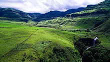
Sterkspruit Falls with the foothills of the Drakensberg in the background.
Mvoti to Umzimkulu WMA, or Mvoti to Umzimkulu Water Management Area (coded: 11), Includes the following major rivers: the Mvoti River, , Mdloti River, Ohlanga River, Mngeni River, , , Mkomazi River, , Mzimkulu River and Mtamvuna River[1] and covers the following Dams:
- Albert Falls Dam Mgeni River
- Hazelmere Dam Mdloti River
- Inanda Dam Mgeni River
- Midmar Dam Mgeni River
- Nagle Dam Mgeni River
Boundaries[]
Primary drainage region U and tertiary drainage regions T40, T51 and T52.
References[]
Categories:
- Water Management Areas
- Dams in South Africa