Myrofyllo
Myrofyllo
Μυρόφυλλο | |
|---|---|
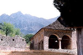 Old monastery in Myrofyllo | |
 Myrofyllo Location within the regional unit  | |
| Coordinates: 39°22′N 21°19′E / 39.367°N 21.317°ECoordinates: 39°22′N 21°19′E / 39.367°N 21.317°E | |
| Country | Greece |
| Administrative region | Thessaly |
| Regional unit | Trikala |
| Municipality | Pyli |
| • Municipal unit | 32.9 km2 (12.7 sq mi) |
| Elevation | 773 m (2,536 ft) |
| Population (2011)[1] | |
| • Municipal unit | 448 |
| • Municipal unit density | 14/km2 (35/sq mi) |
| Time zone | UTC+2 (EET) |
| • Summer (DST) | UTC+3 (EEST) |
| Vehicle registration | ΤΚ |

Myrofyllo (Greek: Μυρόφυλλο) is a village and a former community in the Trikala regional unit, Thessaly, Greece. Since the 2011 local government reform it is part of the municipality Pyli, of which it is a municipal unit.[2] The municipal unit has an area of 32.932 km2.[3] Its population is 350 in the winter and 1000 in the summer.[4]
References[]
- ^ a b "Απογραφή Πληθυσμού - Κατοικιών 2011. ΜΟΝΙΜΟΣ Πληθυσμός" (in Greek). Hellenic Statistical Authority.
- ^ "ΦΕΚ B 1292/2010, Kallikratis reform municipalities" (in Greek). Government Gazette.
- ^ "Population & housing census 2001 (incl. area and average elevation)" (PDF) (in Greek). National Statistical Service of Greece. Archived from the original (PDF) on 2015-09-21.
- ^ "Myrofyllo ( Myrokovo )". Municipality of Koziakas. Retrieved 2008-12-27.[dead link]
This Thessaly location article is a stub. You can help Wikipedia by . |
Categories:
- Populated places in Trikala (regional unit)
- Thessaly geography stubs