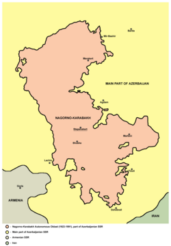
Nagorno-Karabakh Autonomous Oblast
| Nagorno-Karabakh Autonomous Oblast | |||||||||||
|---|---|---|---|---|---|---|---|---|---|---|---|
| Autonomous oblast of Azerbaijan Soviet Socialist Republic | |||||||||||
| 1923–1991 | |||||||||||
 Flag
 Coat of arms
| |||||||||||
 | |||||||||||
| Capital | Stepanakert | ||||||||||
| Area | |||||||||||
• 1989 | 4,388 km2 (1,694 sq mi) | ||||||||||
| Population | |||||||||||
• 1989 | 189,085 | ||||||||||
| • Type | Autonomous Oblast | ||||||||||
| History | |||||||||||
• Established | July 7 1923 | ||||||||||
• Abolished | November 26 1991 | ||||||||||
| |||||||||||
| Population source:[1] | |||||||||||
The Nagorno-Karabakh Autonomous Oblast[a] (NKAO) was an autonomous oblast within the Azerbaijan Soviet Socialist Republic, mostly inhabited by ethnic Armenians.[2][3][4]
History[]
The area was disputed between Armenia and Azerbaijan during their short-lived independence from 1918 and 1920. After the Sovietization of Armenia and Azerbaijan, Kavbiuro decided to keep Karabakh within Azerbaijan SSR with broad regional autonomy, with the administrative center in the city of Shusha.[5][6]
On July 7, 1923, Nagorno-Karabakh Autonomous Oblast was created and the capital was moved to Stepanakert (formerly known as Khankendi).[7] At the time of its formation, its area was 4,161 km2 (1,607 sq mi).[7] According to the 1926 census, the population of the region was 125,200 people, among whom the Armenians accounted for 89.2%. However, by 1989, the share of Armenians dropped to 76.9% of the population of the autonomous region.[8] Reasons for this include the policy of Soviet Azerbaijani authorities to settle Azerbaijanis in the region and some out-migration of Karabakh Armenians, as well as the generally higher birthrate among Azerbaijanis than among Armenians.[9]
Although the question of Nagorno-Karabakh's status did not become a major public issue until the mid-1980's, Armenian intellectuals, Soviet Armenian and Karabakh Armenian leadership periodically made appeals to Moscow for the region's transfer to Soviet Armenia.[9] In 1945, the leader of Soviet Armenia Grigory Arutinov appealed to Stalin to attach the region to Soviet Armenia, which was rejected.[9] In 1965, thirteen Karabakh Armenian party officials wrote to Soviet leadership with their grievances about the attitude of Soviet Azerbaijani officials towards the NKAO. Many of these Karabakh Armenian officials were dismissed or moved to Armenia.[9] The rise of Heydar Aliyev to leadership of the Azerbaijani SSR in 1969 saw increasing attempts to tighten Baku's control over the autonomous region. In 1973-74 Aliyev purged the entire leadership of the NKAO, who were regarded as Armenian nationalists, and appointed Boris Kevorkov, an Armenian from outside Karabakh, as the local party boss.[9]
In 1977, the prominent Armenian author Sero Khanzadyan wrote an open letter to Leonid Brezhnev calling for Nagorno-Karabakh's annexation to Soviet Armenia.[10]
Military conflict[]

The conflict between the Armenians in the oblast and the government of the Azerbaijan SSR broke out in 1987. The fighting escalated into the First Nagorno-Karabakh War by the end of 1991. On November 26, 1991, the parliament of the Azerbaijan SSR abolished the autonomous status of the oblast. Its internal administrative divisions were also abolished, and its territory was split up and redistributed amongst the neighboring administrative raions of Khojavend, Tartar, Goranboy, Shusha, and Kalbajar.[11] In response, the majority Armenian population of the oblast declared their independence as the Nagorno-Karabakh Republic which was supported by Armenia.[12][13] Today, most of the territory of the former oblast is under the control of the self-proclaimed Republic of Artsakh. Azerbaijan regained control of the southern part of the former autonomous oblast during the 2020 Nagorno-Karabakh war.[14]
Current status[]
As of 2021, the central and northern part of the former NKAO is under de facto control of the self-proclaimed Republic of Artsakh. However, the republic is not recognized by any country and the area of the former oblast is internationally regarded as part of Azerbaijan.[15] Azerbaijan dissolved the oblast as an entity of Azerbaijan on November 26, 1991 by the Law on Abolishment of Nagorno-Karabakh Autonomous Oblast. Since then the territory of the autonomous oblast has been administratively split between the Azerbaijani rayons Khojavend, Shusha, Khojaly, the east portion of Kalbajar and the west portion of Tartar.
Administrative divisions[]
It was divided into five raions or administrative divisions:
- Mardakert District (NKAO)
- Martuni District (NKAO)
- Shusha District (NKAO)
- Askeran District (NKAO)
- Hadrut District (NKAO)
Demography[]
Dynamics of number and ethnic composition of the population of Nagorno-Karabakh according to the All-Union census 1926 – 1989 years
| Nationalities | 1926[16] census |
% | 1939[17] census |
% | 1959[18] census |
% | 1970[19] census |
% | 1979[20] census |
% | 1989[21] census |
% |
|---|---|---|---|---|---|---|---|---|---|---|---|---|
| Overall | 125159 | 100,00% | 150837 | 100,00% | 130406 | 100,00% | 150313 | 100,00% | 162181 | 100,00% | 189085 | 100,00% |
| Armenians | 111694 | 89,24% | 132800 | 88,04% | 110053 | 84,39% | 121068 | 80,54% | 123076 | 75,89% | 145450 | 76,92% |
| Azerbaijanis[22] | 12592 | 10,06% | 14053 | 9,32% | 17995 | 13,80% | 27179 | 18,08% | 37264 | 22,98% | 40688 | 21,52% |
| Russians | 596 | 0,48% | 3174 | 2,10% | 1790 | 1,37% | 1310 | 0,87% | 1265 | 0,78% | 1922 | 1,02% |
| Ukrainians | 35 | 0,03% | 436 | 0,29% | 238 | 0,18% | 193 | 0,13% | 140 | 0,09% | 416 | 0,22% |
| Belarussian | 12 | 0,01% | 11 | 0,01% | 32 | 0,02% | 35 | 0,02% | 37 | 0,02% | 79 | 0,04% |
| Greeks | 68 | 0,05% | 74 | 0,05% | 67 | 0,05% | 33 | 0,02% | 56 | 0,03% | 72 | 0,04% |
| Tatars | 6 | 0,00% | 29 | 0,02% | 36 | 0,03% | 25 | 0,02% | 41 | 0,03% | 64 | 0,03% |
| Georgians | 5 | 0,00% | 25 | 0,02% | 16 | 0,01% | 22 | 0,01% | 17 | 0,01% | 57 | 0,03% |
| Others | 151 | 0,12% | 235 | 0,16% | 179 | 0,14% | 448 | 0,30% | 285 | 0,18% | 337 | 0,18% |
See also[]
References[]
- ^ (in Russian) НАГОРНО-КАРАБАХСКАЯ АО (1989 г.)
- ^ Ardillier-Carras, Françoise (2006). Sud-Caucase : conflit du Karabagh et nettoyage ethnique [South Caucasus: Nagorny Karabagh conflict and ethnic cleansing] (in French). pp. 409–432.
- ^ "UNHCR publication for CIS Conference (Displacement in the CIS) – Conflicts in the Caucasus". United Nations High Commissioner for Refugees.
- ^ Yamskov, A. N. (1991). Ethnic Conflict in the Transcausasus: The Case of Nagorno-Karabakh. Theory and Society. 20. p. 659.
- ^ "Q&A with Arsène Saparov: No Evidence that Stalin 'Gave' Karabakh to Azerbaijan". armenian.usc.edu. December 10, 2018.
Of all the documents I have seen, there is no direct evidence of Stalin doing or saying something in those 12 days in the summer of 1921 that [resulted in this decision on Karabakh]. A lot of people just assume that since Stalin was an evil person, it would be typical of someone evil to take a decision like that.
- ^ Document about creation of Nagorno-Karabakh Autonomous Oblast (in Russian)
- ^ Jump up to: a b Атлас Союза Советских Социалистических Республик [Atlas of the Union of Soviet Socialist Republics]. Moscow: Central Executive Committee of the USSR. 1928.
The Autonomous Region of Nagorno-Karabakh, which is part of the SSR of Azerbaijan, was formed by the decree of the AzCEC 7 / VI 1923 from Armenian parts of the former Jevanshir, Shulgan, Karyaginsky, and Kubatly uyezds. The territory of the Region is 4.161 sq. km. According to the administrative division on 1 / I of 1927, it is divided into 5 sections or parishes. Its administrative and political center is mountains. Stepanakert (formerly the village of Khankendy). Another city of the Region is Shusha.
- ^ "All-Union Population Census of 1926. Ethnic composition of the population by regions of the republics of the USSR". demoscope.ru. 1926.
- ^ Jump up to: a b c d e De Waal, Thomas (2003). Black Garden: Armenia and Azerbaijan through Peace and War. New York and London: New York University Press. pp. 137–140.
- ^ Sanjian, Ara (January 6, 2021). "The Armenian Diasporan Press on Mountainous Karabagh, 1923-1985". entriessas.com. Entries of the Society for Armenian Studies. Retrieved January 21, 2021.
This ‘silence’ was only broken in the Diaspora with the publication of Yerevan-based novelist Sero Khanzadyan’s open letter to the Soviet leader Leonid Brezhnev in 1977, demanding Mountainous Karabagh’s annexation to Soviet Armenia.
- ^ Svante Cornell, Turkey and the Conflict in Nagorno Karabakh: A Delicate Balance Archived June 10, 2007, at the Wayback Machine, in Middle Eastern Studies Journal Vol 34, No. 1 (London: Frank Cass Publications, January 1998), pp. 51–72
- ^ Oskanian, Kevork (September 29, 2020). "Nagorno-Karabakh: are Armenia and Azerbaijan sliding towards all-out war?". The Conversation. Retrieved October 19, 2020.
- ^ Minasyan, Karen (October 2, 2020). "Why Nagorno-Karabakh? The history (both ancient and modern) that fuels the deadly conflict between Armenia and Azerbaijan". meduza.io. Retrieved October 19, 2020.
- ^ "Report: The Anatomy of Genocide – Karabakh's Forty-Four Day War". persecution.org. Retrieved May 24, 2021.
- ^ Department Of State. The Office of Electronic Information, Bureau of Public Affairs. "1993 UN Security Council Resolutions on Nagorno-Karabakh". 2001-2009.state.gov. Retrieved October 19, 2020.
- ^ Всесоюзная перепись населения 1926 года. Национальный состав населения по регионам республик СССР Демоскоп
- ^ Всесоюзная перепись населения 1939 года. Распределение городского и сельского населения областей союзных республик по национальности и полу Демоскоп
- ^ Всесоюзная перепись населения 1959 года. Городское и сельское население областей республик СССР (кроме РСФСР) по полу и национальности Демоскоп
- ^ Всесоюзная перепись населения 1970 года. Городское и сельское население областей республик СССР (кроме РСФСР) по полу и национальности Демоскоп
- ^ Всесоюзная перепись населения 1979 года. Городское и сельское население областей республик СССР (кроме РСФСР) по полу и национальности Демоскоп
- ^ Всесоюзная перепись населения 1989 года.Распределение городского и сельского населения областей республик СССР по полу и национальности Демоскоп
- ^ according to the 1926 census were designated as "Turkic people"
Notes[]
- ^ Russian: Нагорно-Карабахская автономная область, НКАО; Azerbaijani: Dağlıq Qarabağ Muxtar Vilayəti, DQMV; Armenian: Լեռնային Ղարաբաղի Ինքնավար Մարզ, ԼՂԻՄ
External links[]

| show Authority control |
|---|

- States and territories established in 1923
- States and territories disestablished in 1991
- History of the Republic of Artsakh
- Azerbaijan Soviet Socialist Republic
- Autonomous oblasts of the Soviet Union
- Armenians in Azerbaijan
- Nagorno-Karabakh