Naroulia
Naroulia
Нароўля | |
|---|---|
 | |
 Coat of arms | |
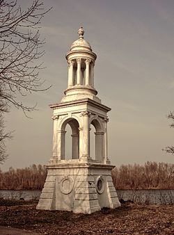
 Naroulia | |
| Coordinates: 51°53′21″N 29°57′52″E / 51.88917°N 29.96444°ECoordinates: 51°53′21″N 29°57′52″E / 51.88917°N 29.96444°E | |
| Country | |
| Voblast | Gomel Region |
| Population (2021[1]) | |
| • Total | 8 026 |
| Time zone | UTC+2 (EET) |
| • Summer (DST) | UTC+3 (EEST) |
| Postal code | 247800 |
| Area code(s) | +375 2355 |
| License plate | 3 |

Naroulia (Belarusian: Нароўля, Russian: Наровля, Polish: Narowla) is a town in the Gomel Region, Belarus. The population is 8 026 people as of 2021. In 1986, the city experienced heavy radioactive fallout from the Chernobyl accident.[2] Today it is located on the border of Polesie State Radioecological Reserve.
Gallery[]
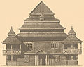
Wooden synagogue before 1906.
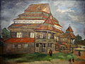
Painting of the arount 1927 by Aron Kascialianski (1891-1934)

Synagogue in 1916


References[]
- ^ Колькасць насельніцтва на 1 студзеня 2017 г. і сярэднегадавая колькасць насельніцтва за 2016 год па Рэспубліцы Беларусь у разрэзе абласцей, раёнаў, гарадоў і пасёлкаў гарадскога тыпу
- ^ "English: Chernobyl radiation map from CIA handbook, SVG'd by User:Sting, and re-anglified by me (To the same strange names used in the original)".
| Districts (raions) |
|  |
|---|---|---|
| Cities |
| |
This Belarus location article is a stub. You can help Wikipedia by . |
Categories:
- Towns in Belarus
- Populated places in Gomel Region
- Minsk Voivodeship
- Rechitsky Uyezd
- Naroulia District
- Belarus geography stubs