National Register of Historic Places listings in Anderson County, South Carolina

Location of Anderson County in South Carolina
This is a list of the National Register of Historic Places listings in Anderson County, South Carolina.
This is intended to be a complete list of the properties and districts on the National Register of Historic Places in Anderson County, South Carolina, United States. The locations of National Register properties and districts for which the latitude and longitude coordinates are included below, may be seen in a map.[1]
There are 24 properties and districts listed on the National Register in the county. Another 2 properties were once listed but have been removed.
- This National Park Service list is complete through NPS recent listings posted February 11, 2022.[2]
Current listings[]


Former listings[]
| [3] | Name on the Register | Image | Date listed | Date removed | Location | City or town | Description |
|---|---|---|---|---|---|---|---|
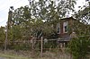
| 1 | McFall House | June 28, 1982 (#82003829) | December 8, 2005 | SR 247 34°26′40″N 82°35′40″W / 34.4444°N 82.5944°W | Anderson vicinity | No longer exists.[6] | |
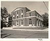
| 2 | Nick Prevost House |  |
July 10, 1984 (#84002020) | December 8, 2005 | 105 N. Prevost Street 34°30′05″N 82°40′32″W / 34.5014°N 82.6756°W | Anderson | No longer exists.[7] |
See also[]
| Wikimedia Commons has media related to National Register of Historic Places in Anderson County, South Carolina. |
- List of National Historic Landmarks in South Carolina
- National Register of Historic Places listings in South Carolina
References[]
- ^ The latitude and longitude information provided in this table was derived originally from the National Register Information System, which has been found to be fairly accurate for about 99% of listings. Some locations in this table may have been corrected to current GPS standards.
- ^ National Park Service, United States Department of the Interior, "National Register of Historic Places: Weekly List Actions", retrieved February 11, 2022.
- ^ a b Numbers represent an alphabetical ordering by significant words. Various colorings, defined here, differentiate National Historic Landmarks and historic districts from other NRHP buildings, structures, sites or objects.
- ^ "National Register Information System". National Register of Historic Places. National Park Service. March 13, 2009.
- ^ The eight-digit number below each date is the number assigned to each location in the National Register Information System database, which can be viewed by clicking the number.
- ^ South Carolina Department of Archives and History
- ^ South Carolina Department of Archives and History
| Topics |  | |
|---|---|---|
| Lists by county |
| |
| Lists by city |
| |
| Other lists | ||
Municipalities and communities of Anderson County, South Carolina, United States | ||
|---|---|---|
| Cities |  | |
| Towns | ||
| CDPs | ||
| Other communities | ||
| Footnotes | ‡This populated place also has portions in an adjacent county or counties | |
| ||
Categories:
- National Register of Historic Places in Anderson County, South Carolina
- Lists of National Register of Historic Places in South Carolina by county