[3] Name on the Register[4]
Image
Date listed[5]
Location
City or town
Description
1
Upload image September 1, 1978 (#78001928 ) Address Restricted Crumpler
2
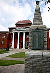
Ashe County Courthouse
May 10, 1979 (#79001658 ) 301 E. Main St. 36°25′15″N 81°28′13″W / 36.420833°N 81.470278°W / 36.420833; -81.470278 (Ashe County Courthouse ) Jefferson
3
April 28, 2015 (#15000179 ) 410 McConnell St. 36°25′02″N 81°28′46″W / 36.417222°N 81.479444°W / 36.417222; -81.479444 (Ashe County Memorial Hospital ) Jefferson
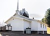
4
Baptist Chapel Church and Cemetery
November 13, 1976 (#76001302 ) E of Helton on SR 1527 36°32′51″N 81°26′42″W / 36.5475°N 81.445°W / 36.5475; -81.445 (Baptist Chapel Church and Cemetery ) Helton
5
Bower-Cox House
November 7, 1976 (#76001303 ) SW of Scottville on SR 1595 36°26′43″N 81°21′52″W / 36.445278°N 81.364444°W / 36.445278; -81.364444 (Bower-Cox House ) Scottville
6
Upload image March 21, 1978 (#78001929 ) Address Restricted Crumpler
7
Clark-Miller Roller Mill
August 19, 2014 (#14000491 ) 180 Long Branch Rd. 36°30′23″N 81°31′17″W / 36.5065°N 81.5213°W / 36.5065; -81.5213 (Clark-Miller Roller Mill ) Lansing
8
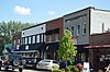
Cockerham Mill
December 10, 2014 (#14001022 ) 1580 Dog Creek Rd. Extension 36°25′04″N 81°23′03″W / 36.4179°N 81.3842°W / 36.4179; -81.3842 (Cockerham Mill )
9
A.S. Cooper Farm
September 24, 2001 (#01001028 ) Cranberry Springs Rd., approx. 0.2 miles SE of jct. with Todd RR Grade Rd. 36°16′33″N 81°32′56″W / 36.275833°N 81.548889°W / 36.275833; -81.548889 (A.S. Cooper Farm )
10
Samuel Cox House
November 7, 1976 (#76001304 ) SW of Scottville off U.S. 221 on SR 1636 36°28′28″N 81°18′51″W / 36.474444°N 81.314167°W / 36.474444; -81.314167 (Samuel Cox House ) Scottville
11
Elkland School Gymnasium
June 22, 2004 (#04000646 ) 10279 Three Top Rd., NC 1100 at jct. of NC 194 36°18′55″N 81°36′00″W / 36.315278°N 81.6°W / 36.315278; -81.6 (Elkland School Gymnasium ) Todd
12
Glendale Springs Inn
October 10, 1979 (#79003326 ) NC 16 and SR 1632 36°20′42″N 81°22′52″W / 36.345°N 81.381111°W / 36.345; -81.381111 (Glendale Springs Inn ) Glendale Springs
13
Grassy Creek Historic District Upload image December 12, 1976 (#76001300 ) SR 1535 and SR 1573 36°33′53″N 81°23′08″W / 36.564722°N 81.385556°W / 36.564722; -81.385556 (Grassy Creek Historic District ) Grassy Creek
14
R. T. Greer and Company Root and Herb Warehouse
April 18, 2003 (#03000269 ) 7181 Railroad Grade Rd., jct. of Todd Railroad Grad Rd. at Cranberry Springs Rd. 36°16′43″N 81°33′14″W / 36.278611°N 81.553889°W / 36.278611; -81.553889 (R. T. Greer and Company Root and Herb Warehouse ) Todd
15
Lansing Historic District Upload image August 18, 2011 (#11000544 ) Roughly bounded by NC 194 , G & A Sts. 36°29′59″N 81°30′39″W / 36.499722°N 81.510833°W / 36.499722; -81.510833 (Lansing Historic District ) Lansing Ashe County, North Carolina, c. 1799-1955 MPS
16
Lansing School
January 8, 2009 (#08001288 ) East side of NC 194 at junction with NC 1517 36°30��01″N 81°30′19″W / 36.500278°N 81.505278°W / 36.500278; -81.505278 (Lansing School ) Lansing
17
Miller Homestead
September 24, 2001 (#01001029 ) 324 Miller Dr. 36°29′32″N 81°33′25″W / 36.492222°N 81.556944°W / 36.492222; -81.556944 (Miller Homestead ) Lansing
18
September 11, 2018 (#100002925 ) 630 Spencer Branch Rd. 36°33′50″N 81°29′14″W / 36.5639°N 81.4873°W / 36.5639; -81.4873 (Cicero Pennington Farm )
19
Perry-Shepherd Farm Upload image April 19, 2006 (#06000289 ) 410 Swansie Shepherd Rd. 36°30′34″N 81°33′55″W / 36.509444°N 81.565278°W / 36.509444; -81.565278 (Perry-Shepherd Farm ) Lansing
20
John M. Pierce House
November 7, 1976 (#76001298 ) N of Crumpler on SR 1559 36°31′52″N 81°20′58″W / 36.531111°N 81.349444°W / 36.531111; -81.349444 (John M. Pierce House ) Crumpler
21
Upload image May 22, 1978 (#78001930 ) Address Restricted Jefferson
22
Thompson's Bromine and Arsenic Springs
October 22, 1976 (#76001299 ) W of Crumpler on SR 1542 36°30′08″N 81°23′45″W / 36.502222°N 81.395833°W / 36.502222; -81.395833 (Thompson's Bromine and Arsenic Springs ) Crumpler
23
Todd Historic District Upload image January 28, 2000 (#00000017 ) Along Todd Railroad Grade Rd., Big Hill Rd., and Carter Miller Rd. 36°18′32″N 81°35′51″W / 36.308889°N 81.5975°W / 36.308889; -81.5975 (Todd Historic District ) Todd
24
John W. Tucker House
July 29, 1985 (#85001685 ) State Route 1353 36°31′16″N 81°33′09″W / 36.521111°N 81.5525°W / 36.521111; -81.5525 (John W. Tucker House )
25
William Waddell House
November 7, 1976 (#76001301 ) West of Grassy Creek off NC 16 on State Route 1532 36°34′09″N 81°26′17″W / 36.569167°N 81.438056°W / 36.569167; -81.438056 (William Waddell House ) Grassy Creek
26
West Jefferson Historic District
October 5, 2007 (#07001076 ) Roughly bounded by State St., 3rd Ave., 2nd St.& Wilton Ave. 36°24′07″N 81°29′32″W / 36.401944°N 81.492222°W / 36.401944; -81.492222 (West Jefferson Historic District ) West Jefferson
27
Worth's Chapel
September 28, 2005 (#05001097 ) 175 Three Top Rd. 36°27′54″N 81°37′16″W / 36.465°N 81.621111°W / 36.465; -81.621111 (Worth's Chapel ) Creston