National Register of Historic Places listings in Dare County, North Carolina

This list includes properties and districts listed on the National Register of Historic Places in Dare County, North Carolina. Click the "Map of all coordinates" link to the right to view a Google map of all properties and districts with latitude and longitude coordinates in the table below.[1]
Current listings[]
- This National Park Service list is complete through NPS recent listings posted February 11, 2022.[2]
| [3] | Name on the Register[4] | Image | Date listed[5] | Location | City or town | Description |
|---|---|---|---|---|---|---|
| 1 | Ellsworth and Lovie Ballance House |  |
May 25, 2001 (#01000558) |
E side M.V. Australia Ln., 0.1 miles S of Stowe Landing Rd. 35°13′21″N 75°41′13″W / 35.2225°N 75.686944°W | Hatteras | |
| 2 | Bodie Island Lifesaving/Coast Guard Station |  |
February 9, 1979 (#79000251) |
S of Nags Head on NC 12 35°50′11″N 75°33′33″W / 35.836389°N 75.559167°W | Nags Head | |
| 3 | Bodie Island Light Station |  |
July 4, 2003 (#03000607) |
Off NC 12 35°49′12″N 75°33′49″W / 35.82°N 75.563611°W | Nags Head | |
| 4 | C.S.S. CURLEW (side-wheel steamer) |  |
August 24, 2018 (#100002802) |
Address restricted[6] | Manns Harbor | |
| 5 | Caffeys Inlet Lifesaving Station | January 30, 1978 (#78001942) |
N of Duck on SR 1200 36°13′33″N 75°46′15″W / 36.225833°N 75.770833°W | Duck | ||
| 6 | Cape Hatteras Light Station | 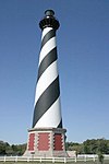 |
March 29, 1978 (#78000266) |
SE of Buxton off NC 12 in Cape Hatteras National Seashore 35°15′16″N 75°31′17″W / 35.254444°N 75.521389°W | Buxton | |
| 7 | Chicamacomico Life Saving Station |  |
December 12, 1976 (#76000164) |
NC 12 and SR 1247 35°35′42″N 75°27′54″W / 35.595°N 75.465°W | Rodanthe | |
| 8 | George Washington Creef House |  |
August 12, 1982 (#82004798) |
304 Budleigh St. 35°54′29″N 75°40′18″W / 35.908056°N 75.671667°W | Manteo | |
| 9 | John T. Daniels House |  |
May 1, 2003 (#03000339) |
960 Burnside Rd. 35°54′25″N 75°41′00″W / 35.906944°N 75.683333°W | Manteo | |
| 10 |  |
September 25, 2013 (#13000781) |
Address restricted[6] 34°55′00″N 75°02′00″W / 34.9167°N 75.0333°W | Ocracoke | ||
| 11 | E.M. CLARK (shipwreck and remains) | September 25, 2013 (#13000780) |
Address restricted[6] | Cape Hatteras | ||
| 12 | EMPIRE GEM (shipwreck and remains) | September 25, 2013 (#13000782) |
Address restricted[6] | Cape Hatteras | ||
| 13 | First Colony Inn |  |
January 21, 1993 (#92001835) |
6720 S. Virginia Dare Trail 35°55′06″N 75°36′13″W / 35.918333°N 75.603611°W | Nags Head | |
| 14 | Fort Raleigh National Historic Site |  |
October 15, 1966 (#66000102) |
4 miles N of Manteo on U.S. 158 35°56′19″N 75°42′36″W / 35.938611°N 75.71°W | Manteo | |
| 15 | Hatteras Weather Bureau Station |  |
February 17, 1978 (#78000268) |
Off NC 12 35°13′12″N 75°41′26″W / 35.22°N 75.690556°W | Hatteras | |
| 16 | Kitty Hawk Life-Saving Station |  |
October 11, 1984 (#84000073) |
U.S. 158 36°04′02″N 75°41′28″W / 36.067222°N 75.691111°W | Kitty Hawk | |
| 17 | LANCING (shipwreck) |  |
June 26, 2013 (#13000451) |
Address restricted[6] | Buxton | |
| 18 | LIGHT VESSEL 71 (shipwreck) | 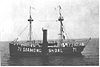 |
August 19, 2015 (#15000541) |
Address restricted[6] | Buxton | |
| 19 | Markham-Albertson-Stinson Cottage |  |
January 13, 2006 (#05001544) |
4300 W. Soundside Rd. 35°56′46″N 75°37′46″W / 35.945975°N 75.629425°W | Nags Head | Destroyed by Hurricane Irene[7] |
| 20 | Theodore S. Meekins House |  |
December 17, 1982 (#82001295) |
319 Sir Walter Raleigh St. 35°54′31″N 75°40′22″W / 35.908611°N 75.672778°W | Manteo | |
| 21 | Mattie Midgett Store and House |  |
December 23, 2004 (#04001389) |
4008 S. Virginia Dare Trail 35°57′23″N 75°37′28″W / 35.956389°N 75.624444°W | Nags Head | |
| 22 | Rasmus Midgett House | 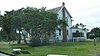 |
October 21, 2009 (#09000847) |
25438 NC Hwy 12 35°32′42″N 75°28′16″W / 35.545108°N 75.471094°W | Waves | |
| 23 | Nags Head Beach Cottages Historic District |  |
August 19, 1977 (#77000997) |
U.S. 158 35°57′50″N 75°35′49″W / 35.963889°N 75.596944°W | Nags Head | |
| 24 | Oregon Inlet Station |  |
December 23, 1975 (#75001253) |
12 miles N of Rodanthe on Pea Island 35°46′06″N 75°31′28″W / 35.768333°N 75.524444°W | Rodanthe | |
| 25 | Salvo Post Office |  |
September 23, 1993 (#93000997) |
NC 12 W side, 0.1 miles S of jct. with Park Rd. 35°32′24″N 75°28′27″W / 35.54°N 75.474167°W | Salvo | |
| 26 | Sam's Diner |  |
January 27, 1999 (#99000062) |
2008 S. Virginia Dare Trail 35°59′46″N 75°38′50″W / 35.996111°N 75.647222°W | Kill Devil Hills | |
| 27 | Sea Foam Motel |  |
December 23, 2004 (#04001392) |
7111 S. Virginia Dare Trail 35°54′37″N 75°35′47″W / 35.910278°N 75.596389°W | Nags Head | |
| 28 | U-85 (submarine) shipwreck and remains |  |
November 12, 2015 (#15000805) |
Offshore 35°54′48″N 75°17′13″W / 35.913414°N 75.286946°W | Nags Head | |
| 29 | U-576 and BLUEFIELDS (shipwrecks and remains) |  |
December 8, 2015 (#15000864) |
Address restricted[6] | Hatteras | |
| 30 | U-701 (submarine) shipwreck and remains |  |
November 12, 2015 (#15000806) |
Offshore 35°14′21″N 75°06′43″W / 35.239176°N 75.111842°W | Buxton | |
| 31 | USS HURON |  |
November 15, 1991 (#91001625) |
Shipwreck off Nags Head Coordinates missing | Nags Head | |
| 32 | USS MONITOR |  |
October 11, 1974 (#74002299) |
Shipwreck off Cape Hatteras Coordinates missing | Cape Hatteras | |
| 33 | Wright Brothers National Memorial |  |
October 15, 1966 (#66000071) |
U.S. 158 36°00′58″N 75°40′12″W / 36.016111°N 75.67°W | Kill Devil Hills |

See also[]
| Wikimedia Commons has media related to National Register of Historic Places in Dare County, North Carolina. |
- National Register of Historic Places listings in North Carolina
- List of National Historic Landmarks in North Carolina
References[]
- ^ The latitude and longitude information provided in this table was derived originally from the National Register Information System, which has been found to be fairly accurate for about 99% of listings. Some locations in this table may have been corrected to current GPS standards.
- ^ National Park Service, United States Department of the Interior, "National Register of Historic Places: Weekly List Actions", retrieved February 11, 2022.
- ^ Numbers represent an alphabetical ordering by significant words. Various colorings, defined here, differentiate National Historic Landmarks and historic districts from other NRHP buildings, structures, sites or objects.
- ^ "National Register Information System". National Register of Historic Places. National Park Service. April 24, 2008.
- ^ The eight-digit number below each date is the number assigned to each location in the National Register Information System database, which can be viewed by clicking the number.
- ^ a b c d e f g Federal and state laws and practices restrict general public access to information regarding the specific location of this resource. In some cases, this is to protect archeological sites from vandalism, while in other cases it is restricted at the request of the owner. See: Knoerl, John; Miller, Diane; Shrimpton, Rebecca H. (1990), Guidelines for Restricting Information about Historic and Prehistoric Resources, National Register Bulletin, National Park Service, U.S. Department of the Interior, OCLC 20706997.
- ^ "Hurricane Irene - the Atlantic". The Atlantic.

U.S. National Register of Historic Places | |
|---|---|
| Topics |
|
| Lists by state |
|
| Lists by insular areas | |
| Lists by associated state | |
| Other areas | |
| Related | |
| |
Municipalities and communities of Dare County, North Carolina, United States | ||
|---|---|---|
County seat: Manteo | ||
| Towns |
|  |
| CDPs |
| |
| Unincorporated communities |
| |
| Ghost town |
| |
| ||
Categories:
- Dare County, North Carolina
- Lists of National Register of Historic Places in North Carolina by county
- National Register of Historic Places in Dare County, North Carolina