[3] Name on the Register[4]
Image
Date listed[5]
Location
City or town
Description
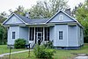
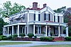
1
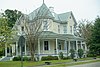
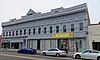
Arcade Hotel
December 19, 1986 (#86003467 ) 204 N. 5th St. 34°22′30″N 80°04′28″W / 34.375°N 80.074444°W / 34.375; -80.074444 (Arcade Hotel ) Hartsville
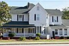
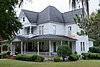
2
W.E. Cannon House and Store
May 3, 1991 (#91000470 ) 612 W. Home Ave. 34°22′19″N 80°05′18″W / 34.371944°N 80.088333°W / 34.371944; -80.088333 (W.E. Cannon House and Store ) Hartsville
3
Cashua Street-Spring Street Historic District
February 10, 1988 (#88000064 ) Cashua St. between Columbian St. and Warley St., and Spring St. between Cashua St. and N. Ervin St. 34°18′25″N 79°52′01″W / 34.306944°N 79.866944°W / 34.306944; -79.866944 (Cashua Street-Spring Street Historic District ) Darlington
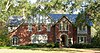
4
Coker Experimental Farms
October 15, 1966 (#66000706 ) West of Hartsville on South Carolina Highway 151 34°21′47″N 80°03′35″W / 34.363056°N 80.059722°W / 34.363056; -80.059722 (Coker Experimental Farms ) Hartsville National Historic Landmark
5
J.L. Coker Company Building
February 9, 1983 (#83002192 ) 5th St. and Carolina Ave. 34°22′27″N 80°04′22″W / 34.374167°N 80.072778°W / 34.374167; -80.072778 (J.L. Coker Company Building ) Hartsville
6
James L. Coker III House Upload image May 3, 1991 (#91000471 ) 620 W. Home Ave. 34°22′18″N 80°05′20″W / 34.371667°N 80.088889°W / 34.371667; -80.088889 (James L. Coker III House ) Hartsville
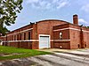
7
Robert R. Coker House
September 8, 1994 (#94001130 ) 1318 W. Carolina Ave. 34°22′01″N 80°06′22″W / 34.36686°N 80.10611°W / 34.36686; -80.10611 (Robert R. Coker House ) Hartsville
8
S. Pressly Coker House Upload image September 8, 1994 (#94001131 ) 402 W. Home Ave. 34°22′16″N 80°04′52″W / 34.371111°N 80.081111°W / 34.371111; -80.081111 (S. Pressly Coker House ) Hartsville
9
Julius A. Dargan House
February 10, 1988 (#88000036 ) 488 Pearl St. 34°18′00″N 79°52′38″W / 34.29997°N 79.87722°W / 34.29997; -79.87722 (Julius A. Dargan House ) Darlington
10
Darlington Downtown Historic District
July 5, 2006 (#06000546 ) Along portions of S. Main St., Pearl St., Public Sq., and Exchange St. 34°18′10″N 79°52′17″W / 34.302778°N 79.871389°W / 34.302778; -79.871389 (Darlington Downtown Historic District ) Darlington
11
Darlington Industrial Historic District Upload image February 10, 1988 (#88000062 ) Roughly bounded by 6th St., Ave. B, Dargan St., and Siskron St. 34°18′01″N 79°51′54″W / 34.300278°N 79.865°W / 34.300278; -79.865 (Darlington Industrial Historic District ) Darlington
12
Darlington Memorial Cemetery Upload image June 9, 2005 (#05000576 ) Ave. D and Friendship St. 34°17′34″N 79°51′22″W / 34.292778°N 79.856111°W / 34.292778; -79.856111 (Darlington Memorial Cemetery ) Darlington
13
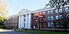
Davidson Hall, Coker College
November 10, 1983 (#83003835 ) College Ave. 34°22′38″N 80°04′05″W / 34.377222°N 80.068056°W / 34.377222; -80.068056 (Davidson Hall, Coker College ) Hartsville
14
Edmund H. Deas House
February 10, 1988 (#88000045 ) 229 Ave. E 34°17′44″N 79°51′46″W / 34.29559°N 79.86265°W / 34.29559; -79.86265 (Edmund H. Deas House ) Darlington
15
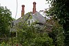
Dove Dale Upload image February 22, 2007 (#07000075 ) Address Restricted Darlington
16
C.K. Dunlap House Upload image May 3, 1991 (#91000472 ) 1346 W. Carolina Ave. 34°22′32″N 80°06′30″W / 34.375556°N 80.108333°W / 34.375556; -80.108333 (C.K. Dunlap House ) Hartsville
17
East Home Avenue Historic District
May 3, 1991 (#91000475 ) Roughly E. Home Ave. from N. 5th St. to just east of 1st Ave. 34°22′45″N 80°04′14″W / 34.379167°N 80.070556°W / 34.379167; -80.070556 (East Home Avenue Historic District ) Hartsville
18
First Baptist Church
October 17, 1991 (#88000061 ) 246 S. Main St. 34°17′59″N 79°52′12″W / 34.299722°N 79.87°W / 34.299722; -79.87 (First Baptist Church ) Darlington
19
J.B. Gilbert House
May 3, 1991 (#91000473 ) 200 Fairfield Terrace 34°22′48″N 80°04′26″W / 34.38°N 80.073889°W / 34.38; -80.073889 (J.B. Gilbert House ) Hartsville
20
Arthur Goodson House Upload image October 10, 1985 (#85003137 ) West of County Road 133 34°20′42″N 79°51′14″W / 34.345°N 79.853889°W / 34.345; -79.853889 (Arthur Goodson House ) Springville
21
John L. Hart House
November 10, 1983 (#83003843 ) Home Ave. 34°22′36″N 80°04′26″W / 34.376667°N 80.073889°W / 34.376667; -80.073889 (John L. Hart House ) Hartsville
22
John L. Hart House Upload image October 10, 1985 (#85003138 ) East of County Road 133 34°20′42″N 79°51′07″W / 34.345°N 79.851944°W / 34.345; -79.851944 (John L. Hart House ) Springville
23
Thomas E. Hart House
May 3, 1991 (#91000474 ) 624 W. Carolina Ave. 34°22′01″N 80°06′57″W / 34.366944°N 80.115833°W / 34.366944; -80.115833 (Thomas E. Hart House ) Hartsville
24
Hartsville Armory
September 8, 1994 (#94001128 ) 539 W. Carolina Ave. 34°22′09″N 80°05′06″W / 34.369167°N 80.085°W / 34.369167; -80.085 (Hartsville Armory ) Hartsville
25
Hartsville Community Center-Hartsville Community Market
June 4, 1997 (#97000538 ) 5th St. between College and Home Ave., and 106 W. College Ave. 34°22′32″N 80°04′28″W / 34.375556°N 80.074444°W / 34.375556; -80.074444 (Hartsville Community Center-Hartsville Community Market ) Hartsville
26
Hartsville Passenger Station
June 29, 1976 (#76001700 ) 114 S. 4th St. 34°22′24″N 80°04′26″W / 34.373333°N 80.073889°W / 34.373333; -80.073889 (Hartsville Passenger Station ) Hartsville
27
Hartsville Post Office
June 4, 1997 (#97000537 ) Junction of Home Ave. and 5th St. 34°22′33″N 80°04′29″W / 34.375833°N 80.074722°W / 34.375833; -80.074722 (Hartsville Post Office ) Hartsville
28
Wade Hampton Hicks House
September 8, 1994 (#94001127 ) 313 W. Home Ave. 34°22′26″N 80°04′47″W / 34.373889°N 80.079722°W / 34.373889; -80.079722 (Wade Hampton Hicks House ) Hartsville
29
Nelson Hudson House Upload image February 10, 1988 (#88000039 ) 521 Pearl St.** 34°17′56″N 79°52′40″W / 34.298889°N 79.877778°W / 34.298889; -79.877778 (Nelson Hudson House ) Darlington **house since moved from original location to unknown site
30
Japonica Hall Upload image December 21, 1989 (#89002153 ) S. Main St. 34°30′21″N 79°51′35″W / 34.505833°N 79.859722°W / 34.505833; -79.859722 (Japonica Hall ) Society Hill
31
Jacob Kelley House Upload image May 6, 1971 (#71000768 ) West of Hartsville on S-16-12 34°20′59″N 80°08′45″W / 34.349722°N 80.145833°W �� / 34.349722; -80.145833 (Jacob Kelley House ) Hartsville
32
Lawton Park and Pavilion
May 3, 1991 (#91000476 ) Prestwood Dr. at its junction with Lanier Dr. 34°22′55″N 80°04′48″W / 34.381944°N 80.08°W / 34.381944; -80.08 (Lawton Park and Pavilion ) Hartsville
33
Evan J. Lide House Upload image October 10, 1985 (#85003139 ) West of County Road 228 northwest of South Carolina Highway 34 34°19′46″N 79°50′57″W / 34.329444°N 79.849167°W / 34.329444; -79.849167 (Evan J. Lide House ) Springville
34
John W. Lide House Upload image October 10, 1985 (#85003140 ) West of County Road 133 34°21′09″N 79°51′34″W / 34.3525°N 79.859444°W / 34.3525; -79.859444 (John W. Lide House ) Springville
35
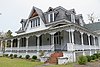
Lydia Plantation
May 28, 2010 (#10000299 ) 703 W Lydia Hwy (US HWY 15/SC HWY 34) 34°17′28″N 80°06′18″W / 34.291078°N 80.104894°W / 34.291078; -80.104894 (Lydia Plantation ) Lydia
36
Magnolia Cemetery
September 8, 1994 (#94001133 ) S. Cedar Ln. 34°21′52″N 80°05′28″W / 34.364444°N 80.091111°W / 34.364444; -80.091111 (Magnolia Cemetery ) Hartsville
37
Manne Building
February 10, 1988 (#88000044 ) 129 Pearl St. 34°18′08″N 79°52′18″W / 34.302222°N 79.871667°W / 34.302222; -79.871667 (Manne Building ) Darlington
38
Clarence McCall House
February 10, 1988 (#88000058 ) 870 Cashua St. 34°18′35″N 79°51′46″W / 34.30980°N 79.86283°W / 34.30980; -79.86283 (Clarence McCall House ) Darlington
39
Charles S. McCullough House
February 10, 1988 (#88000060 ) 480 Pearl St. 34°18′01″N 79°52′36″W / 34.3003°N 79.8767°W / 34.3003; -79.8767 (Charles S. McCullough House ) Darlington
40
A.M. McNair House
September 8, 1994 (#94001126 ) 153 W. Home Ave. 34°22′31″N 80°04′35″W / �� 34.375278°N 80.076389°W / 34.375278; -80.076389 (A.M. McNair House ) Hartsville
41
Memorial Hall
February 9, 1989 (#89000001 ) 2nd St. between Home Ave. and Carolina Ave. 34°22′42″N 80°04′01″W / 34.378333°N 80.066944°W / 34.378333; -80.066944 (Memorial Hall ) Hartsville
42
Oaklyn Plantation Upload image February 2, 1995 (#94001630 ) Junction of S. Charleston Rd. (South Carolina Highway 35 ) and Pocket Rd. (South Carolina Highway 173 ) 34°16′46″N 79°46′52″W / 34.279444°N 79.781111°W / 34.279444; -79.781111 (Oaklyn Plantation ) Darlington
43
Paul H. Rogers House
September 8, 1994 (#94001125 ) 628 W. Home Ave. 34°22′17″N 80°05′22″W / 34.371389°N 80.089444°W / 34.371389; -80.089444 (Paul H. Rogers House ) Hartsville
44
St. John's Historic District Upload image September 4, 1980 (#80003668 ) Park, St. John's, Sanders, and Orange Sts. 34°18′15″N 79°52′32″W / 34.304167°N 79.875556°W / 34.304167; -79.875556 (St. John's Historic District ) Darlington
45
South Carolina Western Railway Station
February 10, 1988 (#88000040 ) 129 Russell St. 34°18′13″N 79°52′08″W / 34.303611°N 79.868889°W / 34.303611; -79.868889 (South Carolina Western Railway Station ) Darlington
46
Welsh Neck-Long Bluff-Society Hill Historic District Upload image December 16, 1974 (#74001846 ) Southwest of Bennettsville along U.S. Route 15 34°31′35″N 79°49′39″W / 34.526389°N 79.8275°W / 34.526389; -79.8275 (Welsh Neck-Long Bluff-Society Hill Historic District ) Bennettsville
47
West Broad Street Historic District Upload image February 10, 1988 (#88000063 ) W. Broad St. between Dargan St. and Player St. 34°17′49″N 79°52′26″W / 34.296944°N 79.873889°W / 34.296944; -79.873889 (West Broad Street Historic District ) Darlington
48
West College Avenue Historic District Upload image September 8, 1994 (#94001123 ) W. College Ave. from 6th Ave. to west of 8th Ave. 34°22′24″N 80°04′43″W / 34.373333°N 80.078611°W / 34.373333; -80.078611 (West College Avenue Historic District ) Hartsville
49
White Plains Upload image October 10, 1985 (#85003141 ) North of County Road 177 and northeast of County Road 389 34°21′24″N 79°53′00″W / 34.356667°N 79.883333°W / 34.356667; -79.883333 (White Plains ) Springville
50
Wilds Hall Upload image October 10, 1985 (#85003142 ) West of County Road 228 off South Carolina Highway 34 34°19′05″N 79°50′33″W / 34.318056°N 79.8425°W / 34.318056; -79.8425 (Wilds Hall ) Springville
51
Wilds-Edwards House
February 10, 1988 (#88000034 ) 120 Edwards Ave. 34°17′54″N 79°52′33″W / 34.298333°N 79.875833°W / 34.298333; -79.875833 (Wilds-Edwards House ) Darlington
52
Mrs. B.F. Williamson House
February 10, 1988 (#88000059 ) 141 Oak St. 34°18′24″N 79°52′17″W / 34.306667°N 79.871389°W / 34.306667; -79.871389 (Mrs. B.F. Williamson House ) Darlington