[3] Name on the Register
Image
Date listed[4]
Location
City or town
Description
1
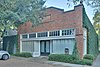
All Saints Roman Catholic Church
June 22, 1983 (#83004425 ) 201 E. 10th St. 29°47′21″N 95°23′46″W / 29.78912°N 95.39612°W / 29.78912; -95.39612 (All Saints Roman Catholic Church ) Houston
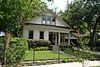
2
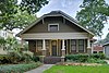
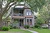
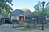
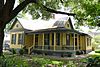
Allbach House
June 22, 1983 (#83004426 ) 2023 Arlington St. 29°48′18″N 95°23′41″W / 29.80489°N 95.39480°W / 29.80489; -95.39480 (Allbach House ) Houston
3
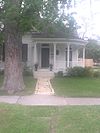
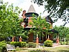
John W. Anderson House
January 15, 1988 (#87002241 ) 711 Columbia 29°47′02″N 95°23′36″W / 29.78390°N 95.39322°W / 29.78390; -95.39322 (John W. Anderson House ) Houston
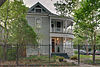
4
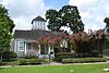
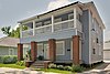
Banta House
June 22, 1983 (#83004427 ) 119 E. 20th St. 29°48′12″N 95°23′50″W / 29.803333°N 95.397222°W / 29.803333; -95.397222 (Banta House ) Houston
5
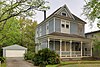
Otto H. Baring House
January 15, 1988 (#87002242 ) 1030 Rutland 29°47′23″N 95°24′02″W / 29.789722°N 95.400556°W / 29.789722; -95.400556 (Otto H. Baring House ) Houston
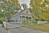
6
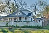
Barker House
May 14, 1984 (#84001754 ) 121 E. 16th St. 29°47′58″N 95°23′49″W / 29.799444°N 95.396944°W / 29.799444; -95.396944 (Barker House ) Houston
7
Borgstrom House
May 14, 1984 (#84001755 ) 1401 Cortlandt St. 29°47′46″N 95°23′44″W / 29.796111°N 95.395556°W / 29.796111; -95.395556 (Borgstrom House ) Houston
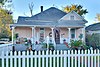
8
Burge House
June 22, 1983 (#83004430 ) 1801 Heights Blvd. 29°48′06″N 95°23′54″W / 29.801667°N 95.398333°W / 29.801667; -95.398333 (Burge House ) Houston
9
January 15, 1988 (#87002243 ) 1238 Harvard 29°47′37″N 95°23′45″W / 29.793611°N 95.395833°W / 29.793611; -95.395833 (George L. Burlingame House ) Houston
10
August 20, 2004 (#83004671 ) 219 W. Eleventh St. 29°47′27″N 95°23′59″W / 29.790969°N 95.399851°W / 29.790969; -95.399851 (Burnett House ) Houston
11
David A. Carden House
July 17, 1990 (#90001048 ) 718 W. 17th Ave. 29°48′02″N 95°24′39″W / 29.800476°N 95.410844°W / 29.800476; -95.410844 (David A. Carden House ) Houston
12
July 17, 1990 (#90001040 ) 1025 Arlington 29°47′23″N 95°23′39″W / 29.789722°N 95.394167°W / 29.789722; -95.394167 (Moses A. Clanton House ) Houston
13
Upload image January 15, 1988 (#87002244 ) 939 Arlington 29°47′18″N 95°23′40″W / 29.788462°N 95.394395°W / 29.788462; -95.394395 (J. H. Clare House ) Houston
14
Upload image January 15, 1988 (#87002248 ) 921 Arlington 29°47′15″N 95°23′39″W / 29.7875°N 95.394167°W / 29.7875; -95.394167 (Austin Copeland House I ) Houston
15
Upload image January 15, 1988 (#87002245 ) 925 Arlington 29°47′16″N 95°23′39″W / 29.787778°N 95.394167°W / 29.787778; -95.394167 (Austin Copeland House II ) Houston
16
July 17, 1990 (#90001041 ) 1037 Columbia 29°47′25″N 95°23′36″W / 29.790164°N 95.393334°W / 29.790164; -95.393334 (Charles E. Coombs House ) Houston
17
May 14, 1984 (#84001757 ) 1536 Heights Blvd. 29°47′56″N 95°23′51″W / 29.798889°N 95.3975°W / 29.798889; -95.3975 (Dr. B. F. Coop House ) Houston
18
Upload image June 22, 1983 (#83004431 ) 402 E. 9th St. 29°47′13″N 95°23′38″W / 29.786832°N 95.393914°W / 29.786832; -95.393914 (Countryman House ) Houston
19
June 22, 1983 (#83004432 ) 1418 Heights Blvd. 29°47′47″N 95°23′51″W / 29.796389°N 95.3975°W / 29.796389; -95.3975 (Cummings House ) Houston
20
Upload image May 14, 1984 (#84001761 ) 224 W. 17th St. 29°48′02″N 95°23′59″W / 29.800556°N 95.399722°W / 29.800556; -95.399722 (Dexter House ) Houston Demolished.
21
July 17, 1990 (#90001046 ) 1233 Yale St. 29°47′35″N 95°23′57″W / 29.793056°N 95.399167°W / 29.793056; -95.399167 (Lula J. Doughty House ) Houston
22
January 15, 1988 (#87002246 ) 921 Heights Blvd. 29°47′17″N 95°23′11″W / 29.788056°N 95.386389°W / 29.788056; -95.386389 (Jay L. Durham House ) Houston
23
June 22, 1983 (#83004433 ) 510 Harvard St. 29°46′47″N 95°23′45″W / 29.779722°N 95.395833°W / 29.779722; -95.395833 (Eaton House ) Houston
24
Upload image June 22, 1983 (#83004434 ) 602 E. 9th St. 29°47′13″N 95°23′30″W / 29.786871°N 95.391737°W / 29.786871; -95.391737 (Elkins House ) Houston
25
June 22, 1983 (#83004435 ) 1515 Heights Blvd. 29°47′54″N 95°23′54″W / 29.798333°N 95.398333°W / 29.798333; -95.398333 (Dr. Billie V. Ellis House ) Houston
26
May 14, 1984 (#84001762 ) 1236 Rutland St. 29°47′37″N 95°24′03″W / 29.793611°N 95.400833°W / 29.793611; -95.400833 (Ezzell House ) Houston
27
January 15, 1988 (#87002247 ) 1327 Ashland 29°47′45″N 95°24′13″W / 29.795704°N 95.403709°W / 29.795704; -95.403709 (William F. Fluegel House ) Houston Significantly altered and expanded since initial listing.
28
July 17, 1990 (#90001047 ) 221 E. 12th Ave. 29°47′34″N 95°23′45″W / 29.792766°N 95.395827°W / 29.792766; -95.395827 (Gerloff House ) Houston
29
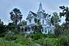
Gillette House
May 14, 1984 (#84001764 ) 301–303 E. 15th St. 29°47′52″N 95°23′43″W / 29.797778°N 95.395278°W / 29.797778; -95.395278 (Gillette House ) Houston
30
June 22, 1983 (#83004437 ) 315 W. 17th St. 29°48′04″N 95°24′08″W / 29.801129°N 95.402184°W / 29.801129; -95.402184 (Hartley House ) Houston
31
May 14, 1984 (#84001765 ) 1015 Heights Blvd. 29°47′22″N 95°23′53″W / 29.789444°N 95.398056°W / 29.789444; -95.398056 (Hawkins House ) Houston
32
May 14, 1984 (#84001766 ) Heights Boulevard from White Oak Bayou to 20th St. 29°46′10″N 95°23′50″W / 29.769444°N 95.397222°W / 29.769444; -95.397222 (Heights Boulevard Esplanade ) Houston
33
Heights Christian Church
June 22, 1983 (#83004438 ) 1703 Heights Blvd. 29°48′03″N 95°23′54″W / 29.800833°N 95.398333°W / 29.800833; -95.398333 (Heights Christian Church ) Houston
34
July 24, 2017 (#100001375 ) 339 W. 19th St. 29°48′11″N 95°24′10″W / 29.803145°N 95.402872°W / 29.803145; -95.402872 (Heights Theater ) Houston
35
May 14, 1984 (#84001771 ) 112 W. 4th St. 29°46′40″N 95°23′52″W / 29.777778°N 95.397778°W / 29.777778; -95.397778 (House at 112 W. 4th Street ) Houston
36
May 14, 1984 (#84001776 ) 122 E. 5th St. 29°46′46″N 95°23′47″W / 29.779444°N 95.396389°W / 29.779444; -95.396389 (House at 122 East Fifth Street ) Houston
37
June 22, 1983 (#83004460 ) 201 W. 15th St. 29°47′51″N 95°23′57″W / 29.7975°N 95.399167°W / 29.7975; -95.399167 (House at 201 W. 15th Street ) Houston
38
May 14, 1984 (#84001786 ) 217 E. 5th St. 29°46′46″N 95°23′44″W / 29.779444°N 95.395556°W / 29.779444; -95.395556 (House at 217 E. 5th Street ) Houston
39
June 22, 1983 (#83004447 ) 402 E. 11th Street 29°47′26″N 95°23′38″W / 29.790541°N 95.394002°W / 29.790541; -95.394002 (House at 402 E. 11th Street ) Houston
40
May 14, 1984 (#84001788 ) 444 W. 24th St. 29°48′28″N 95°24′12″W / 29.807778°N 95.403333°W / 29.807778; -95.403333 (House at 444 West 24th Street ) Houston
41
May 14, 1984 (#84001791 ) 505 W. 18th St. 29°48′07″N 95°24′22″W / 29.8020°N 95.4062°W / 29.8020; -95.4062 (House at 505 W. 18th Street ) Houston
42
Upload image June 22, 1983 (#83004448 ) 532 Harvard St. 29°46′51″N 95°23′46″W / 29.7808°N 95.3960°W / 29.7808; -95.3960 (House at 532 Harvard Street ) Houston
43
June 22, 1983 (#83004451 ) 828 Heights Blvd. 29°47′07″N 95°23′50″W / 29.7853°N 95.3972°W / 29.7853; -95.3972 (House at 828 Heights Boulevard ) Houston
44
Upload image June 22, 1983 (#83004445 ) 844 Columbia St. 29°47′13″N 95°23′34″W / 29.7869°N 95.3928°W / 29.7869; -95.3928 (House at 844 Columbia Street ) Houston
45
Upload image June 22, 1983 (#83004444 ) 844 Cortlandt 29°47′12″N 95°23′42″W / 29.7868°N 95.3950°W / 29.7868; -95.3950 (House at 844 Cortlandt ) Houston
46
May 14, 1984 (#84001793 ) 917 Heights Blvd. 29°47′14″N 95°23′53″W / 29.7872°N 95.3981°W / 29.7872; -95.3981 (House at 917 Heights Boulevard ) Houston
47
Upload image January 7, 1993 (#84003972 ) 943½ Cortlandt St. 29°47′19″N 95°23′44″W / 29.7886°N 95.3955°W / 29.7886; -95.3955 (House at 943½ Cortlandt Street ) Houston
48
Upload image December 9, 2020 (#100005898 ) 1217 Tulane St. 29°47′36″N 95°24′09″W / 29.7932°N 95.4024°W / 29.7932; -95.4024 (Houses at 1217 and 1219 Tulane Street ) Houston
49
May 14, 1984 (#84001777 ) 1227 Rutland St. 29°47′35″N 95°24′04″W / 29.7931°N 95.4011°W / 29.7931; -95.4011 (House at 1227 Rutland Street ) Houston
50
June 22, 1983 (#83004456 ) 1237 Rutland St. 29°47′37″N 95°24′04″W / 29.7936°N 95.4011°W / 29.7936; -95.4011 (House at 1237 Rutland Street ) Houston
51
May 14, 1984 (#84001768 ) 1111 Heights Blvd. 29°47′28″N 95°23′53″W / 29.7912°N 95.3981°W / 29.7912; -95.3981 (House at 1111 Heights Boulevard ) Houston
52
May 14, 1984 (#84001774 ) 1210 Harvard St. 29°47′34″N 95°23′46″W / 29.7928°N 95.3961°W / 29.7928; -95.3961 (House at 1210 Harvard Street ) Houston
53
January 15, 1988 (#87002249 ) 1217 Harvard 29°47′35″N 95°23′48″W / 29.7931°N 95.3967°W / 29.7931; -95.3967 (House at 1217 Harvard ) Houston
54
January 15, 1988 (#87002250 ) 1220 Harvard 29°47′35″N 95°23′45″W / 29.7931°N 95.3958°W / 29.7931; -95.3958 (House at 1220 Harvard ) Houston
55
July 17, 1990 (#90001043 ) 1222 Harvard St. 29°47′35″N 95°23′45″W / 29.7931°N 95.3958°W / 29.7931; -95.3958 (House at 1222 Harvard Street ) Houston
56
May 14, 1984 (#84001780 ) 1230 Oxford St. 29°47′37″N 95°23′32″W / 29.7936°N 95.3922°W / 29.7936; -95.3922 (House at 1230 Oxford Street ) Houston
57
May 14, 1984 (#84001784 ) 1304 Cortlandt St. 29°47′41″N 95°23′42″W / 29.7946°N 95.3951°W / 29.7946; -95.3951 (House at 1304 Cortlandt Street ) Houston
58
June 22, 1983 (#83004443 ) 1343 Allston St. 29°47′46″N 95°24′01″W / 29.7960°N 95.4004°W / 29.7960; -95.4004 (House at 1343 Allston Street ) Houston Significantly altered and expanded since initial listing.
59
June 22, 1983 (#83004449 ) 1421 Harvard St. 29°47′48″N 95°23′48″W / 29.7967°N 95.3967°W / 29.7967; -95.3967 (House at 1421 Harvard St. ) Houston
60
June 22, 1983 (#83004452 ) 1421 Heights Blvd. 29°47′49″N 95°23′54″W / 29.7970°N 95.3983°W / 29.7970; -95.3983 (House at 1421 Heights Boulevard ) Houston
61
January 15, 1988 (#87002251 ) 1435 Heights Blvd. 29°47′50″N 95°23′53″W / 29.7972°N 95.3981°W / 29.7972; -95.3981 (House at 1435 Heights Boulevard ) Houston
62
June 22, 1983 (#83004458 ) 1437 Waverly St. 29°47′49″N 95°24′16″W / 29.796944°N 95.404444°W / 29.796944; -95.404444 (House at 1437 Waverly Street ) Houston
63
June 22, 1983 (#83004453 ) 1437 Heights Blvd. 29°47′50″N 95°23′54″W / 29.797222°N 95.398333°W / 29.797222; -95.398333 (House at 1437 Heights Boulevard ) Houston
64
June 22, 1983 (#83004442 ) 1443 Allston St. 29°47′52″N 95°24′02″W / 29.797751°N 95.400441°W / 29.797751; -95.400441 (House at 1443 Allston Street ) Houston
65
June 22, 1983 (#83004441 ) 1509 Allston St. 29°47′55″N 95°24′02″W / 29.798486°N 95.400520°W / 29.798486; -95.400520 (House at 1509 Allston Street ) Houston
66
June 22, 1983 (#83004440 ) 1515 Allston St. 29°47′55″N 95°24′02″W / 29.798631°N 95.400468°W / 29.798631; -95.400468 (House at 1515 Allston Street ) Houston
67
Upload image June 22, 1983 (#83004446 ) 1517 Cortland St. 29°47′56″N 95°23′45″W / 29.798826°N 95.395767°W / 29.798826; -95.395767 (House at 1517 Cortland Street ) Houston
68
June 22, 1983 (#83004457 ) 1537 Tulane Street 29°47′56″N 95°24′08″W / 29.798889°N 95.402222°W / 29.798889; -95.402222 (House at 1537 Tulane Street ) Houston
69
June 22, 1983 (#83004450 ) 1640 Harvard St. 29°48′05″N 95°23′47″W / 29.801511°N 95.396361°W / 29.801511; -95.396361 (House at 1640 Harvard Street ) Houston House modified and expanded significantly since initial listing.
70
June 22, 1983 (#83004455 ) 2035 Rutland St. 29°48′17″N 95°24′06″W / 29.804722°N 95.401722°W / 29.804722; -95.401722 (House at 2035 Rutland Street ) Houston
71
June 22, 1983 (#83004459 ) 1421–1423 Waverly St. 29°47′47″N 95°24′16″W / 29.796389°N 95.404444°W / 29.796389; -95.404444 (House at 1421–1423 Waverly Street ) Houston
72
June 22, 1983 (#83004454 ) 2402 Rutland St. 29°48′29″N 95°24′05″W / 29.808161°N 95.401298°W / 29.808161; -95.401298 (House at 2402 Rutland Street ) Houston
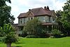
73
Houston Public Library
May 14, 1984 (#84001795 ) 1302 Heights Blvd. 29°47′39″N 95°23′51″W / 29.794167°N 95.3975°W / 29.794167; -95.3975 (Houston Public Library ) Houston
74
Houston Heights Fire Station
June 22, 1983 (#83004461 ) Yale and 12th Sts. 29°47′33″N 95°23′56″W / 29.7925°N 95.398889°W / 29.7925; -95.398889 (Houston Heights Fire Station ) Houston
75
Houston Heights Waterworks Reservoir
June 22, 1983 (#83004462 ) W. 20 and Nicolson Sts. 29°48′15″N 95°24′23″W / 29.804167°N 95.406389°W / 29.804167; -95.406389 (Houston Heights Waterworks Reservoir ) Houston
76
Houston Heights Woman's Club
June 22, 1983 (#83004463 ) 1846 Harvard St 29°48′13″N 95°23′47″W / 29.803677°N 95.396438°W / 29.803677; -95.396438 (Houston Heights Woman's Club ) Houston
77
Immanuel Lutheran Church
June 22, 1983 (#83004464 ) 1448 Cortlandt St. 29°47′52″N 95°23′42″W / 29.797778°N 95.395°W / 29.797778; -95.395 (Immanuel Lutheran Church ) Houston
78
Isbell House
June 22, 1983 (#83004465 ) 639 Heights Blvd. 29°46′56″N 95°23′52″W / 29.782222°N 95.397778°W / 29.782222; -95.397778 (Isbell House ) Houston
79
Upload image July 17, 1990 (#90001039 ) 721 Arlington 29°47′03″N 95°23′39″W / 29.784085°N 95.394260°W / 29.784085; -95.394260 (James L. Jensen House ) Houston
80
Upload image June 22, 1983 (#83004466 ) 1115–1117 Allston St. 29°47′29″N 95°24′02″W / 29.791433°N 95.400447°W / 29.791433; -95.400447 (Jones House ) Houston
81
May 14, 1984 (#84001797 ) 1448 Heights Blvd. 29°47′51″N 95°23′51″W / 29.7975°N 95.3975°W / 29.7975; -95.3975 (Keller House ) Houston
82
January 15, 1988 (#87002252 ) 1122 Harvard 29°47′28″N 95°23′45″W / 29.791111°N 95.395833°W / 29.791111; -95.395833 (Marshall W. Kennedy House ) Houston
83
Upload image June 22, 1983 (#83004467 ) 803 Yale St. 29°47′07″N 95°23′57″W / 29.785355°N 95.399132°W / 29.785355; -95.399132 (Kleinhaus House ) Houston
84
June 22, 1983 (#83004468 ) 1601 Ashland St. 29°47′59″N 95°24′10″W / 29.799722°N 95.402778°W / 29.799722; -95.402778 (Knittel House ) Houston
85
June 22, 1983 (#83004469 ) 612 W. 26th St. 29°48′34″N 95°24′18″W / 29.809444°N 95.405°W / 29.809444; -95.405 (Kronenberger House ) Houston
86
January 15, 1988 (#87002253 ) 1445 Harvard 29°47′52″N 95°23′48″W / 29.797778°N 95.396667°W / 29.797778; -95.396667 (Emil Lindenburg House ) Houston
87
July 19, 1990 (#90001045 ) 2009 Harvard 29°48′16″N 95°23′49″W / 29.804580°N 95.396945°W / 29.804580; -95.396945 (Fayette C. Lowry House ) Houston
88
June 22, 1983 (#83004470 ) 301 E. 5th St. 29°46′46″N 95°23′42″W / 29.779444°N 95.395°W / 29.779444; -95.395 (Lund House ) Houston
89
June 22, 1983 (#83004472 ) 1802 Harvard St. 29°48′06″N 95°23′47″W / 29.801667°N 95.396389°W / 29.801667; -95.396389 (Mansfield House ) Houston
90
Upload image January 15, 1988 (#87002254 ) 1026 Allston 29°47′23″N 95°23′59″W / 29.789852°N 95.399845°W / 29.789852; -95.399845 (Henry Hicks McCain House ) Houston
91
July 17, 1990 (#90001049 ) 433 W. 24th St. 29°48′29″N 95°24′16″W / 29.808056°N 95.404444°W / 29.808056; -95.404444 (D. C. McCollum House ) Houston
92
Upload image June 22, 1983 (#83004473 ) 1801 Ashland St. 29°48′06″N 95°24′10″W / 29.801667°N 95.402778°W / 29.801667; -95.402778 (McDonald House ) Houston Demolished[5]
93
Upload image May 14, 1984 (#84001813 ) 725 Harvard St. 29°47′04″N 95°23′48″W / 29.784331°N 95.396536°W / 29.784331; -95.396536 (Meitzen House ) Houston
94
May 14, 1984 (#84001814 ) 1245 Yale St. 29°47′37″N 95°23′57″W / 29.793611°N 95.399167°W / 29.793611; -95.399167 (Miller House ) Houston
95
November 12, 1980 (#80004131 ) 1102 Heights Blvd. 29°47′28″N 95°23′50″W / 29.790997°N 95.397269°W / 29.790997; -95.397269 (John Milroy House ) Houston Second duplicate listing approved in 1983 (#83004474).
96
May 14, 1984 (#84001816 ) 1602 Harvard St. 29°47′59″N 95°23′46″W / 29.799722°N 95.396111°W / 29.799722; -95.396111 (Milroy-Muller House ) Houston
97
July 17, 1990 (#90001044 ) 1611 Harvard St. 29°48′01″N 95°23′49″W / 29.800414°N 95.396824°W / 29.800414; -95.396824 (Glenn W. Morris House ) Houston
98
Morton Brothers Grocery
January 15, 1988 (#87002255 ) 401 W. Ninth 29°47′13″N 95°24′04″W / 29.786944°N 95.401111°W / 29.786944; -95.401111 (Morton Brothers Grocery ) Houston
99
May 14, 1984 (#84001819 ) 1046 Harvard St. 29°47′26″N 95°23′46″W / 29.790514°N 95.396188°W / 29.790514; -95.396188 (Mulcahy House ) Houston
100
November 12, 1991 (#87002256 ) 1148 Heights Blvd. 29°47′33″N 95°23′51″W / 29.792404°N 95.397388°W / 29.792404; -95.397388 (Forrest A. Nairn House ) Houston
101
Upload image June 22, 1983 (#83004475 ) 530 Harvard St. 29°46′50″N 95°23′46″W / 29.780639°N 95.395985°W / 29.780639; -95.395985 (Joseph Ogle House ) Houston
102
Oriental Textile Mill
June 22, 1983 (#83004476 ) 2201 Lawrence St. 29°48′22″N 95°24′30″W / 29.806083°N 95.408472°W / 29.806083; -95.408472 (Oriental Textile Mill ) Houston
103
May 14, 1984 (#84001820 ) 835 Rutland St. 29°47′09″N 95°24′03″W / 29.785833°N 95.400833°W / 29.785833; -95.400833 (Otto House ) Houston
104
June 22, 1983 (#83004477 ) 1101 Heights Blvd. 29°47′28″N 95°23′53″W / 29.791075°N 95.398054°W / 29.791075; -95.398054 (Perry-Swilley House ) Houston
105
July 17, 1990 (#90001038 ) 933 Allston St. 29°47′17″N 95°24′01″W / 29.788056°N 95.400278°W / 29.788056; -95.400278 (Thomas B. Reed House ) Houston
106
Upload image January 15, 1988 (#87002257 ) 736 Cortland 29°47′05″N 95°23′42″W / 29.784641°N 95.394922°W / 29.784641; -95.394922 (Charles Roessler House ) Houston
107
July 17, 1990 (#90001042 ) 1150 Cortlandt 29°47′33″N 95°23′42″W / 29.792419°N 95.395129°W / 29.792419; -95.395129 (Ghent W. Rogers House ) Houston
108
May 14, 1984 (#84001823 ) 1123 Harvard St. 29°47′30″N 95°23′48″W / 29.791547°N 95.396682°W / 29.791547; -95.396682 (Schlesser-Burrows House ) Houston
109
January 15, 1988 (#87002258 ) 2030 Arlington 29°48′19″N 95°23′39″W / 29.805169°N 95.394210°W / 29.805169; -95.394210 (John H. Shoaf House ) Houston
110
June 22, 1983 (#83004480 ) 1541 Tulane St. 29°47′57″N 95°24′08″W / 29.799167°N 95.402222°W / 29.799167; -95.402222 (Dr. Penn B. Thornton House ) Houston
111
June 22, 1983 (#83004482 ) 301 E. 14th St. 29°47′45″N 95°23′43″W / 29.795833°N 95.395278°W / 29.795833; -95.395278 (Upchurch House ) Houston
112
June 22, 1983 (#83004483 ) 323 W. 17th St. 29°48′01″N 95°24′04″W / 29.800278°N 95.401111°W / 29.800278; -95.401111 (Ward House ) Houston
113
Webber House
May 14, 1984 (#84001829 ) 1011 Heights Blvd. 29°47′26″N 95°23′53″W / 29.790556°N 95.398056°W / 29.790556; -95.398056 (Webber House ) Houston
114
Upload image June 22, 1983 (#83004484 ) 407 Heights Blvd. 29°46′42″N 95°23′52″W / 29.778249°N 95.397839°W / 29.778249; -95.397839 (Samuel H. Webber House ) Houston
115
May 14, 1984 (#84001831 ) 1541 Ashland St. 29°47′57″N 95°24′12″W / 29.799167°N 95.403333°W / 29.799167; -95.403333 (Wilkins House ) Houston
116
June 22, 1983 (#83004485 ) 245 W. 18th St. 29°48′08″N 95°24′04″W / 29.802129°N 95.401147°W / 29.802129; -95.401147 (Williams-Brueder House ) Houston
117
May 14, 1984 (#84001841 ) 1206 Cortlandt St. 29°47′34″N 95°23′42″W / 29.792785°N 95.395118°W / 29.792785; -95.395118 (Wilson House ) Houston
118
May 14, 1984 (#84001843 ) 703 Harvard St. 29°46′28″N 95°23′46″W / 29.774444°N 95.396111°W / 29.774444; -95.396111 (Wimberly House ) Houston
119
May 14, 1984 (#84001844 ) 1651 Columbia St. 29°47′59″N 95°23′36″W / 29.799722°N 95.393333°W / 29.799722; -95.393333 (Wisnoski House ) Houston
120
May 14, 1984 (#84001847 ) 740 Rutland St. 29°47′04″N 95°24′02″W / 29.784444°N 95.400556°W / 29.784444; -95.400556 (Woodard House ) Houston
121
June 22, 1983 (#83004486 ) 1605 Heights Blvd. 29°48′01″N 95°23′54″W / 29.800401°N 95.398304°W / 29.800401; -95.398304 (Woodward House ) Houston
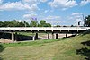
122
December 30, 2011 (#11000981 ) Yale St. at White Oak Bayou 29°46′32″N 95°23′55″W / 29.77553°N 95.3987°W / 29.77553; -95.3987 (Yale Street Bridge over White Oak Bayou ) Houston