National Register of Historic Places listings in Otoe County, Nebraska
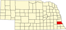
Location of Otoe County in Nebraska
This is a list of the National Register of Historic Places listings in Otoe County, Nebraska.
This is intended to be a complete list of the properties and districts on the National Register of Historic Places in Otoe County, Nebraska, United States. The locations of National Register properties and districts for which the latitude and longitude coordinates are included below, may be seen in a map.[1]
There are 26 properties and districts listed on the National Register in the county, including 1 National Historic Landmark. Another two properties that were once listed have been removed.
- This National Park Service list is complete through NPS recent listings posted September 17, 2021.[2]
Current listings[]


Former listing[]
| [3] | Name on the Register | Image | Date listed | Date removed | Location | City or town | Description |
|---|---|---|---|---|---|---|---|
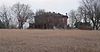
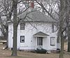
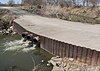
| 1 | June 29, 1992 (#92000723) | December 19, 2012 | County road over the , 3 miles (4.8 km) northwest of Syracuse 40°40′00″N 96°14′09″W / 40.666667°N 96.235833°W | Syracuse | |||
| 2 |  |
November 15, 2000 (#00001379) | March 25, 2019 | 5797 H Road[14] 40°40′57″N 95°55′00″W / 40.682436°N 95.916631°W | Nebraska City | Apparently removed or demolished[15] |
See also[]
| Wikimedia Commons has media related to National Register of Historic Places in Otoe County, Nebraska. |
- List of National Historic Landmarks in Nebraska
- National Register of Historic Places listings in Nebraska
References[]
- ^ The latitude and longitude information provided in this table was derived originally from the National Register Information System, which has been found to be fairly accurate for about 99% of listings. Some locations in this table may have been corrected to current GPS standards.
- ^ National Park Service, United States Department of the Interior, "National Register of Historic Places: Weekly List Actions", retrieved September 17, 2021.
- ^ Jump up to: a b Numbers represent an alphabetical ordering by significant words. Various colorings, defined here, differentiate National Historic Landmarks and historic districts from other NRHP buildings, structures, sites or objects.
- ^ The eight-digit number below each date is the number assigned to each location in the National Register Information System database, which can be viewed by clicking the number.
- ^ See photo.
- ^ See photos: this one for Q, this one for the 6903 address (lower right corner).
- ^ "Harmony School". Otoe County Genealogical Society. Retrieved 2012-03-05.
- ^ "Kregel Windmill Museum". Retrieved 2012-04-18.
- ^ "Contact Us". Archived 2013-06-21 at the Wayback Machine Morton-James Public Library. Retrieved 2013-06-15.
- ^ Miller, Greg. "National Register of Historic Places Registration Form: Nebraska City Burlington Depot". Nebraska State Historical Society. Retrieved 2012-03-05.
- ^ "Farmers Bank & Trust Co." Archived 2012-04-26 at the Wayback Machine Retrieved 2012-04-19.
- ^ Jump up to: a b "Wildwood Historic Center". Retrieved 2012-03-05.
- ^ See June 2013 photos at Commons:Category:Wyoming Creek bridge, CR 60, Otoe County, Nebraska for current bridge. According to uglybridges.com, the current bridge was built in 2003.
- ^ "Mc Cartney Public School". Nebraska Department of Education. Retrieved 2012-03-05.
- ^ See June 2013 photos at Commons:Category:McCartney School District 17 (Otoe County, Nebraska). NRHP nominating form lists a single contributing building, a red brick schoolhouse. A basketball hoop and pump visible in photos are mentioned in the form, but no contributing structures or objects are listed. A July 14, 2009 article in the Nebraska City News-Press states that the Nebraska City School Board voted to sell the school.
| show Municipalities and communities of Otoe County, Nebraska, United States |
|---|
Categories:
- Lists of National Register of Historic Places in Nebraska by county
- Otoe County, Nebraska
- Buildings and structures in Otoe County, Nebraska
- National Register of Historic Places in Otoe County, Nebraska